Delaware Route 273
| ||||
|---|---|---|---|---|
 | ||||
| Route information | ||||
| Maintained by DelDOT | ||||
| Length: | 12.67 mi[1] (20.39 km) | |||
| Existed: | 1936[2] – present | |||
| Major junctions | ||||
| West end: |
| |||
|
| ||||
| East end: |
| |||
| Location | ||||
| Counties: | New Castle | |||
| Highway system | ||||
| ||||

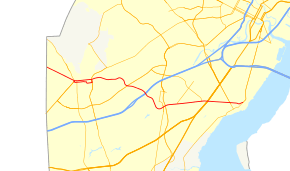
Delaware Route 273 (DE 273) is a state highway in New Castle County, Delaware. The route runs from Maryland Route 273 (MD 273) at the Maryland border near Newark east to DE 9 and DE 141 in New Castle. The route runs through suburban areas between Newark and New Castle as a four-lane divided highway, passing through Ogletown and Christiana. DE 273 intersects DE 896 in downtown Newark, DE 2/DE 72 on the eastern edge of Newark, DE 4 in Ogletown, Interstate 95 (I-95), DE 7, and DE 1 in Christiana, DE 37 in Pleasantville, and DE 58 and U.S. Route 13 (US 13)/US 40 in Hares Corner.
What is now DE 273 was originally built as a state highway in the 1920s and 1930s, with the portion east of Hares Corner becoming a part of US 40, which had crossed the Delaware River on a ferry between New Castle and Pennsville, New Jersey. DE 273 was designated by 1936 to connect the Maryland border near Newark to Hares Corner. In the 1950s, the route was extended to New Castle when US 40 was realigned to the Delaware Memorial Bridge. DE 273 was moved onto new alignments around Christiana in the 1980s and through Ogletown in the 1990s.
Route description
DE 273 begins at the Maryland border west of Newark, where it continues west into that state as MD 273. From the state line, the route heads southeast on two-lane undivided Nottingham Road, passing through wooded suburban neighborhoods as it enters Newark, passing to the south of the Newark Country Club. DE 273 becomes West Main Street as it approaches the downtown area, intersecting the southbound direction of DE 896, at which point DE 273 forms a concurrency with southbound DE 896. The road crosses CSX's Philadelphia Subdivision and comes to an intersection with New London Road, which runs northwest as northbound DE 896, and South Main Street, which heads southwest as DE 896.[3][4]
At this point, DE 273 splits into the one-way pair of West Delaware Avenue eastbound and West Main Street westbound, with eastbound DE 273 briefly following one-way South Main Street southwest to get from West Main Street to West Delaware Avenue. The one-way pair, which carries two lanes in each direction, becomes concurrent with DE 896 in both directions until the South College Avenue intersection. DE 273 runs through the University of Delaware campus and continues through the downtown as East Delaware Avenue eastbound and East Main Street westbound. Farther east, East Delaware Avenue shifts farther to the south of East Main Street, with the one-way streets passing between a residential neighborhood and East Delaware Avenue passing to the north of Newark High School. Past here, the route comes to an intersection with DE 2/DE 72. At this point, eastbound DE 273 turns north to join DE 72 on four-lane divided Library Avenue to rejoin westbound DE 273.[3][4]
Past DE 2/DE 72, DE 273 leaves Newark and heads east on Ogletown Road, a five-lane road with a center left-turn lane that passes through commercial areas, soon becoming a four-lane divided highway. The road continues east and comes to a bridge over Amtrak's Northeast Corridor. The route turns southeast and reaches an interchange with DE 4 in Ogletown. Past this interchange, DE 273 becomes Christiana Road and heads east through suburban residential neighborhoods with some businesses. The road bends southeast again as it comes to an interchange with I-95 (Delaware Turnpike). Following this, the route heads into more commercial areas and becomes Christiana Road, bypassing the community of Christiana to the southwest. DE 273 runs south through wooded areas and crosses Old Baltimore Pike before curving east and coming to an intersection with DE 7. A short distance later, the road reaches an interchange with the DE 1 freeway.[3][4]

Following this interchange, DE 273 heads through woods before entering areas of suburban homes and businesses, coming to an intersection with the southern terminus of DE 37 in Pleasantville. The route continues east and intersects the eastern terminus of DE 58 near the Wilmington Airport. A short distance later, the road comes to an intersection with US 13/US 40 in Hares Corner.[3][4]
Past this intersection, DE 273 becomes concurrent with DE 9 Truck and turns into two-lane undivided Frenchtown Road, heading east between business parks to the south and farm fields to the north. DE 273 comes to an intersection with DE 9 and DE 141 to the west of New Castle, where the route, along with DE 9 Truck, officially ends. Despite this, DE 273 signage continues east along DE 9 toward New Castle on Delaware Street. Along this stretch, the road crosses the New Castle Industrial Track Trail. Before reaching the New Castle Historic District after a crossing of Norfolk Southern's New Castle Secondary, DE 9/DE 273 makes a left turn onto Ferry Cut Off Street. DE 273's signed eastern terminus is at Sixth Street near the Delaware River, where DE 9 turns northeast on Sixth Street to head toward Wilmington.[3][4]
DE 273 has an annual average daily traffic count ranging from a high of 49,566 vehicles at the I-95 interchange to a low of 8,760 vehicles at the western edge of Newark.[1] The portion of DE 273 east of DE 896 is part of the National Highway System.[5]
History
What is now DE 273 originally existed as a county road by 1920.[6] Four years later, the portion of road through Newark was upgraded to a state highway while the road was paved between Hares Corner and New Castle.[7] A year later, the section between Ogletown and Christiana was planned as a state highway while the section east of Basin Road was upgraded to a state highway.[8] In 1930, the road between the Maryland border and Newark was built as a state highway, providing a shorter route to the Conowingo Dam in Maryland.[9] The following year, US 40 was designated to run on the portion of road between Hares Corner and New Castle, where it connected to a ferry across the Delaware River to Pennsville, New Jersey. Also by this time, all of present-day DE 273 was upgraded to a state highway except the portion of US 40 between Hares Corner and Basin Road.[10] In 1934, recommendations were made to upgrade US 40 to a state highway between Hares Corner and New Castle.[11] The portion of US 40 between Hares Corner and New Castle was taken over by the state on July 1, 1935.[12][2] Construction on upgrading this section began in 1936.[13] This project was completed later that year.[2] The same year, a bridge was constructed over a Pennsylvania Railroad line (now the New Castle Industrial Track Trail) in New Castle.[13]
DE 273 was designated to run from the Maryland border west of Newark east to US 13 and US 40 in Hares Corner by 1936, roughly following its current alignment. In Newark, the route ran concurrent with DE 2.[2] By 1952, US 40 was realigned to use the Delaware Memorial Bridge to cross the Delaware River, and DE 273 was extended east along the former alignment of US 40 to end at present-day DE 9 in New Castle.[14] In 1956, DE 2 and DE 273 were routed onto the one-way pair of Delaware Avenue eastbound and Main Street westbound in downtown Newark following an eastward extension of Delaware Avenue to the intersection between DE 2 and DE 273 east of the city.[15]
By 1984, DE 9 was realigned to follow DE 273 east of the DE 141 intersection.[16] DE 273 was realigned to bypass Christiana a year later.[17] DE 2 was routed to bypass Newark and DE 2 Bus. became concurrent with DE 273 through Newark by 1990.[18] By 1997, DE 273 was moved to its current alignment in the Ogletown area, eliminating a short concurrency with DE 4 and involving the construction of an interchange with that route.[19] The concurrent DE 2 Bus. designation was eliminated in 2013 as part of simplifying the route numbers in Newark.[20]
Major intersections
The entire route is in New Castle County.
| Location | mi[1] | km | Destinations | Notes | |
|---|---|---|---|---|---|
| Newark | 0.00 | 0.00 | Maryland state line, western terminus | ||
| 1.73 | 2.78 | Southbound direction of DE 896, west end of DE 896 southbound overlap | |||
| 1.85 | 2.98 | East end of DE 896 southbound overlap, west end of DE 896 northbound overlap | |||
| 2.04 | 3.28 | Northbound direction of DE 896, east end of DE 896 northbound overlap | |||
| 3.03 | 4.88 | West end of eastbound overlap with DE 72 | |||
| 3.23 | 5.20 | East end of eastbound overlap with DE 72 | |||
| Ogletown | Interchange | ||||
| Christiana | 6.99 | 11.25 | I-95 exit 3 | ||
| 8.58 | 13.81 | ||||
| DE 1 exit 162 | |||||
| Pleasantville | 9.46 | 15.22 | |||
| Hares Corner | 10.96 | 17.64 | |||
| 11.32 | 18.22 | West end of DE 9 Truck overlap | |||
| New Castle | 12.67 | 20.39 | Eastern terminus | ||
1.000 mi = 1.609 km; 1.000 km = 0.621 mi
| |||||
See also
 U.S. Roads portal
 Delaware portal
References
- 1 2 3 Staff (2011). "Traffic Count and Mileage Report: Interstate, Delaware, and US Routes" (PDF). Delaware Department of Transportation. Retrieved May 17, 2012.
- 1 2 3 4 Delaware State Highway Department; The National Survey Co. (1936). Official Road Map of the State of Delaware (PDF) (Map) (1936–37 ed.). Dover: Delaware State Highway Department. Retrieved November 24, 2015.
- 1 2 3 4 5 Delaware Department of Transportation (2008). Delaware Official Transportation Map (PDF) (Map). Dover: Delaware Department of Transportation. Retrieved November 24, 2015.
- 1 2 3 4 5 Google (February 7, 2011). "overview of Delaware Route 273" (Map). Google Maps. Google. Retrieved February 7, 2011.
- ↑ National Highway System: Delaware (PDF) (Map). Federal Highway Administration. 2010. Retrieved February 10, 2012.
- ↑ Delaware State Highway Department (1920). Official Road Map (PDF) (Map). Dover: Delaware State Highway Department. Retrieved November 24, 2015.
- ↑ Delaware State Highway Department (1924). Official Road Map (PDF) (Map). Dover: Delaware State Highway Department. Retrieved November 24, 2015.
- ↑ Delaware State Highway Department (1925). Official Road Map (PDF) (Map). Dover: Delaware State Highway Department. Retrieved November 24, 2015.
- ↑ "Annual Report of the State Highway Department" (PDF) (1930 ed.). Dover, Delaware: Delaware State Highway Department. December 31, 1930: 19. Retrieved November 14, 2014.
- ↑ Delaware State Highway Department (1931). Official Road Map of the State of Delaware (PDF) (Map). Dover: Delaware State Highway Department. Retrieved November 24, 2015.
- ↑ "Annual Report of the State Highway Department" (PDF) (1934 ed.). Dover, Delaware: Delaware State Highway Department. January 1, 1935: 37, 68. Retrieved November 10, 2014.
- ↑ "Annual Report of the State Highway Department of the State of Delaware" (PDF) (1935 ed.). Dover, DE: Delaware State Highway Department. January 7, 1936: 7. Retrieved November 19, 2014.
- 1 2 "Annual Report of the State Highway Department" (PDF) (1936 ed.). Dover, Delaware: Delaware State Highway Department. January 20, 1937: 19-21. Retrieved November 10, 2014.
- ↑ Delaware State Highway Department (1952). Official Highway Map of Delaware (PDF) (Map) (1952–53 ed.). Dover: Delaware State Highway Department. Retrieved November 24, 2015.
- ↑ "Report of the State Highway Department" (PDF) (1956 ed.). Dover, Delaware: Delaware State Highway Department. July 1, 1956: 11. Retrieved November 12, 2014.
- ↑ Delaware Department of Transportation (1984). Official State Highway Map (PDF) (Map). Dover: Delaware Department of Transportation. Retrieved November 24, 2015.
- ↑ Delaware Department of Transportation (1985). Official State Highway Map (PDF) (Map). Dover: Delaware Department of Transportation. Retrieved November 24, 2015.
- ↑ Delaware Department of Transportation (1990). Official State Map (PDF) (Map). Dover: Delaware Department of Transportation. Retrieved November 24, 2015.
- ↑ Delaware Department of Transportation (1997). Official Transportation Map (PDF) (Map). Dover: Delaware Department of Transportation. Retrieved November 24, 2015.
- ↑ Shannon, Josh (July 1, 2013). "A route to less clutter: DelDOT to consolidate Newark route numbers". Newark Post. Retrieved August 15, 2013.
External links
 Media related to Delaware Route 273 at Wikimedia Commons