Delaware and Raritan Canal
|
Delaware and Raritan Canal | |
|
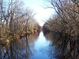
A section of the canal as seen from a footbridge (2013) | |
| Location | New Jersey, United States |
|---|---|
| Built | 1834 |
| NRHP Reference # | 73001105 |
| NJRHP # | 1600[1] |
| Significant dates | |
| Added to NRHP | May 11, 1973 |
| Designated NJRHP | November 30, 1972 |

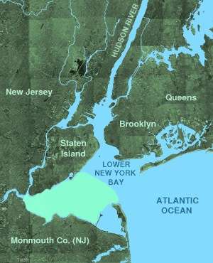
The Delaware and Raritan Canal (D&R Canal) is a canal in central New Jersey, United States, built in the 1830s that served to connect the Delaware River to the Raritan River. It was intended as an efficient and reliable means of transportation of freight between Philadelphia, Pennsylvania and New York City, especially coal from the anthracite coal fields in eastern Pennsylvania. Before the advent of the railroads, the canal allowed shippers to cut many miles off the route from the Pennsylvania coal fields, down the Delaware, around Cape May, and up along the (occasionally treacherous) Atlantic Ocean coast to New York City.
History
The idea of a canal between the Raritan and Delaware Rivers had a long history, going back to William Penn, the founder of Pennsylvania, who suggested it in the 1690s. Such a canal would shorten the journey from Philadelphia to New York by 100 miles, and relieve the need for boats to venture into the Atlantic Ocean.[2]
In 1816, the New Jersey legislature created a commission of three people, including John Rutherfurd, a former United States Senator and a major landowner in New Jersey, which was authorized to survey and map a proposed route for a canal. Rutherfurd engaged John Randel Jr. to do the survey; Rutherfurd knew Randel from his work on the New York City Commissioners' Plan of 1811, for which Rutherfurd was one of the commissioners, and Randel was the chief surveyor. The route was to be "a level line as far as was practicable from Longbridge farm to the Delaware, and to the Raritan, in the shortest direction direction that the ground would admit, which line should be run with the greatest accuracy, and be esteemed the base line of the work." Randel spent two months surveying this route and, with the aid of a millwright, estimating water flow. They came to the conclusion that the canal would require less than an eighteenth of the water passing through the local streams, which would still leave enough water flow for local mills.[3] Despite Randel's report, and the clear advantage of having such a canal, the opposition to the project managed to keep anything from happening until 1830.[2]
On February 4, 1830, the New Jersey legislature passed legislation that created the charter for the D&R Canal. The charter for the Camden and Amboy Rail Road and Transportation Company was passed the same day. The D&R charter allocated $1.5 million of stock for construction which was required to be completed within eight years. The canal was to be considered a public highway although the corporation would be allowed to collect tolls and transit duties for passengers and cargo transported along the canal.[4]
The canal system was dug mostly by hand tools, mostly by Irish immigrants. Work began in 1830 and was completed in 1834, at an estimated cost of $2,830,000. When the canal first opened, teams of mules were used to tow canal boats through it (the steam engine was not yet applied to such uses).
The canal's greatest usage occurred during the 1860s and 1870s, when it was used primarily to transport coal from Pennsylvania to New York City, which had entered the Industrial Revolution. On May 18, 1872, the D&R Canal Company was merged with several parallel railroads into the United New Jersey Railroad and Canal Company, and leased by the Pennsylvania Railroad. Over time, the importance of the D&R Canal waned as railroads were used to perform, more rapidly, the same function as canals, but it remained in operation until 1932. Years later, the section between Trenton and Bordentown was filled for various road and rail projects, leaving the feeder waters to solely supply the main canal from Trenton northwards to New Brunswick. Two other sections of the canal were piped underground: one in Trenton when the Trenton Freeway (U.S. Route 1) was constructed in 1952, and the other in New Brunswick when the Elmer Boyd Parkway Extension (Route 18) was constructed in 1984.
Route
_from_the_Southard_Street_overpass_in_Trenton%2C_New_Jersey.JPG)
The main section of the canal runs from Bordentown on the Delaware to New Brunswick on the Raritan. A feeder canal section (which feeds water into the main canal) stretches 22 miles (35 km) northward from Trenton, upstream along the east bank of the Delaware to Bull's Island near Frenchtown. The feeder canal collects water from higher elevations to the north, and feeds it to the highest section of the main canal, which flows generally north and east to the end, and had flowed south into the Crosswicks Creek at Bordentown. The total length of the entire canal system was approximately 66 miles (106 km). The main section was 44 miles (71 km) long, 75 feet (23 m) wide and 8 feet (2.4 m) deep; the feeder was 22 miles (35 km) long, 60 feet (18 m) wide and 6 feet (2 m) deep.
Altered and abandoned sections
A section of the main D&R Canal in Trenton has been covered over (the water still flows below) by the Trenton Freeway and is inaccessible to public use. The portion of the canal that provided access to the Delaware River in Bordentown is also abandoned. In Trenton it has been covered by NJ Route 129, which opened in 1996. Another section south of Trenton is located in Hamilton Township, Mercer County, New Jersey between the southern boundary of Trenton and the Crosswicks Creek.[5]
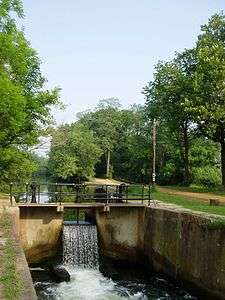
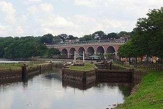
Locks and spillways
Locks were used to overcome elevation differences along the D&R canal. Many of the locks are still present along the canal route; however, the lock gates have been replaced on the upstream side with small dams and water outfalls. The downstream gates have been removed, so the water in the locks is level with the water on the downstream side. Some of the locks have been buried or removed due to construction projects in the vicinity of the canal.
A number of spillways, which drained excess water from the canal into nearby waterways during periods of heavy flow, are located along the canal route. Spillways are evident as a dip in the tow path along the canal. Some have paving stones spaced closely enough for mules to walk, but are impassable for bicycles. With the flow stopped, species typical of stagnant water live in them.
Associated rivers
- Delaware River - Feeds the Delaware and Raritan Canal via a feeder canal that approaches from the north along the east bank of the Delaware River, starting at Bulls Island, to the southern terminus of the D&R Canal near Trenton.
- Millstone River - Parallels the Delaware and Raritan Canal from Princeton north to Manville. A flood control study is currently being conducted for the Millstone River basin by two government organizations, which may affect the Delaware and Raritan Canal in the future.
- Raritan River - Parallels the Delaware and Raritan Canal from Manville north and east to New Brunswick. The northern terminus of the Delaware and Raritan Canal is in New Brunswick.
Landmark
The Delaware and Raritan Canal was added to the National Register of Historic Places on May 11, 1973.[6] The many historic canal houses where the bridge tenders have lived (such as the Blackwells Mills Canal House and the Port Mercer Canal House) were listed as contributing properties.
State Park
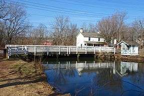
In 1974, most of the canal system was declared a New Jersey state park. It remains one today, and is used for canoeing, kayaking, and fishing. A graded natural-surface trail along the side of the canal, which was the tow path that mules used to tow barges on the canal before steam powered barges, is now used for hiking, jogging, bicycling, and horseback riding. Some 36 miles (58 km) of the main canal, and all 22 miles (35 km) of the feeder canal, still exist. The feeder canal along the Delaware, being a former railroad rather than a towpath, is especially suited to bicycling. The park is operated and maintained by the New Jersey Division of Parks and Forestry.
The canal is accessible from many points along its route, with small parking areas providing access at most road crossings. One of the most scenic and popular sections of the D&R Canal state park is the segment along Lake Carnegie in Princeton, New Jersey, which features the canal on one side of the path and the lake on the other side. Another attractive section borders the Colonial Park Arboretum and Gardens in East Millstone.
When the canal was used for transportation, New Jersey's landscape was mostly rural, and its primary business was agriculture. "Now," in the words of Howard Green, research director of the New Jersey Historical Commission, "It is one of the most beloved parks in the state, a sinewy, snake-like greenway through one of the most heavily populated parts of the world. It has gone from being the machine in the garden, to being garden in the machine."
Gallery
 Rural area
 The feeder canal, Lambertville, New Jersey
 Another view from Lambertville
See also
References
Notes
- ↑ "New Jersey and National Registers of Historic Places — Mercer County" (PDF). New Jersey Department of Environmental Protection — Historic Preservation Office. April 5, 2013. p. 8. Retrieved June 4, 2013.
- 1 2 Holloway, Marguerite (2013), The Measure of Manhattan: The Tumultuous Career and Surprising Legacy of John Randel Jr., Cartographer, Surveyor, Inventor, New York: W. W. Norton, pp. 183–84, ISBN 978-0-393-07125-2
- ↑ Holloway, Marguerite (2013), The Measure of Manhattan: The Tumultuous Career and Surprising Legacy of John Randel Jr., Cartographer, Surveyor, Inventor, New York: W. W. Norton, pp. 178–79, ISBN 978-0-393-07125-2 quoting the 1817 Report of the Commissioners to the New Jersey State Legislature
- ↑ Robertson, Aaron; Hulme, James S.; Wurts, A. (1850). Report of Commissioners Appointed to Investigate Charges Made Against the Directors of the Delaware and Raritan Canal and Camden and Amboy Railroad and Transportation Companies. Trenton, NJ: Philips and Boswell.
- ↑ "The Delaware & Raritan Canal: The Past, The Present and the Promise". The Municipal Land User Center at The College of New Jersey. June 1, 2005. Archived from the original on February 5, 2012. Retrieved February 11, 2016.
- ↑ Historic Sites Survey Team (May 11, 1973). "NRHP Nomination: Delaware and Raritan Canal" (PDF). National Park Service. "Accompanying 17 photos, from 1971." (PDF).
Bibliography
- Delaware & Raritan Canal State Park, brochure, New Jersey Division of Parks and Forestry, State Park Service, July 2002
External links
| Wikimedia Commons has media related to Delaware and Raritan Canal. |
- Delaware and Raritan Canal Commission
- The Delaware & Raritan Canal Transmission Complex - The D&R Canal is still used by the State of New Jersey to transport water resources to population centers.
- Historic American Buildings Survey (HABS) No. NJ-713, "Delaware & Raritan Canal Lock"
- Historic American Engineering Record (HAER) No. NJ-60-A, "Delaware & Raritan Canal, Lock"
- HAER No. NJ-60-B, "Delaware & Raritan Canal, Locktender's House"
- HAER No. NJ-61, "Delaware & Raritan Canal, Outlet Locks"
- HAER No. NJ-62, "Delaware & Raritan Canal, Lock 6A"
- HAER No. NJ-67, "Delaware & Raritan Canal, Six Mile Run Culvert"
- HAER No. NJ-68, "Delaware & Raritan Canal, Ten Mile Run Culvert"
- HAER No. NJ-129, "Delaware & Raritan Canal, Lock 4"
- 40°09′06″N 74°42′58″W / 40.1517°N 74.7161°W - Southern terminus of canal
- 40°29′19″N 74°26′02″W / 40.4886°N 74.4340°W - Northern terminus of canal
- 40°24′55″N 75°02′48″W / 40.4152°N 75.0467°W - Northern terminus of feeder canal
| Preceded by |
The Delaware and Raritan Canal Company chartered February 4, 1830 merged May 18, 1872 |
Succeeded by The United New Jersey Railroad and Canal Company |
Areas |  | |
| Historic Districts | ||
| Former municipalities | ||
Education | ||
| Public schools | ||
| Independent schools | ||
| Colleges and universities | ||
| Other education | ||
Other | ||
| Places of Worship | ||
| Parks and Recreation | ||
| Shopping, and Dining | ||
| Performing Arts | ||
| Media | ||
| Other landmarks | ||
| Princeton addressed landmarks outside the municipality | ||
See also: Princeton University and National Register of Historic Places listings in Mercer County, New Jersey | ||