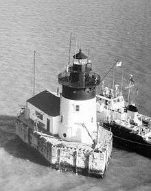
Detroit River Light
 Undated USCG photo | |
 | |
| Location |
Lake Erie south of Detroit River, Monroe County, near Berlin Charter Township |
|---|---|
| Coordinates | 42°0′2.7″N 83°8′26.45″W / 42.000750°N 83.1406806°WCoordinates: 42°0′2.7″N 83°8′26.45″W / 42.000750°N 83.1406806°W |
| Year first constructed |
1875 (lightship) 1885 (current tower) |
| Automated | 1979 |
| Foundation |
Wood/cement crib Granite pier |
| Construction | Cast iron with brick lining |
| Tower shape | frustum of a cone with attached building.[1] |
| Markings / pattern | White with black top |
| Height | 49 feet (15 m) |
| Original lens | 4th order Fresnel lens |
| Range | 10 nautical miles (19 km; 12 mi) |
| Characteristic | Fl(2) W 6s |
| Fog signal | Horn: 1 every 30s |
| Racon | "X" (X-ray) |
| ARLHS number | USA-227[2][3] |
| USCG number | |
|
Detroit River Light Station | |
| Nearest city | Rockwood, Michigan[7] |
| Area | 0.1 acres (0.040 ha) |
| Built | 1884 |
| Architect | Davis C.E.L.B. |
| MPS | U.S. Coast Guard Lighthouses and Light Stations on the Great Lakes TR |
| NRHP Reference # | 83000886[8] |
| Added to NRHP | August 04, 1983 |
The Detroit River Light, also known as Bar Point Shoal Light, was first established as a lightship in 1875. The current sparkplug lighthouse was built in 1885.[6] It sits in Lake Erie, south of the mouth of the Detroit River, 1.75 nautical miles (3.24 km; 2.01 mi) from land and about 20 nautical miles (23 mi; 37 km) from the Ambassador Bridge in the Detroit River. It is about 0.4 nautical miles (0.74 km; 0.46 mi) from the border with Canada,[9] and just under 24 nautical miles (44 km; 28 mi) from Put-in-Bay, Ohio.[10] Its original 4th order Fresnel lens is on loan to the Michigan Maritime Museum.[4]
Construction and infrastructure
The Detroit River Light replaced a Canadian lightship that had been posted in this channel location since 1875, guiding upbound vessels making a turn in the Detroit River.
The United States Lighthouse Board completed the Detroit River Light in 1885 at a cost of $78,000. The Light was first lit on August 20, 1885.[11]
The crib was transported to the site from Amherstburg, Ontario. It was built pre-fabricated 45 by 18 feet (13.7 by 5.5 m), sunk in 22 feet (6.7 m) of water, filled with concrete and surrounded by a granite pier. The light station pier is shaped like a vessel. Its pointed end is directed toward the mouth of the river to break river-powered ice floes. Above the crib and pier, the 49 feet (15 m) high cast iron boiler plate tower is 22 feet (6.7 m) in diameter at its base and 18 feet (5.5 m) at the top.[11] There is an attached storage building and radio beacon.[12]
Challenges in construction
Construction was eventful and problematic. When the crib settled, it was uneven, about 16 inches (410 mm) off level. As winter was approaching and work set to stop, 550 short tons of stone were loaded onto the pier, "mostly on the high side." Upon the crews return the following spring, gravity and ice floes had made the granite pier level.[13][14]
Operational history
Detroit River Light was constructed to be a manned lighthouse. Coast Guardsmen assigned to this close-but-eerily-isolated station used to refer to it as "The Rock."[14] The light is now automated.
With Prohibition the light served as a rendezvous point for rum runners.[13] The nearby city of Windsor was a noted point for the distillation of Canadian whiskey, much of which was exported to the U.S.
The light today
In December 1997 the 635-foot (194 m) freighter M/V Buffalo[15] struck the station dead on (a "direct hit"[16]) as it sailed down bound for Lake Erie. The station suffered minimal damage to rock and stone foundation. The freighter had its steel bow pushed "in like a tin can" with a 25-foot (7.6 m) gash.[11][17]
The lens has been changed several times, and this has altered the characteristic signal generated by the light to passing boats and ships. The present lens has six panels of 60 degrees, with three bull's-eye panels each separated from the other by a 60 degree blind panel.
The station contains a fog signal, similar to Harbor Beach Light (also built in 1885). The station is an active aid to navigation, is closed to visitors, and visible only from a boat.[11] A good launch point is the south end of the island of Grosse Ile, Michigan.[18]
It was added to the National Register of Historic Places as Detroit River Light Station on August 4, 1983, reference number 83000886.[8]
The light has been memorialized in sculptures.[13]
Keepers
- Charles Northup (1885–1886 and 1893–1898)
- Richard Oddrey (1887–1890)
- Joseph Crawford (1898–1902)
- Enoch Scribner (1902–1912)
- Horace Watts (1912–1916)
- Walter Marshall (1916–1919)
- Harry K Condway (1919–1921)
- John Sweet (1926–1933)
- William Small (1933–1938)
- Eli Martin (1938–1939)[6]
References
- ↑ Pepper, Terry. "Database of Lighthouse Types and Tower Shapes". Seeing the Light. terrypepper.com.
- ↑ Amateur Radio Lighthouse Society, Bar Point Shoal/Detroit River Light ARLHS USA-227.
- ↑ Amateur Radio Lighthouse Society, World List of Lights. Archived April 21, 2009, at the Wayback Machine.
- 1 2 Rowlett, Russ (2009-11-13). "Lighthouses of the United States: Michigan's Eastern Lower Peninsula". The Lighthouse Directory. University of North Carolina at Chapel Hill.
- ↑ Light List, Volume VII, Great Lakes (PDF). Light List. United States Coast Guard. 2009. p. 74.
- 1 2 3 "Historic Light Station Information and Photography: Michigan". United States Coast Guard Historian's Office.
- ↑ Certain documents list the Detroit River Light as being part of or being closest to the city of Rockwood, Michigan. As the closest city, Rockwood is in Wayne County, but the lighthouse is within the northernmost water boundaries of Berlin Charter Township in Monroe County. However, the Detroit River Light is owned and operated by the United States Coast Guard and is therefore not under the jurisdiction of any municipality.
- 1 2 "National Register Information System". National Register of Historic Places. National Park Service. 2009-03-13.
- ↑ NOAA Chart 14848 Detroit River Michigan Extension
- ↑ Photo of Detroit River Light.
- 1 2 3 4 Wobser, David, Bar Point Shoal Lighthouse at boatnerd.com
- ↑ "Detroit River Lighthouse". Michigan Lighthouse Conservancy.
- 1 2 3 Harbour Lights, Detroit River Lighthouse
- 1 2 Greenwood, Tom, Detroit River Light (September, 1998) Lighthouse Digest.
- ↑ Photo of M/V Buffalo at boatnerd.com.
- ↑ Roach, Jerry, Lighthouse Central, Detroit River Lighthouse Photographs, History and Directions, The Ultimate Guide to East Michigan Lighthouses (Publisher: Bugs Publishing LLC - July 2006). ISBN 0-9747977-1-5; ISBN 978-0-9747977-1-7.
- ↑ Photo of damage to S.S. Buffalo at boatnerd.com.
- ↑ Anderson, Kraig, Lighthouse Friends, Detroit River Lighthouse.
Further reading
- Greenwood, Tom, Detroit River Light (September, 1998) Lighthouse Digest.
- Nolan, Jenny, How the Detroit River shaped lives and history (February 11, 1997), Detroit News.
External links
- Aerial photo of Detroit River Lighthouse at marinas.com.
- Satellite view of Detroit River (Bar Point Shoal) Lighthouse at Google maps.
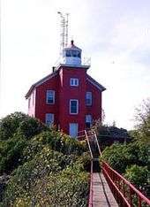
- Colchester Reef Light (Lake Erie, West)
| Northern Upper Peninsula |
|  |
|---|---|---|
| Southern Upper Peninsula | ||
| St. Mary's River |
| |
| Portage River/Ship Canal |
| |
| Straits of Mackinac | ||
| Western Lower Peninsula |
| |
| Eastern Lower Peninsula |
| |
| Historical (lost) lights |
| |
| Related | ||
