St. Martin Island Light
 St. Martin Island Light USCG Archive | |
 | |
| Location | St. Martin Island Lake Michigan |
|---|---|
| Coordinates | 45°30′10″N 86°45′27″W / 45.50278°N 86.75750°WCoordinates: 45°30′10″N 86°45′27″W / 45.50278°N 86.75750°W |
| Year first constructed | 1905 |
| Year first lit | 1905 |
| Foundation | Granite[1] |
| Construction | Steel exoskeleton[1] |
| Markings / pattern | white with black lantern[1] |
| Height | 75 ft (23 m)[2] |
| Focal height | 81 feet (25 m)[3] |
| Original lens | occulting 4th Order Fresnel illuminated by a 24,000 candlepower incandescent oil vapor lamp. Rotating red and white flash panels.[4] |
| Current lens | 7.5-inch (190 mm) Tideland Signal acrylic lens[5] |
| Range | 18 nautical miles (33 km; 21 mi)[6] |
| Characteristic | Al W R 10s: W fl 5s ec.; R fl 5s ec. Light visible from 135° to 355°, dark sector covering island.[6] |
| ARLHS number | USA-802[7][8] |
| USCG number |
7-21450 |
|
St. Martin Island Light Station | |
| Nearest city | Fairport, Michigan |
| Area | 2 acres (0.81 ha) |
| MPS | U.S. Coast Guard Lighthouses and Light Stations on the Great Lakes TR |
| NRHP Reference # | 84001387[9] |
| Added to NRHP | July 19, 1984 |
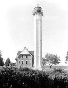
St. Martin Island Light is an exoskeleton lighthouse that marks one of four passages between Lake Michigan and the bay of Green Bay.[10] Constructed in 1905, this light tower is the only example in the US of a pure exoskeletal tower on the Great Lakes. Similar designs exist in Canada.[11] Painted white, the hexagonal tower is made of iron plates which are supported by six exterior steel posts that have latticed buttresses.[4][12]
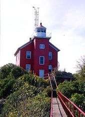
The cream city brick lightkeeper's house was modeled after that used for the Plum Island Range Lights.[4]
It was listed on the National Register of Historic Places on July 19, 1984, Reference #84001387 as St. Martin Light Station (U.S. Coast Guard/ Great Lakes TR). It is not on the state list/inventory.[13] A steam fog signal was also installed.[14] which was thereafter replaced by a diaphone.[4]
The lighthouse keeper's dwelling has been abandoned and "is in poor condition."[12]
The light station is closed to the public. It is managed by in partnership with the Little Traverse Bay Band of the Odawa Indian Nation.[11][15]
References
- 1 2 3 "Historic Light Station Information and Photography: Michigan". United States Coast Guard Historian's Office.
- ↑ Pepper, Terry. "Database of Tower Heights". Seeing the Light. terrypepper.com.
- ↑ Pepper, Terry. "Database of Focal Heights". Seeing the Light. terrypepper.com.
- 1 2 3 4 Pepper, Terry, Seeing the Light, St. Martin Island Lighthouse.
- ↑ Michigan Lighthouse Conservancy, St. Martin Island Light.
- 1 2 Light List, Volume VII, Great Lakes (PDF). Light List. United States Coast Guard.
- ↑ "Amateur Radio Lighthouse Society, St. Martin Island (Lake Michigan) Light ARLHS USA-802".
- ↑ "Amateur Radio Lighthouse Society, World List of Lights.".
- ↑ National Park Service (2009-03-13). "National Register Information System". National Register of Historic Places. National Park Service.
- ↑ Wobser, David, St. Martin Island Light, boatnerd.com.
- 1 2 Rowlett, Russ. "Lighthouses of the United States: Michigan's Eastern Upper Peninsula". The Lighthouse Directory. University of North Carolina at Chapel Hill.
- 1 2 Lighthouse Depot, St. Martin Island Light.
- ↑ National Park Service Maritime History Project, Michigan Lighthouses, Inventory of Historic Light Stations, St. Martin Island Light
- ↑ Saint Martin Island Light Station, Michigan Historic Sites Online,
- ↑ Little Traverse Bay Band of the Odawa Indian Nation.
External links
- Detroit News, Interactive map on Michigan lighthouses, which fails to list St. Martin Island Light.
- Interactive map of Lights in Northern Lake Michigan, mapped by Google.
- Map of Michigan Lighthouse in PDF Format.
- Map of lighthouses in western Lake Michigan.


