Devalls, Louisiana
| DeValls | |
| Unincorporated community | |
| Country | United States |
|---|---|
| State | Louisiana |
| Parish | West Baton |
| Elevation | 30 ft (9.1 m) [1] |
| Coordinates | 30°31′34.7952″N 91°17′43.1406″W / 30.526332000°N 91.295316833°WCoordinates: 30°31′34.7952″N 91°17′43.1406″W / 30.526332000°N 91.295316833°W |
| Population | 900 (2007) |
| Timezone | CST (UTC-6) |
| - summer (DST) | CDT (UTC-5) |
| ZIP code | 70767 |
| Area code | 225 |
 Location of DeValls in Louisiana
| |
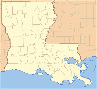
 Location of Louisiana in the United States
| |
DeValls (also known as Devalls, DeVall, or Devall) is an unincorporated community in the 5th Ward of West Baton Rouge Parish, Louisiana, United States.[2] DeValls is located approximately 20 miles northwest of Baton Rouge, Louisiana, and is a part of the Baton Rouge Metropolitan Area. The community is situated along the Mississippi River in northeastern West Baton Rouge. The community is served by Louisiana Highway 415, known locally as the River Road. Nearby Devall Middle School is similarly named.
References
- ↑ "DeValls, Louisiana". Geographic Names Information System. United States Geological Survey. June 4, 1980. Retrieved 2008-06-29.
- ↑ http://louisiana.hometownlocator.com/la/west-baton-rouge/devalls.cfm
Municipalities and communities of West Baton Rouge Parish, Louisiana, United States | ||
|---|---|---|
| City | 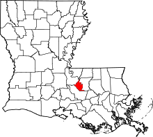 | |
| Towns | ||
| CDP | ||
| Unincorporated community | ||
This article is issued from Wikipedia - version of the 11/4/2015. The text is available under the Creative Commons Attribution/Share Alike but additional terms may apply for the media files.