Devils Lake (North Dakota)
| Devils Lake | |
|---|---|
 View from space (March 2009) | |
| Location | Ramsey / Benson counties, North Dakota, USA |
| Coordinates | 48°2′5″N 98°56′39″W / 48.03472°N 98.94417°WCoordinates: 48°2′5″N 98°56′39″W / 48.03472°N 98.94417°W |
| Lake type |
Endorheic basin Potentially an open lake owing to climate change |
| Catchment area | 3,810 sq mi (9,900 km2) |
| Basin countries | United States |
| Surface elevation | 1,454.20 ft (443.24 m) |
| Settlements | Devils Lake, Minnewaukan |
Devils Lake is a lake in the U.S. state of North Dakota. It is the largest natural body of water and the second-largest body of water in North Dakota after the artificially created Lake Sakakawea. In 2011, it reached an unofficial historical high elevation of 1454.30 feet (443m). The lake can reach 1458.0 before naturally flowing into the Sheyenne River via the Tolna Coulee.
The city of Devils Lake, North Dakota, takes its name from the lake. The Spirit Lake Reservation is located on the lake's southern shores. The name "Devils Lake" is an approximate translation of its Lakota name, Ble Waka Sica ("blay wah-kahn shee-chah"; literally: "Lake of the Spirits"). Its Arikara name is "čiwahaahwaarúxtiʾ [čiWAhaahwaarúxti’]".[1]
Geography
Devils Lake is located in Ramsey County and Benson County in northeastern North Dakota. The Spirit Lake Tribe occupies most of the southern shore and has been adversely affected by flooding since the 1990s.
Hydrology
Devils Lake is the endorheic, or closed, lake of a drainage basin of some 3,800 mi² (9,800 km²), the Devils Lake Basin. The lake collects around 86 percent of the basin's water runoff.[2] Above a level of some 1,447 ft (441 m)(NAVD88) AMSL the lake spills into neighboring Stump Lake. At 1,458 ft (444 m) (NAVD88) the combined lake flows naturally into the Sheyenne River, though the lake has not reached this level in approximately 1000[3] years. The Sheyenne River is a tributary to the Red River, which flows into Canada, with eventual exit into the Hudson Bay.[2] Current dike protection is set at 1454 ft (443 m)(NAVD88).
Under normal conditions, Devils Lake is shallow, saline, and hypereutrophic (very high in nutrients). During periods of excessive precipitation, however, the lake can be quite deep (up to 60 feet (18 m) in places), eutrophic (rich in minerals, nutrients, and organisms), with decreased salinity due to dilution.[2]
Salinity
Because Devils Lake is endorheic, the lake tends to be much higher in salinity than are lakes with outlets to river systems. This is similar to the Great Salt Lake in Utah.[4] Lower water levels increase salinity threatening fish and wildlife.[4] Salinity levels in the lake have been one prominent aspect of the debate over diversion of lake water into the Sheyenne River, with questions of the potential environmental impact of the diverted water on downstream rivers, lakes, and communities.[5]
Flooding
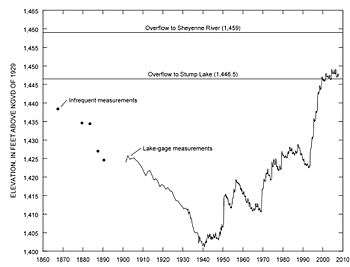

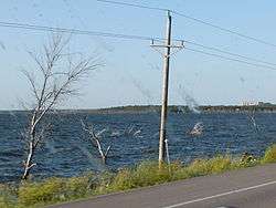
Devils Lake is well known for its wide variations in lake levels,[6] with large swings between low and high water levels. This owes in large part to its nature as a closed-basin lake, lacking a natural outlet. The release of water is dependent upon evaporation and seepage.[4]
The low, flat terrain around Devils Lake consists of various coulees, channels, and basins, which may be separated during times of low water, or connected during high water.[4] Thus the boundaries of the lake can vary greatly from year to year, depending on the amount of precipitation.
The draining of wetlands to develop agricultural land in the area has aggravated flooding at Devils Lake. Drainage of the basin's wetlands and conversion of the basin's native prairie to cropland has resulted in water moving more rapidly into the lake, increasing water levels.[7] In addition, the diversion of natural water flows is also considered to have contributed to the flooding.[7]
An increase in precipitation between 1993 and 1999 caused the lake to double in size, forcing the displacement of more than 300 homes and flooding 70,000 acres (280 km2) of farmland.[8] The Spirit Lake Tribe, whose reservation is along part of the lake, suffered considerable damage to homes and lands. Attempts to mitigate the flooding have reportedly cost North Dakota and the U.S. government more than $450 million. Efforts to control flooding include dike construction and moving railroad lines, roads, and power lines.[9]
In response to the flooding, the U.S. Congress directed the Army Corps of Engineers to research construction of an outlet in 1997 to control the lake level through methods other than evaporation or natural overflow.[5] The Corps' design included mechanisms for filtration and monitoring of the water, and was estimated to cost $186.5 million.[10]
The state of North Dakota objected to the cost and certain water quality provisions of the plan, and declined to participate in construction of the Corps' outlet.[5] In 2003, the state constructed its own outlet to divert water from Devils Lake into the Sheyenne River, at a cost of $28 million.[8] The outlet was completed in 2005, but was not operated in 2006 due to water quality and biota issues.[5] The outlet operated at the maximum permitted rate for the first time in July 2009.[11]
The National Weather Service is the official federal government agency responsible for observing and predicting water levels at Devils Lake.[12]
Recreation
Devils Lake has long been known for fishing and other watersports. It has been named the perch capital of the world. There are a number of boat ramps and other facilities around the lake to facilitate recreational activities on the lake. Recreation in the form of open water and ice fishing is estimated to have generated more than $20 million annually.
Sullys Hill National Game Preserve is located on the lake's southern shore. Grahams Island State Park is located on an island in the lake. Other parks on the lake include Black Tiger State Recreation Area and Shelvers Grove State Recreation Area,[13] which is now closed due to the lake's flooding.
Issues and controversies
Outlet controversy
During the most recent wet cycle which began in 1993, the lake rose over 26.5 ft (8.1 m), inundating 140 mi² (363 km²) of primarily agricultural land. This required the expenditure of more than $400 million in flood protection measures.[8] Some stakeholders argued for construction of an emergency outlet into the Sheyenne River, which is a tributary of the Red River of the North.
The Army Corps of Engineers proposed to draw water from a different point of the lake, provide filtration, and discharge a maximum of 300 ft³/s (8 m³/s) of water from Devil's Lake, in order to lessen dependence on overflow or evaporation to reduce water levels.[5] The Corps of Engineers estimated its project costs to amount to $186.5 million, with the United States Congress designating $100 million to the project; North Dakota would have paid the remaining amount.[8] Because the project potentially affected the Red River of the North, which runs into Canadian waters, the project was considered to be covered by the Boundary Waters Treaty, and international issues were raised.[5][8]
Led by Republican Governor John Hoeven, North Dakota objected to the water quality provisions and the amount of funding required.[5] Instead it constructed its own outlet, with approval of the North Dakota Department of Health, the U.S. State Department, and Council on Environmental Quality. This outlet, which cost $28 million, has a lower maximum discharge than the federal proposal (limited to a maximum of 100 ft³/s (2.8 m³/s) by the Section 402 NDPDES Permit); its gravel filter removes only larger organisms. But it has provided some relief to the flood problem.[14] Construction began in 2003 and was completed as of summer 2005.
The state outlet project was opposed by the governments of Minnesota and Manitoba, Canada. They argue the outlet would create the potential for the transfer of unknown foreign aquatic species and high levels of sulfates into the Red River basin, an important agricultural area, and Lake Winnipeg, the world's 10th-largest freshwater lake.[15]
In March 2004, Manitoba, along with Minnesota and several environmental groups, sued the North Dakota Department of Health in state court over the Devils Lake Outlet 402 NDPDES Permit. The court ruled the outlet could proceed in August 2004 and May 2005.
The Boundary Waters Treaty of 1909 established an intermediary, the International Joint Commission (IJC), through which the United States and Canada can solve cross-boundary water disputes, but the commission has no power to act without invocation by both nations.[16] Canada attempted to invoke the IJC for purposes of conflict resolution, but the United States did not, effectively preventing the IJC from taking part in the controversy.[17]
The Government of Canada argues that the diversion by the state, without consultation or approval from Canada, is a violation of the Boundary Waters Treaty of 1909 and Canada's national sovereignty. The U.S. government contends the diversion will not be harmful, nor will it violate the treaty under current conditions.
In November 2005, a joint United States and Canadian study concluded that none of the 13 species Canada classifies as invasive were present in Devils Lake. The study did find three species of fish parasites that are not currently known to exist in Lake Winnipeg (to which the Red River flows). However, all three are ubiquitous to the waters of North America and have a wide variety of hosts. A difficulty inherent in determining what species are in Devils Lake versus Lake Winnipeg results from spatial relationships and scale.
Lake Winnipeg covers approximately 9,400 mi² (24,300 km²), dozens of times larger than Devils Lake. In addition, the Devils Lake Basin is significantly smaller than the watersheds feeding Lake Winnipeg, including the Saskatchewan River basin at approximately 56,000 mi² (145,000 km²). Drawing conclusions about the biological community already in Lake Winnipeg is difficult, due to the relative lack of biological sampling there compared to that of the smaller Devils Lake.
Carp
Due to the rising waters of the Devils Lake and its basin, streams can flow into the Red River Valley or the Devils Lake Basin. The Red River Valley basin contains a "rough fish", the common carp, which the North Dakota Game and Fish Department fears will enter Devils Lake basin waters in the near future, allowing the carp to populate Devils Lake. The carp's fast reproductive growth and the lack of carp predators in the lake will likely help it to dramatically increase in population. This could have drastic consequences for existing populations of game fish, such as the walleye and northern pike, which could greatly harm the sport fishing industry.
Some preventive measures have been proposed, including inserting chemicals in the creeks along the boundary of the Devils Lake Basin and the Red River Valley to kill fish. Biologists did tests in 2005 which conclude that there are currently no carp in the Devils Lake Basin, but some have been found within two miles (3 km). The carp appear to have been stalled by the abundant cattail plants, which makes travel impossible for the fish.
Railroad problems
From 2009 to 2013, the BNSF Railway temporarily ended freight service between Devils Lake and Church's Ferry, a total of 19 miles (31 km), due to the lake's rising waters. Instead, it shifted freight traffic to its Northern Transcon route. Amtrak's Empire Builder (which travels a total of 2200 miles) was operating on this route, serving Grand Forks, Devils Lake, and Rugby, North Dakota. BNSF offered Amtrak the right to operate over the Northern Transcon subdivision, and suggested Amtrak make a station stop at New Rockford, but Amtrak said that they would continue using the line by the lake. In 2010 analysts estimated that Amtrak would soon either have to rebuild the bridge that crosses the lake at Church's Ferry, or reroute its passenger trains.[18]
On June 15, 2011, BNSF and Amtrak announced reaching an agreement to rebuild the rail line. Each would cover one-third of the cost, and the state of North Dakota received a federal TIGER grant to cover its portion. The growth of freight traffic associated with oil from the Bakken formation in this period resulted in BNSF upgrading its assessment of the importance of the Devils Lake line.[19] [20] After the track was rebuilt and raised, through service resumed from Devils Lake to Church's Ferry.
References
- ↑ "AISRI Dictionary Database Search – Arikara. Prototype version". Retrieved 2012-07-08.
- 1 2 3 Devils Lake Basin Joint Water Resource Board. North Dakota State Water Commission. 2006. 2006 Devils Lake Basin Water Management Plan.
- ↑ "Prehistoric Water Levels".
- 1 2 3 4 Rosenberg, Sheryl A. 2000. "A Canadian Perspective on the Devils Lake Outlet: Towards an Environmental Assessment Model for the Management of Transboundary Disputes." North Dakota Law Review 76: 817–59.
- 1 2 3 4 5 6 7 Hollis, Duncan B. 2007. "Disaggregating Devils Lake: Can Non-State Actors, Hegemony, or Principal-Agent Theory Explain the Boundary Waters Treaty?" In Responsibility of Individuals, States and Organizations.
- ↑ Runaway Devils Lake » American Scientist
- 1 2 Bryn, Eric M. 1996. "Through a Biodiversity Looking-Glass: An Analysis of the Devils Lake Water Management Plan." Great Plains Natural Resources Journal 1: 65–96.
- 1 2 3 4 5 Kempf, Bart. 2007. "Draining Devils Lake: The International Lawmaking Problems Created by the Devils Lake Outlet," Georgetown International Environmental Law Review.
- ↑ "Devils Lake Basin in North Dakota." United States Geological Survey Water Science Center. http://nd.water.usgs.gov/devilslake/index.html.
- ↑ Brouwer, Greg. 2003. "Corps Approves Devils Lake Diversion," Civil Engineering: 18–19.
- ↑ "The article requested cannot be found! Please refresh your browser or go back. (MO,,2009,7,AR).". Devils Lake Journal (Devils Lake, ND).
- ↑ National Weather Service hydrograph for Devils Lake: http://www.crh.noaa.gov/ahps2/hydrograph.php?wfo=fgf&gage=dcbn8&view=1,1,1,1,1,1,1,1
- ↑ "Shelvers Grove State Recreation Area - Google Maps". google.com.
- ↑ Landers, Jay. 2005, Oct. "North Dakota Begins Operating Devils Lake Diversion," Civil Engineering: 18.
- ↑ "Judge upholds changes to Devils Lake outlet's operating permit". TwinCities.com.
- ↑ Boundary Waters Treaty of 1909
- ↑ Flanders, Joseph M. 2006. "Transboundary Water Disputes on an International and State Platform: A Controversial Resolution to North Dakota's Devils Lake Dilemma," North Dakota Law Review 82, 3.
- ↑ Fred W. Frailey, "Minus its backbone, Amtrak makes a tempting target," Trains, August 2010, p. 18
- ↑ Ross B. Capon, "AMTRAK’S LONG-DISTANCE TRAINS: BRIEF HISTORY, BENEFITS, INFRASTRUCTURE CHALLENGES", for Midwest Interstate Passenger Rail Commission, 9 June 2014; accessed 1 November 2016
- ↑ , Grand Forks Herald
External links
- Devils Lake from the United States Geological Survey
- Devils Lake hydrograph from the National Weather Service
- Devils Lake from the North Dakota State Water Commission
- Devils Lake Outlet 402 NDPDES Permit from the North Dakota Department of Health
- Legal Article/Analysis Devils Lake, Social Sciences Research Network. North Dakota Law Review