Dharmatala
{{Infobox settlement <!-:Infobox Settlement for additional fields that may be available-->
|name =Dharmatala
|official_name =
|other_name =
|native_name =
|nickname =
|settlement_type =Neighbourhood in Kolkata (Calcutta)
|total_type =
|motto =
|image_skyline = |imagesize = |image_caption = |image_flag = |flag_size = |image_seal = |seal_size = |image_shield = |shield_size = |image_blank_emblem = |blank_emblem_type = |blank_emblem_size = |image_map =Kolkata street-Dharmatala.svg |mapsize =300px |map_caption = |image_map1 = |mapsize1 = |map_caption1 = |image_dot_map = |dot_mapsize = |dot_map_caption = |dot_x |dot_y = |pushpin_map = |pushpin_label_position = |pushpin_map_caption = |pushpin_mapsize =
|coordinates_display =inline,title
|coordinates_region =IN-WB
|subdivision_type =Country
|subdivision_name =![]() India
|subdivision_type1 =State
|subdivision_name1 =West Bengal
|subdivision_type2 =City
|subdivision_name2 =Kolkata
|subdivision_type3 =Ward
|subdivision_name3 =#46, 47, 50, 51
|subdivision_type4 =Metro Station
|subdivision_name4 =Esplanade
India
|subdivision_type1 =State
|subdivision_name1 =West Bengal
|subdivision_type2 =City
|subdivision_name2 =Kolkata
|subdivision_type3 =Ward
|subdivision_name3 =#46, 47, 50, 51
|subdivision_type4 =Metro Station
|subdivision_name4 =Esplanade
|seat_type = |seat = |parts_type = |parts_style = |parts = |p1 = |p2 =
|government_footnotes = |government_type = |leader_title = |leader_name = |leader_title1 = |leader_name1 = |established_title = |established_date =
|area_magnitude = |unit_pref =Imperial |area_footnotes = |area_total_km2 = |area_land_km2 = |area_water_km2 = |area_total_sq_mi = |area_land_sq_mi = |area_water_sq_mi = |area_water_percent =
|elevation_footnotes = |elevation_m = |elevation_ft =36 |elevation_max_m = |elevation_max_ft = |elevation_min_m = |elevation_min_ft =
|population_as_of = |population_footnotes = |population_note = |population_total = |population_density_km2 = |population_density_sq_mi =
|timezone =IST |utc_offset =+5:30 |timezone_DST = |utc_offset_DST = |coor_type = |latd=23.8 |latm|lats|latNS=N |longd=88.25 |longm|longs|longEW=E
|postal_code_type =PIN |postal_code = |area_code =+91 33 |website = |footnotes = }}
Dharmatala (archaic spelling Dhurrumtollah) (Bengali: ধর্ম্মতলা) is a neighbourhood in central Kolkata, earlier known as Calcutta, in the Indian state of West Bengal. Dharmatala Street has been renamed Lenin Sarani but the neighbourhood continues to be referred to as Dharmatala. It is a busy commercial area that had come up with the growth of Calcutta during the British Raj and is thus one of the repositories of history in the city.
Etymology
Dharmatala means Holy Street. It is commonly held to derive its name from a large mosque which stood at the site of Cook and Company’s livery stables. Some discern the name as a reference to dharma, one of the units of the Buddhist Trinity. There was a Buddhist temple at Janbazar, nearby. Tipu Sultan Mosque at the corner of Chowringhee Road and Dharmatala, was built in 1842, by Prince Gholam Mohammad, a son of Tipu Sultan.[1] Bioy Ghosh feels that the name Dharmatala is because of the preeminence of Dharmathakur in olden days. Haris and Doms, who are worshippers of Dharmathakur, predominated the area even in the memorable past.[2]
Geography
Dharmatala extends from Chowringhee Road (renamed Jawaharlal Nehru Road) to Lower Circular Road (renamed Jagadish Chandra Bose Street). It is bounded to the north by Bowbazar and the south by Janbazar.[1]
The neighbourhood is spread over ward nos. 46, 47, 50 and 51 of Kolkata Municipal Corporation.[3] 65546409+496+4
History
In the 18th century, Dharmatala is described as ‘a well raised causeway, raised by deepening the ditch on both sides.’ It was shaded with trees on both sides.[1]
Just north of Dharmatala a creek formerly ran from Chandpal Ghat to Beliaghata (or Baliaghata, as it was then known). The creek passed through what was later Wellington Square (renamed Subodh Chandra Mallick Square) and Creek Row. The earlier name of Creek Row was Dhinga Bhanga, as a ship broke there during the cyclone of 1737. The creek was navigable for large boats. Wellington Square was a tank made on the bed of this creek. Both Wellington Square and Creek Row were developed by the Lottery Committee. Calcutta Gazette of 9 August 1821 refers to Wellington Square as ‘the new square in Dhurrumtollah.’[1]
While the English quarter was then restricted to around the old fort (present B. B. D. Bagh), the area south of Dharmatala was a jungle. The native quarters to the north consisted of a number of straggling villages.[4]
After their victory in the Battle of Plassey, the English decided to build new Fort William, in 1758. For this purpose, the native population shifted from Gobindapur mostly to Sutanuti. The European inhabitants of Kalikata gradually forsook the narrow limits of the old palisades and moved to around the Maidan.[5] Civilians were not allowed to live within the new fort. Gradually the areas to the south of the Great Tank and to the east along Chowringhee Road were emerging as preferred haunts for the Englishmen. While Sutanuti developed as the Black Town, the Esplanade and Chowringhee emerged as the White Town. However, the areas around Writers' building, Baitakkhana (Bowbazar), Dharmatala and Janbazar went down in estimation and were gradually taken over by ‘the rest’, which included half-castes, Portuguese, Armenians and so on, 'to become grey areas between Black and White Towns of old Calcutta'.[6]
The district lying between Dharmatala and Bowbazar and bounded on the west by Bentinck Street was in the 19th and 20th century inhabited by a variety of people that included Portuguese, other Europeans of poorer classes, and Indians. The area was full of ‘tortuous and narrow lanes, badly drained and reeking with foul odours, thickly populated and miserably housed.’ In this district on the northern side of Dharmatala is a bazaar called Chandney Chowk. ‘It is a labyrinth of ill-kept passages, lined with shops, in which may be found a wonderful collection of sundries, from a door nail to a silk dress.’ [7]
Dharmatala Bazar was established in 1794 at the corner of Dharmatala and Chowringhee. Rudyard Kipling in the last chapter of his Kolkata sketches published under the title of The City of Dreadful Nights, has given a lively description of the market and its frequenters.[8] It was formerly called Shakespeare’s Bazar.[1]
In the earliest list of police stations in Kolkata made in 1785, both Dharmatala and Dingabhanga were included. However, when the police stations were reorganised in 1888-89, the number of police stations were reduced and no mention is there of either.[9]
Transport
A three-horse omnibus plied briefly between Dharmatala and Barrackpore in November 1830 but the truly successful horse-drawn public transport was the tramcar. These were introduced in Dharmatala in March 1882. In 1899, the Calcutta Tramways Company started electrifying the entire system.[10]
References
- 1 2 3 4 5 Cotton, H.E.A., Calcutta Old and New, 1909/1980, pp. 248-50, General Printers and Publishers Pvt. Ltd.
- ↑ Ghosh, Binoy, Paschim Banger Sanskriti, (in Bengali), part II, 1978 edition, p. 252, Prakash Bhaban
- ↑ Map nos. 29, 30, and 32, Detail Maps of 141 Wards of Kolkata, D.R.Publication and Sales Concern, 66 College Street, Kolkata – 700073
- ↑ Nair, P. Thankappan, The Growth and Development of Old Calcutta, in Calcutta, the Living City, Vol. I, edited by Sukanta Chaudhuri, p. 11, Oxford University Press, ISBN 978-0-19-563696-3.
- ↑ Cotton, H.E.A., p. 72
- ↑ Lahiri Choudhury, Dhriti Kanta, Trends in Calcutta Architecture, in Calcutta, the Living City, Vol I, pp.159-160
- ↑ Cotton, H.E.A., p. 219
- ↑ Cotton, H.E.A., p. 771
- ↑ Nair, P. Thankappan, The Growth and Development of Old Calcutta, p. 15.
- ↑ Nair, P.Thankappan, Civic and Public Services in Old Calcutta, in Calcutta, the Living City, Vol I, pp. 234-6
Gallery
| Wikimedia Commons has media related to Dharmatala. |
 A part of Chandni Chawk Street
 A closer view of Tipu Sultan Mosque
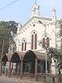 Thoburn Memorial Methodist Church established in 1873
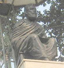 Statue of Utkalmani Pandit Gopabandhu Das
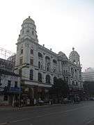 The Metropolitan Building(Esplanade) in Dharmatala, Kolkata
External links
![]() Kolkata/Esplanade travel guide from Wikivoyage
Kolkata/Esplanade travel guide from Wikivoyage