Division of Berowra
| Berowra Australian House of Representatives Division | |
|---|---|
|
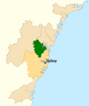
Division of Berowra in New South Wales, as of the 2016 federal election. | |
| Created | 1969 |
| MP | Julian Leeser |
| Party | Liberal |
| Namesake | Berowra, New South Wales |
| Electors | 105,292 (2016) |
| Area | 786 km2 (303.5 sq mi) |
| Demographic | Outer Metropolitan |
The Division of Berowra is an Australian electoral division in the state of New South Wales. The division was created in 1969 and is named for the suburb of Berowra.
Its boundaries have changed little since it was created, and it includes the suburbs of Annangrove, Arcadia, Berowra, Berowra Creek, Berowra Heights, Berowra Waters, Berrilee, Brooklyn, Canoelands, Cheltenham, Cherrybrook, Cowan, Dangar Island, Dural, Fiddletown, Fishermans Point, Forest Glen, Galston, Glenorie, Hawkesbury River, Hornsby Heights, Kenthurst, Laughtondale, Maroota, Middle Dural, Milsons Passage, Mount Kuring-Gai, Pennant Hills, Round Corner, Sackville North, Singletons Mill, South Maroota, Thornleigh, and Westleigh; as well as parts of Asquith, Beecroft, Carlingford, Castle Hill, Cattai, Glenhaven, Hornsby, Leets Vale, Lower Hawkesbury, Lower Portland, Maraylya, Mount Colah, Normanhurst, West Pennant Hills, and Wisemans Ferry.
The seat has always been a safe seat for the Liberal Party.
Members
| Member | Party | Term | |
|---|---|---|---|
| Tom Hughes | Liberal | 1969–1972 | |
| Harry Edwards | Liberal | 1972–1993 | |
| Philip Ruddock | Liberal | 1993–2016 | |
| Julian Leeser | Liberal | 2016–present | |
Election results
| Party | Candidate | Votes | % | ± | |
|---|---|---|---|---|---|
| Liberal | Julian Leeser | 53,678 | 57.09 | −4.39 | |
| Labor | Josh Andrews | 18,693 | 19.88 | +0.85 | |
| Greens | Emma Heyde | 10,815 | 11.50 | +1.47 | |
| Christian Democrats | Leighton Thew | 5,213 | 5.54 | +3.05 | |
| Independent | Mick Gallagher | 2,859 | 3.04 | −0.62 | |
| Science | Brendan Clarke | 1,933 | 2.06 | +2.06 | |
| Independent | Roger Woodward | 826 | 0.88 | +0.88 | |
| Total formal votes | 94,017 | 95.84 | +1.44 | ||
| Informal votes | 4,082 | 4.16 | −1.44 | ||
| Turnout | 98,099 | 93.17 | −3.87 | ||
| Two-party-preferred result | |||||
| Liberal | Julian Leeser | 62,470 | 66.45 | −2.60 | |
| Labor | Josh Andrews | 31,547 | 33.55 | +2.60 | |
| Liberal hold | Swing | −2.60 | |||
References
- ↑ Berowra, NSW, Virtual Tally Room 2016, Australian Electoral Commission.
External links
Coordinates: 33°34′05″S 151°02′49″E / 33.568°S 151.047°E
