Dolegna del Collio
| Dolegna del Collio | |
|---|---|
| Comune | |
| Comune di Dolegna del Collio | |
 Dolegna del Collio Location of Dolegna del Collio in Italy | |
| Coordinates: 46°2′N 13°29′E / 46.033°N 13.483°ECoordinates: 46°2′N 13°29′E / 46.033°N 13.483°E | |
| Country | Italy |
| Region | Friuli-Venezia Giulia |
| Province / Metropolitan city | Province of Gorizia (GO) |
| Frazioni | Mernicco, Restoccina, Ruttars, Scriò, Trussio, Breg, Lonzano, Venco, Barbana nel Collio |
| Government | |
| • Mayor | Diego Bernardis |
| Area | |
| • Total | 12.5 km2 (4.8 sq mi) |
| Elevation | 90 m (300 ft) |
| Population (Dec. 2004) | |
| • Total | 419 |
| • Density | 34/km2 (87/sq mi) |
| Time zone | CET (UTC+1) |
| • Summer (DST) | CEST (UTC+2) |
| Postal code | 34070 |
| Dialing code | 0481 |
Dolegna del Collio (Slovene: Dolenje) is a comune (municipality) in the Province of Gorizia in the Italian region Friuli-Venezia Giulia, located about 50 kilometres (31 mi) northwest of Trieste and about 15 kilometres (9 mi) northwest of Gorizia, on the border with Slovenia. As of 31 December 2004, it had a population of 419 and an area of 12.5 square kilometres (4.8 sq mi).[1]
The municipality of Dolegna del Collio contains the frazioni (subdivisions, mainly villages and hamlets) Mernicco, Restoccina, Ruttars, Scriò, Trussio, Breg, Lonzano, Venco, and Barbana nel Collio.
Dolegna del Collio borders the following municipalities: Brda (Slovenia), Cormons, Corno di Rosazzo, Prepotto.
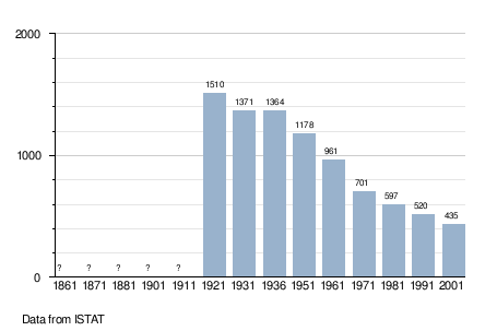
Demographic evolution
References
This article is issued from Wikipedia - version of the 1/31/2015. The text is available under the Creative Commons Attribution/Share Alike but additional terms may apply for the media files.