Friuli-Venezia Giulia
| Friuli-Venezia Giulia | |||
|---|---|---|---|
| Autonomous region of Italy | |||
| |||
 | |||
| Country | Italy | ||
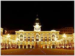
| Capital | Trieste | ||
| Government | |||
| • President | Debora Serracchiani (PD) | ||
| Area | |||
| • Total | 7,856 km2 (3,033 sq mi) | ||
| Population (31 December 2013) | |||
| • Total | 1,229,363 | ||
| • Density | 160/km2 (410/sq mi) | ||
| Time zone | CET (UTC+1) | ||
| • Summer (DST) | CEST (UTC+2) | ||
| GDP/ Nominal | €36.2[1] billion (2008) | ||
| GDP per capita | €29,200[2] (2008) | ||
| NUTS Region | ITD | ||
| Website | www.regione.fvg.it | ||

Friuli-Venezia Giulia ([friˈuːli veˈnɛttsja ˈdʒuːlja];[lower-alpha 1] Friulian: Friûl–Vignesie Julie, Slovene: Furlanija–Julijska krajina, German: Friaul–Julisch Venetien) is one of the 20 regions of Italy, and one of five autonomous regions with special statute. The capital is Trieste. (Note that Venezia, i.e. Venice, is not in this region, despite the name.) It has an area of 7,858 km² and about 1.2 million inhabitants. A natural opening to the sea for many Central European countries, the region is traversed by the major transport routes between the east and west of southern Europe. It encompasses the historical-geographical region of Friuli and a small portion of the historical region of Venezia Giulia (known in English also as Julian March), each with its own distinct history, traditions and identity. The name of the region was spelled Friuli–Venezia Giulia until 2001, when, in connection with a modification of article nr. 116 of the Italian constitution, the official spelling Friuli Venezia Giulia was adopted.[3][4]
Geography
Friuli Venezia Giulia is Italy's most North-Eastern region. It covers an area of 7,858 km2 and is the fifth smallest region of the country. It borders Austria to the north and Slovenia to the east. To the south it faces the Adriatic Sea and to the west its internal border is with the Veneto region.
The region spans a wide variety of climates and landscapes from the mild Oceanic in the south to Alpine continental in the north. The total area is subdivided into a 42.5% mountainous-alpine terrain in the north, 19.3% is hilly, mostly to the south-east, while the remaining 38.2% comprises the central and coastal plains.
Morphologically the region can be subdivided into four main areas. The mountainous area in the north: this part of the region includes Carnia and the ending section of the Alps (Carnic Alps and Julian Alps), of which the highest peaks exceed 2,700 m above sea level (Jôf di Montasio 2,754 m). Its landscapes are characterised by vast pine forests and pastures, mountain lakes (e.g. Sauris,Fusine and Barcis) and numerous streams and small rivers descending from the mountains. The area is also known for its tourist destinations, especially during the winter season (Monte Zoncolan, Tarvisio, Sella Nevea, Forni di Sopra and Piancavallo). The hilly area, situated to the south of the mountains and along the central section of the border with Slovenia. The main product of agriculture in this area is wine, whose quality, especially the white, is known worldwide. The easternmost part of the hilly area is also known as Slavia Friulana, as it is mostly inhabited by ethnic Slovenes. The central plains are characterised by poor, arid and permeable soil. The soil has been made fertile with an extensive irrigation system and through the adoption of modern intensive farming techniques. In this part of the region most of the agricultural activities are concentrated. The coastal area can be further subdivided in two, western-eastern, subsections separated by the river Isonzo's estuary. To the west, the coast is shallow and sandy, with numerous tourist resorts and the lagoons of Grado and Marano Lagunare. To the east, the coastline rises into cliffs, where the Kras plateau meets the Adriatic, all the way to Trieste and Muggia on the border with Slovenia. The Carso has geological features and phenomena such as hollows, cave networks and underground rivers, which extend inland in the provinces of Trieste and Gorizia, with an altitude ranging between 300m and 600m.

The rivers of the region flow from the North and from Slovenia into the Adriatic. The two main rivers are the Tagliamento, which flows west-east in its upper part in the Carnic Alps and then bends into a north-south flow that separates the Julian Alps from Alpine foothills and the Isonzo (Soča slo.) which flows from Slovenia into Italy. The Timavo is an underground river that flows for 38 km from Slovenia and resurfaces near its mouth north-west of Duino.
The region Friuli Venezia Giulia has a temperate climate. However, due to the terrain's diversity, it varies considerably from one area to another. Walled by the Alps on its northern flank, the region is exposed to air masses from the East and the West. The region receives also the southerly Sirocco from the Adriatic sea, which brings in heavy rainfall. Along the coast the climate is mild and pleasant. Trieste records the smallest temperature differences between winter and summer and between day and night. The climate is Alpine-continental in the mountainous areas, where, in some locations, the coldest winter temperatures in Italy can often be found. The Kras plateau has its own weather and climate, influenced, mostly during autumn and winter, by masses of cold air coming from the North-East. These generate a very special feature of the local climate: the north-easterly wind Bora, which blows over the Gulf of Trieste with gusts occasionally exceeding speeds of 150 km/h.
History
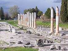
In Roman times, modern Friuli Venezia Giulia was located within Regio X Venetia et Histria of Roman Italy. The traces of its Roman origin are visible over all the territory. In fact, the city of Aquileia, founded in 181 BC, served as capital of the region and rose to prominence in the Augustan period.
Starting from the Lombard settlements (6th century), the historical paths of Friuli and Venezia Giulia begin to diverge. In 568, Cividale del Friuli (the Roman Forum Iulii (from which the name Friuli comes)) became the capital of the first Lombard dukedom in Italy. In 774, the Franks, favoured the growth of the church of Aquileia and established Cividale as a March. In 1077, Patriarchate of Aquileia was given temporal power by the Holy Roman Emperors and this power was extended temporarily even to the east. But already in the 12th century Gorizia had actually become independent and Trieste, along with other coastal towns, organized itself as a free city-state.
In the 6th century, the Alpine Slavs, ancestors of present-day Slovenes, settled the eastern areas of the region. They settled in the easternmost mountainous areas of Friuli, known as the Friulian Slavia, as well as the Kras Plateau and the area north and south from Gorizia. In the 12th and 13th century, they also moved closer to Trieste.

Friuli became Venetian territory in 1420, while Trieste and Gorizia remained under the Austrian Empire. Pordenone was a "corpus separatum", under Austrian influence until 1515, when it also fell under the Venetian rule. With the peace treaty of Campoformido in 1797, Venetian domination came to an end and Friuli was ceded to Austria. After the period of domination by Napoleon, which affected also Trieste and Gorizia, it again became part of the Austrian Empire and was included in the Lombard-Veneto Kingdom, while Gorizia was merged with the Illyrian Kingdom and Trieste, together with Istria, became part of the Austrian Coastal Region. The enlightened policy of the Austrian-Hungarian Empire in the 18th and 19th centuries encouraged an extraordinary economic flourishing, making Trieste the empire’s port. The outcome of the war of independence brought Friuli alone into the Kingdom of Italy.
After the First World War, in which this region was a main theatre of operations and suffered serious damage and loss of lives, the fates of these border lands were again united, although Venezia Giulia, in particular, was the subject of contradictions regarding the borders.
The Second World War led to the Anglo-American Administration in Trieste until the border was fixed with the Memorandum of London in 1954 . When Trieste was taken back by Italy, the Autonomous Region of Friuli Venezia Giulia could finally be established .[5] The Italian Constitution assigns it the status of Region with a Special Statute, together with four other Italian regions. However, Friuli – Venezia Giulia obtained administrative autonomy and the special statute only in 1963. The reasons for this "constitutional delay" are interwoven with the international problems of the second postwar period and with those deriving from the region’s "diversity" – the different historical, ethnic, and linguistic components that go to make up this area. In 1975 the Treaty of Osimo was signed in Osimo, definitively dividing the former Free Territory of Trieste between Italy and Yugoslavia.
Economy
The economy of Friuli–Venezia Giulia is one of the most developed in the country. Its core is based on small- and middle-size enterprises (the so-called 'North-East model'), on specialized farming and on high-quality tourism with a significant inclination towards exports.[6]
Agriculture and farming maintain an essential role in the economy of the region and employed in 2001 around 95,000 persons. Its high quality products are exported not only within the country and Europe (fruit and vegetable, cheese) but have become known worldwide for their quality (cured ham and wines, especially white ones). Noteworthy is also the production of soy (third producer in Italy with more than 37,000 hectares cultivated in 2000) and timber production in Carnia.[6]
As mentioned above, the economy of the region is based on a widespread mosaic of small and medium-size enterprises; of particular importance are the four industrial districts where a multitude of such highly specialised enterprises are concentrated. These districts are centred around the towns of Manzano, San Daniele del Friuli (cured ham), Maniago (knives) and Brugnera (furniture). A number of large enterprises are also present in the region in both the industry and services sector. Some of these companies are world-leaders in their relevant sectors; such are Fincantieri (headquarters in Trieste with shipyards in Monfalcone) for the construction of the world's largest cruise ships, Zanussi-Electrolux (Pordenone) in the production of electrical appliances, Danieli, Eurotech, Illy, Rizzani de Eccher, Solari Udine, TBS Group, Banca Generali, Genertellife, Italia Marittima, Telit, Wärtsilä, Allianz Italia and Assicurazioni Generali in Trieste, a leading insurance companies in the world.[6]
Local craftsmanship can boast products of the highest quality, such as fabrics, carved furniture, wooden sculptures, artistic ceramics, mosaic, wrought iron and copper, string instruments and typical traditional costumes.
The tourist industry is developing thanks to a combination of sea ( Lignano, Grado, Monfalcone and Trieste beaches), mountains ( ski resorts in the Friulan Dolomites, the Carnic Prealps and Alps, and the Julian Alps) and gastronomy routes.
Again, in the services sector the city of Trieste plays a leading role (with knock-on effects on the other provincial capitals); it is in fact here that activities such as the regional government, large banking and insurance companies are concentrated. With its commercial Free Port, Trieste also plays an essential role in the trade sector: special custom regulations ensure exclusive financial conditions to operators. The Port of Trieste is today the most important centre worldwide for the trade of coffee and plays a strategic key role in trade with northern and eastern Europe-[6]

Although small in size, Friuli–Venezia Giulia has always been 'in the centre of Europe' and has played an important role in connecting Italy (and the Mediterranean) to Central and Eastern Europe. Its role will become even more strategic as a logistical platform with the imminent enlargement of the European Union. Hence the importance of the infrastructure network of the region, which can today be considered first rate in quality and diversity. The motorway network consists of more than 200 km that run from North to South and from West to East, perfectly connecting the region to Austria and Slovenia. The railway network consists of around 500 km of track, with the two twin-line 'backbones' Venice-Trieste and Trieste-Udine-Tarvisio-Austria. The motorway and railway networks are linked to the ports of Trieste, Monfalcone and Porto Nogaro, the three most northerly ports of the Mediterranean. Trieste, in particular, has a free port for goods since 1719. It is the Italian port with the greatest capacity for covered storage, with a surface area of more than 2 million square meters and 70 km of rail tracks. Intermodality is guaranteed by the [Cervignano] terminal, in operation since 1988, to serve the increasing commercial traffic between Italy and Eastern European countries. Lastly, the regional airport of Ronchi dei Legionari is situated 30 km from Trieste and 40 km from Udine and is closely connected to the motorway and railway networks. The airport offers regular national and international flights including destinations in Eastern Europe. The region is now placing much of its hopes for future economic development in the construction of a high speed European Transport Corridor n° V connecting Lyon, Turin, Venice, Trieste, Ljubljana, Budapest and Kiev, so as to improve the traffic of goods and services with new EU partners.[6]
Demographics
| Historical population | ||
|---|---|---|
| Year | Pop. | ±% |
| 1871 | 508,000 | — |
| 1881 | 530,000 | +4.3% |
| 1901 | 615,000 | +16.0% |
| 1911 | 728,000 | +18.4% |
| 1921 | 1,178,000 | +61.8% |
| 1931 | 1,176,000 | −0.2% |
| 1936 | 1,108,000 | −5.8% |
| 1951 | 1,226,000 | +10.6% |
| 1961 | 1,204,000 | −1.8% |
| 1971 | 1,214,000 | +0.8% |
| 1981 | 1,234,000 | +1.6% |
| 1991 | 1,198,000 | −2.9% |
| 2001 | 1,184,000 | −1.2% |
| 2011 | 1,235,000 | +4.3% |
| Source: ISTAT 2001 | ||
Population density is lower than the national average: In 1978 there were in total only 1,224,611 inhabitants;[7] in 2008 it was in fact equal to 157.5 inhabitants per km2 (compared to 198.8 for Italy as a whole). However, density varies from a minimum of 106 inhabitants per km2 in the province of Udine to a maximum of 1,144 inhabitants per km2 in the province of Trieste.
The negative natural balance in the region is partly made up by the positive net migration. To some extent the migratory surplus has in fact offset the downward trend in the population since 1975. In 2008, the resident population with foreign nationality registered in the region accounted to 83,306 persons (6.7% of the total population).
Government and politics
Administrative divisions
Friuli–Venezia Giulia is divided into four provinces:

| Province (listed west to east) |
Area (km2) | Population | Density (inh./km2) |
|---|---|---|---|
| Province of Pordenone | 2,273 | 311,931 | 137.2 |
| Province of Udine | 4,905 | 539,224 | 109.9 |
| Province of Gorizia | 466 | 142,392 | 305.5 |
| Province of Trieste | 212 | 236,445 | 1,115.3 |
Culture
Language
Italian is the official national language. Friulian language is also spoken in most of the region — with a few exceptions, most notably Trieste and the area around Monfalcone and Grado, where a version of the Venetian language and Triestine dialect is spoken instead. The local languages are more common in the countryside, while in the larger towns (Udine, Pordenone, Gorizia), standard Italian is the predominant language.
Notable residents or natives
- St. Chromatius of Aquileia, (died 407) bishop of Aquileia, theologian
- Rufinus of Aquileia, (340/5-410) priest, translator
- Saint Paulinus II, (c. 750–802), Patriarch of Aquileia, theologian
- Bertrand of Aquileia, (1258–1350) Patriarch of Aquileia
- St. Odoric of Pordenone, (1286–1331) franciscan priest, traveler to China and East Asia
- Poppo of Treffen, (died 1045) Patriarch of Aquileia
- Ermes di Colorêt (16th century)
- Simone Padoin (1984-), football player, Juventus.
- Ludovico Manin, last Doge of Venice
- Ermenegildo Florit, (1901–1985) archbishop of Florence, cardinal
- Leopoldo Janesich (1802-1880), jeweler
- Eugenio Cefis (1921-2004), Chaiman ENI Group and Montedison Group
- Ernesto Illy (1925-2008),scientist, industry manager, Cavaliere del Lavoro (Knight of Industry 1994), Chairman Illycaffè S.p.A.
- Andrea Illy, (1964-), industry manager, Chairman Illycaffè Trieste
- Riccardo Illy, (1955-), business-man, politician, mayor of Trieste, president of the region
- Rino Snaidero, (1946-), industry manager, Chairman Snaidero
- Ottavio Missoni (1921-2013), fashion designer.
- Lino Zanussi (1920-1968), industry manager, Charman Zanussi Group
- Luigi Danieli, industry manager, Chairman Danieli Group
- Sante Ferroli, industry manager, Chairman Ferroli S.p.A.
- Armando Cimolai, industry manager, Chairman Cimolai S.p.A.
- Giampaolo Pozzo (1941-), industry manager, owner of Udinese
- Carlo Rubbia (1934-), physicist and Noble prize winner
- Pierre(Pietro) Savorgnan de(di) Brazza (1852-1905), French explorer.
- Dino Zoff (1942-), football goalkeeper Italy, Juventus.
- Enzo Bearzot (1927-2010), footballer and football manager.
- Fulvio Collovati (1957-), football coach and player.
- Cesare Maldini (1932- 2016), former AC Milan captain, Italian football team manager.
- Gianluca Pessotto (1970-), footballer
- Bruno Pizzul (1938-), footballer and journalist.
- Vladimir Bartol (1903-1967), writer.
- Leo Castelli, born Leo Krauss (1907-1999), American art dealer.
- Avgust Černigoj, alias Augusto Cernigoi, (1898-1985), painter.
- Tiberio Mitri (1926-2001), boxer and film actor, born in Trieste
- Max Fabiani (1865-1962), architect.
- Tarcisio Burgnich (1939-), footballer.
- Luca Turilli (1972-), musician and songwriter, Rhapsody of Fire neoclassical guitarist and composer.
- Claudio Magris (1939-), academic, Germanist, journalist, writer in Italian and French languages.
- Pietro Zorutti (1792-1867), poet
- Pier Paolo Pasolini (1923-1975), poet in furlan and Italian languages, and film director
- Scipio Slataper (1888-1915), writer.
- Boris Pahor (1913-), writer.
- Umberto Saba (1883-1957), poet.
- Virgilio Giotti (1885-1957), poet
- Caterina Percoto (1812-1887), poet and writer in furlan and Italian languages
- Novella Cantarutti, poet, writing in furlan language
- Italo Svevo (1861-1928), writer.
- Carlo Michelstaedter, (1887-1910), philosopher.
- Samuel David Luzzato (1800-1865), Jewish intellectual of Trieste
- Roberto Bazlen, alias Bobi Bazlen, (1902-1965), writer
- Giani Stuparich (1891-1961), writer
- Carlo Cergoly, born Carolus Luigi Cergoly Serini (Zriny) (1908-1987), writer, poet
- Fabio Capello (1946-), football manager and player.
- Dante Spinotti (1943-), cinematographer, LA Confidential and Last of the Mohicans
- James Joyce (1882-1941), 20th century Irish novelist, began work on Ulysses while living in Trieste
- Emilio Ambrosini (1850-1912), architect
- Eugenio Geiringer (1844-1904), architect
- Luigi-Louis Cobai( 1885-1942), architect
- Ruggero Berlam (1854-1920), architect
- Arduino Berlam (1880-1946), architect
- Franca Batich (1940-), Italian painter
- Tullio Crali (1910-2000), futurist painter
- Tita Gori (1870-1941), painter
- Alexander Kircher painter (26. February 1867 - 16. September 1939)]]
- Afro Basaldella, alias Afro, 1912-1976), painter
- Franko Luin (1941-2005), Swedish-slovene graphic designer
- Francesco Tullio Altan (1942-), graphic designer
- Giulio De Vita (1971-), advertising executive, director, strip cartooner
- Raimondo D'Aronco (1857-1932), architect
- Michael Manfredi, architect partner of Marion Weiss in New York–based Weiss/Manfredi
- Gae Aulenti (1927-), architect
- Boris Podrecca (1940-), architect
- Ernesto Nathan Rogers (1909-1969), architect, writer and educator
- Viktor Sulčič, alias Victor (or Victorio), (1895-1973), argentine slovene architect (born in the suburb of Santa Croce/Križ)
- Jožef Tominc- Giuseppe Tominz (1790-1866), Biedermeier painter
- Piero Cappuccilli (1926-2005), Italian operatic baritone
- Romilda Pantaleoni (1847-1917), Italian operatic soprano
- Victor De Sabata (1892-1967), Italian conductor, musician and composer
- Antonio Bibalo (1922-2008), Italian pianist and composer
- Lelio Lutazzi (1923-2010), pianist
- Claudio Cojaniz (1952-), pianist
- Glauco Venier (1962-), pianist
- Nevio Zaninotto (1959-), jazzman
- Simone Scuffet (1996-) Udinese Calcio's goalkeeper
- Rudy Fantin (1962-), jazzman
- George Dolenz, born Jure Dolenc, (1908-1963), American film actor and father of Micky Dolenz of the Monkees
- Alfred Jaëll (1832-1882), Austrian pianist
- Tullio Kezich, (1928-2009) actor, playwright, screenplayer and film critic
- Alessandro Lotta (1975-), musician, former bassist of the bands Rhapsody of Fire and Wingdom
- Mauro Maur (1958-), Italian trumpet player and composer
- Denis Novato (1976-), musician
- Alberto Randegger (1832-1911), composer
- Enrico Rava (1939-), jazz trumpeter
- Laura Solari Camaur (1913-1984), film actress
- Dalila di Lazzaro (1953-), film actress and writer
- Carla Gravina (1941-), film actress and politician
- Michela Rocco di Torrepadula (1970-), film actress
- Alessandro-Alex Staropoli (1970-), keyboardist of the band Rhapsody of Fire and composer
- Elisa Toffoli (1977-), nationally renowned singer/songwriter, pianist, and guitarist
- Lino Straulino (1961-), singer in furlan language
- Luigi Maieron (1954-), singer in furlan language
- Dario Zampa (1946-), singer in furlan and Italian languages
- Giorgio Strehler (1921-1997), stage actor and director
- Ivan Rassimov (1938-2003), Italian film actor of Serbian descent
- Rada Rassimov (1938-), Italian film actress of Serbian descent
- Manuela Di Centa (1963-), cross-country skier and politician
- Giorgio Di Centa (1972-), cross-country skier
- Edi Orioli (1962-), racing driver and motorbike racer
- Andrea De Adamich (1941-), racing driver
- Luca Cappellari (1963-), racing driver
- Giovanni, alias Nino Benvenuti (1938-), boxer and film actor
- Primo Carnera (1906-1967), boxer
- Biaggio Chianese, (1961-), Italian boxer
- Claudia Coslovich (1972-), athlete, javelin throw
- Alessia Trost (1993-), athlete, highjump
- Fabio Cudicini (1935-), football player (goalkeeper)
- Giorgio Ferrini (1939-1976), football player
- Livio Franceschini (1913-?), basketball player
- Matteo Gladig (1880-1915), Italian chess master
- Margherita Granbassi (1979-), Italian foil fencer
- Duilio Loi (1929-2008), boxer
- Giovanni Martinolich (1884-1910), Italian chess master
- Giorgio Oberweger (1913-1998), athlete
- Nicola Princivalli (1979-), football player
- Carlo Rigotti (1906-1983), football player and manager
- Nereo Rocco (1912-1979), football player and manager
- Giuseppe, alias Pino, Grezar (1918-1949), football player
- Cesare Rubini (1923-2010), water polo player, basketball player and coach
- Giovanni Steffè (1926-), rower
- Max Tonetto (1974-), football player
- Ferruccio Valcareggi (1919-2005), football player and coach
- Renzo Vecchiato (1955-), basketball player
- Roberto Chiacig (1974-), basketball player
- Elio De Anna (1949-), international and ITA national rugby player, doctor, politician
- Alessandro Zanni (1984-), international and ITA national rugby player
- Assunta Adelaide Luigia Modotti Mondini, alias Tina Modotti (1896-1942), photographer, model, actress, and revolutionary political activist
- Susanna Tamaro (1957-), writer
- Mauro Corona (1950-), writer, alpinist and sculptor
- Carlo Sgorlon (1930-2010), writer in furlan language
- Fulvio Tomizza (1935-1999), writer
- Antonio Bellina (1941-2007), writer
- Amadeo Giacomini (1939-2006), writer
- Sergio Maldini (1923-1993), writer
- Tullio Avoledo (1957-), writer
- Mauro Covachich (1963-), writer
- Paulo Maurensig (1943-), writer
- Leonardo Zanier (1935-), writer
- Gian Mario Villalta (1959-), writer
- Ida Vallerugo (1941-), poet
- Caterina Percoto (1812-1887), writer and poet, writing in furlan and Italian languages
- Biagio Marin (1891-1985), poet, writing in graisan venetian dialect
- Julius Kuggy (1858-1944), alpinist, humanist of slovene culture
- Ardito Desio (1897-2001), explorer, alpinist, geologist
- Demetrio Volcic (1931-), writer and politician
- Graziado Isaia Ascoli (1829-1907), politician and linguist
- Guglielmo Oberdan (1858-1882), Italian irredentist
- Elio Morpugo (1858-1944), politician
- Gianni Bartoli (1900-1973), mayor of Trieste, politician
- Roberto Dipiazza (1953-), mayor of Trieste, politician
- Renzo Tondo, politician, president of the region
- Debora Serrachiani (1970-), politician, president of the region
- Antonio Comelli (1920-1998), politician
- Alfredo Berzanti (1920-2000), politician
- Adriano Biasutti (1941-2010), politician
- Marzio Strassoldo (1939-), politician and academic
- Julian Fantino (1942-), EX - Police Chief - Toronto, Canada and EX - Member of Parliament - Canada
- Paolo Petrini, cook, chef
- Vanessa Tomba (1995-), Model - Noted to be the region's most Beautiful Young Woman.
- Lodovica Comello (1990-), singer and actress, known from Violetta
References
- ↑ "Regional gross domestic product (million EUR) by NUTS 2 regions". Eurostat. Eurostat. Retrieved 9 July 2012.
- ↑ "Regional GDP per inhabitant in 2008 GDP per inhabitant ranged from 28% of the EU27 average in Severozapaden in Bulgaria to 343% in Inner London". Eurostat. European Union. 24 February 2011. Retrieved 9 July 2012.
- ↑ "Costituzione della Repubblica Italiana" (PDF) (in Italian). Retrieved 10 September 2014.
- ↑ Sarti, Gianpaolo: La Lega lancia la regione "Friuli e Trieste", in: Il Piccolo, 9 September 2014, p. 14.
- ↑ "Sito Ufficale della Regione Autonoma Friuli–Venezia Giulia – Versione Inglese". Regione.fvg.it. Retrieved 2009-05-05.
- 1 2 3 4 5 "Eurostat". Circa.europa.eu. Retrieved 2009-05-05.
- ↑ Prost, Brigitte: Le Frioul.Région d#affrontements, Géneve 1973.
Notes
- ↑ Friuli is sometimes mispronounced [ˈfriːuli].
Gallery
-
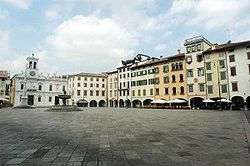
Piazza San Giacomo in Udine
-

The Miramare Castle in Trieste
-
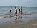
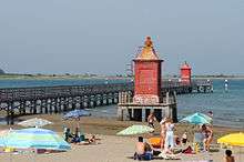
The Beach in Lignano Sabbiadoro
-

The Devil's Bridge in Cividale del Friuli
-
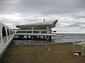
Terrazza Mare in Lignano Sabbiadoro
-
The Grado lagoon
-
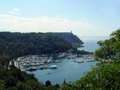
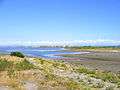
The bay of Sistiana
-
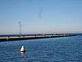
The sea in Trieste
-

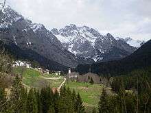
Sanctuary in Mount Lussari, Tarvisio
-
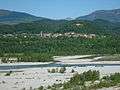
The Tagliamento river near Pinzano
-
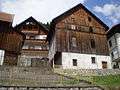
Typical houses in Carnia
External links
- Official site of the Autonomous Region of Friuli–Venezia Giulia (Italian), (Friulan), (Slovene), (German), (English)
- Official site of the Autonomous Region of Friuli–Venezia Giulia (German) (Slovene) (Friulian)
- fvg.INFO (Italian), (English), (German)
- Giro FVG - Rivista turistica, web, App iPhone, iPad, iPod del Friuli Venezia Giulia (Italian)
- Map of Friuli–Venezia Giulia
- "The official Website for tourism of Friuli–Venezia Giulia. Welcome". Friuli–Venezia Giulia. (Italian), (English), (German)
- Airport of Friuli–Venezia Giulia (Italian), (English), (Slovene)
- "meteo.fvg: Regione Autonoma Friuli–Venezia Giulia". OSMER: Osservatorio Meteorologico Regionale. (Italian), (Friulan), (Slovene), (German), (English)
| Provinces and places | | |
|---|---|---|
| History | ||
| Politics and government | ||
| Education and culture | ||
Categories | ||
Italy articles | ||||||||
|---|---|---|---|---|---|---|---|---|
| History |
|  | ||||||
| Geography | ||||||||
| Politics | ||||||||
| Economy | ||||||||
| Society |
| |||||||
| ||||||||