Dryden, Texas
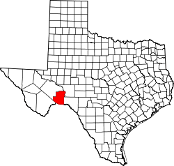
Dryden is an unincorporated community in south central Terrell County, Texas, United States.
History
The community was founded in 1882 and named for Eugene E. Dryden, the chief engineer of the Galveston, Harrisburg and San Antonio Railway, which was building its tracks through Terrell County and established a section house at Dryden. Over the next several decades Dryden became a small center for ranching-based businesses. The headquarters for the Pecos Land and Cattle Company was established in Dryden in 1884. The company drilled a well that supplied the area with water.
By 1912, a hotel, the Dryden Hotel, had been established, along with a combined schoolhouse, community center, and church. Dryden had a population of nearly 100 by 1929.
Two units of U.S. Army troops were stationed in Dryden during the 1913-1917 Mexican border unrest. During the Great Depression of the 1930s, the railway moved its crews and closed its depot at Dryden, and the area’s ranches were eventually broken up. Population began to dwindle to approximately fifty by 1970. Although a general store was operating in 1995, the population continued to decline to thirteen by 1988.[1][2]
The post office dates from 1888. The United States Postal Service currently maintains a post office in Dryden.[1]
Geography
Dryden is located on U.S. Route 90 at the intersection with State Highway 349, 100 miles (162 km) west of Del Rio. Its coordinates are Lat: 30.04444, Lon: -102.11417.[1][2][3]
Climate
- Coordinates: 30°03′00″N 102°07′00″W / 30.05000°N 102.11667°W
- Elevation: 2,190 feet (668 m)[4]
| Climate data for Dryden, Texas (Jun 1, 1966–Oct 31, 1994) | |||||||||||||
|---|---|---|---|---|---|---|---|---|---|---|---|---|---|
| Month | Jan | Feb | Mar | Apr | May | Jun | Jul | Aug | Sep | Oct | Nov | Dec | Year |
| Record high °F (°C) | 87 (31) |
95 (35) |
98 (37) |
103 (39) |
110 (43) |
112 (44) |
111 (44) |
110 (43) |
106 (41) |
103 (39) |
90 (32) |
87 (31) |
112 (44) |
| Average high °F (°C) | 60.2 (15.7) |
65.0 (18.3) |
74.3 (23.5) |
82.7 (28.2) |
88.8 (31.6) |
94.5 (34.7) |
95.5 (35.3) |
94.8 (34.9) |
88.8 (31.6) |
79.9 (26.6) |
69.2 (20.7) |
61.8 (16.6) |
79.6 (26.4) |
| Daily mean °F (°C) | 46.5 (8.1) |
50.5 (10.3) |
59.2 (15.1) |
68.1 (20.1) |
75.2 (24) |
81.5 (27.5) |
83.1 (28.4) |
82.1 (27.8) |
76.3 (24.6) |
66.3 (19.1) |
55.3 (12.9) |
47.8 (8.8) |
66.0 (18.9) |
| Average low °F (°C) | 32.7 (0.4) |
36.0 (2.2) |
44.0 (6.7) |
53.4 (11.9) |
61.6 (16.4) |
68.6 (20.3) |
70.6 (21.4) |
69.4 (20.8) |
63.8 (17.7) |
52.6 (11.4) |
41.7 (5.4) |
33.8 (1) |
52.3 (11.3) |
| Record low °F (°C) | 10 (−12) |
1 (−17) |
12 (−11) |
24 (−4) |
40 (4) |
49 (9) |
60 (16) |
59 (15) |
38 (3) |
27 (−3) |
17 (−8) |
1 (−17) |
1 (−17) |
| Average precipitation inches (mm) | 0.53 (13.5) |
1.03 (26.2) |
0.57 (14.5) |
0.99 (25.1) |
1.75 (44.4) |
1.02 (25.9) |
1.27 (32.3) |
1.85 (47) |
2.64 (67.1) |
1.40 (35.6) |
0.74 (18.8) |
0.45 (11.4) |
14.24 (361.7) |
| Average snowfall inches (cm) | 0.6 (1.5) |
0.2 (0.5) |
0.0 (0) |
0.0 (0) |
0.0 (0) |
0.0 (0) |
0.0 (0) |
0.0 (0) |
0.0 (0) |
0.0 (0) |
0.1 (0.3) |
0.0 (0) |
0.9 (2.3) |
| Average precipitation days (≥ 0.01 in) | 3 | 3 | 2 | 2 | 4 | 3 | 3 | 3 | 5 | 3 | 2 | 2 | 35 |
| Source: Western Regional Climate Center, Desert Research Institute[5] | |||||||||||||
Notes
- 1 2 3 "Dryden, Texas". TexasEscapes.com. 2007-06-04. Retrieved 2007-06-30.
- 1 2 "Dryden, Texas". Handbook of Texas Online. 2006-04-12. Retrieved 2007-06-30.
- ↑ "Dryden, Texas Community Profile". Home Town Locator. 2007. Retrieved 2007-06-30.
- ↑ "US COOP Station Map". Western Regional Climate Center, Desert Research Institute. Retrieved Mar 27, 2016.
- ↑ "DRYDEN, TEXAS (412590), Period of Record Monthly Climate Summary". Western Regional Climate Center, Desert Research Institute. Retrieved Mar 27, 2016.
Coordinates: 30°02′40″N 102°06′51″W / 30.04444°N 102.11417°W
Municipalities and communities of Terrell County, Texas, United States | ||
|---|---|---|
| CDP | | |
| Unincorporated community | ||