Dublin Township, Mercer County, Ohio
| Dublin Township, Mercer County, Ohio | |
|---|---|
| Township | |
|
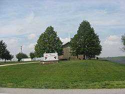
St. Theresa's Catholic Church | |
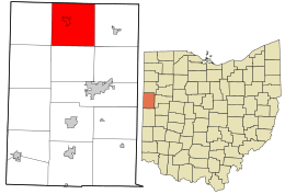 Location in Mercer County and the state of Ohio. | |
| Coordinates: 40°41′10″N 84°37′41″W / 40.68611°N 84.62806°WCoordinates: 40°41′10″N 84°37′41″W / 40.68611°N 84.62806°W | |
| Country | United States |
| State | Ohio |
| County | Mercer |
| Area | |
| • Total | 37.4 sq mi (96.9 km2) |
| • Land | 37.4 sq mi (96.8 km2) |
| • Water | 0.0 sq mi (0.0 km2) |
| Elevation[1] | 797 ft (243 m) |
| Population (2000) | |
| • Total | 2,254 |
| • Density | 60.3/sq mi (23.3/km2) |
| Time zone | Eastern (EST) (UTC-5) |
| • Summer (DST) | EDT (UTC-4) |
| FIPS code | 39-22708[2] |
| GNIS feature ID | 1086623[1] |
Dublin Township is one of the fourteen townships of Mercer County, Ohio, United States. The 2000 census found 2,254 people in the township, 1,128 of whom lived in the unincorporated portions of the township.[3]
Geography
Located in the northern part of the county, it borders the following townships:
- Liberty Township, Van Wert County - north
- York Township, Van Wert County - northeast corner
- Union Township - east
- Center Township - southeast corner
- Hopewell Township - south
- Liberty Township - southwest corner
- Black Creek Township - west
- Willshire Township, Van Wert County - northwest corner
The village of Rockford is located in central Dublin Township.
Name and history
Dublin Township was organized in 1824.[4] It is the only Dublin Township statewide.[5]
Government
The township is governed by a three-member board of trustees, who are elected in November of odd-numbered years to a four-year term beginning on the following January 1. Two are elected in the year after the presidential election and one is elected in the year before it. There is also an elected township fiscal officer,[6] who serves a four-year term beginning on April 1 of the year after the election, which is held in November of the year before the presidential election. Vacancies in the fiscal officership or on the board of trustees are filled by the remaining trustees.
References
- 1 2 "US Board on Geographic Names". United States Geological Survey. 2007-10-25. Retrieved 2008-01-31.
- ↑ "American FactFinder". United States Census Bureau. Retrieved 2008-01-31.
- ↑ Mercer County, Ohio — Population by Places Estimates Ohio State University, 2007. Accessed 15 May 2007.
- ↑ Scranton, S. S. (1907). History of Mercer County, Ohio, and Representative Citizens. Biographical Publishing Company. p. 138.
- ↑ "Detailed map of Ohio" (PDF). United States Census Bureau. 2000. Retrieved 2007-02-16.
- ↑ §503.24, §505.01, and §507.01 of the Ohio Revised Code. Accessed 4/30/2009.
External links
Municipalities and communities of Mercer County, Ohio, United States | ||
|---|---|---|
| City | 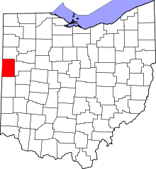 | |
| Villages | ||
| Townships | ||
| Unincorporated communities | ||
| Footnotes | ‡This populated place also has portions in an adjacent county or counties | |