Milngavie
| Milngavie | |
| Scottish Gaelic: Muileann-Gaidh | |
| Scots: Mulguye | |
 Friendship House, Milngavie St. Andrew's Episcopal Church |
|
 Milngavie |
|
| Population | 12,795 |
|---|---|
| OS grid reference | NS553744 |
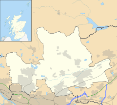
| Council area | East Dunbartonshire |
| Lieutenancy area | Dunbartonshire |
| Country | Scotland |
| Sovereign state | United Kingdom |
| Post town | GLASGOW [1] |
| Postcode district | G62 |
| Dialling code | 0141 |
| Police | Scottish |
| Fire | Scottish |
| Ambulance | Scottish |
| EU Parliament | Scotland |
| UK Parliament | East Dunbartonshire |
| Scottish Parliament | Clydebank and Milngavie |
Coordinates: 55°56′32″N 4°18′49″W / 55.9421°N 4.3137°W
Milngavie ![]() i/mᵻlˈɡaɪ/, məl-GUY (Scots: Mulguye,[2] Scottish Gaelic: Muileann-Gaidh[3]) is a town in East Dunbartonshire, Scotland. It is on the Allander Water, at the northwestern edge of Greater Glasgow, and about 6 miles (10 km) from Glasgow city centre. It neighbours Bearsden.
i/mᵻlˈɡaɪ/, məl-GUY (Scots: Mulguye,[2] Scottish Gaelic: Muileann-Gaidh[3]) is a town in East Dunbartonshire, Scotland. It is on the Allander Water, at the northwestern edge of Greater Glasgow, and about 6 miles (10 km) from Glasgow city centre. It neighbours Bearsden.
Milngavie is a commuter town, with much of its working population travelling to Glasgow to work or study. The town is served by Milngavie railway station on the North Clyde Line of the SPT rail network, which links it to Central Glasgow. The town is also a very popular retirement location, with an unusually high proportion of elderly. In the 2001 census the town had a population of 12,795 in 5,256 households.
The Milngavie and Bearsden Herald, owned by Johnston Press, is a weekly newspaper that covers local events from the schools, town halls, community and government in the area. The paper was established in 1901 and is printed every Wednesday, to be sold on Thursdays.
Currently the town is perhaps best known as the start of the West Highland Way long distance footpath which runs northwards for 95 miles (153 km) to the town of Fort William. A granite obelisk in the town centre marks the official starting point of the footpath.
History
The apparent mismatch between the town's written and pronounced names stems from the way its Gaelic name was adapted into English. The Gaelic name for the town is conjectured to have been Muileann Dhaibhidh (Scottish Gaelic pronunciation: [ˌmulan̪ˠ ˈɣaivi];[4] "David's mill"[5][6]), with Daibhidh shortened to Dàidh in common speech,[7] yielding Muileann Dhàidh ([ˌmulan̪ˠ ˈɣai]). The former may thus account for the spelling "-gavie", the latter for the pronunciation "-guy". The stress placement is Gaelic, too, but the first part of the name may have been influenced by its Scots/English counterpart[8] in both pronunciation and spelling, not just reduced; cf. Kirkcudbright.
There are many Scots names for the town. In fact, even within single texts such as the Records of the Parliament of Scotland, different variants are used alongside each other (Mylnedavie, Mylnegaivie, Milnegaivie and Milngaivie).[9] Joan Blaeu's Atlas of Scotland shows some Scots spellings for well-known places which indicate some of their origins: Milngavie is shown as Milgay ("ay" being a Scots spelling of [ae̯], cf. aye and the original pronunciation of MacKay), possibly meaning "Mill of Guy".[10] An alternative suggestion is that the original translation meant "Gavin's Mill", and indeed Gavin's Mill remains in the town centre to this day. The most recently published name is Mulguy, although the author (Billy Kay) admits that while academically researched, some entries in his work on place names may be controversial.[11]
Although known today as a dormitory suburb of Glasgow, the town grew from a country village within the parish of New Kilpatrick to a minor industrial centre in the nineteenth century with paper mills and bleach works on the Allander River to the north east of the town centre. Some remnants of this industry remain today on the Clober Industrial Estate.
The land surrounding the village comprised several estates with tenant farms, amongst them Barloch, Clober, Craigton, Craigdhu, Dougalston, Douglas Mains and South Mains.
Stone built villas and semi detached houses were constructed for wealthy citizens to the east of the town centre and around Tannoch Loch when commuting to Glasgow was made possible by the opening of the railway which reached the town in 1863. After World War II a local authority housing scheme was built to the west of the town centre, housing many people relocated from Clydebank which had been badly bombed. The town grew with the addition of private speculative housing developments of bungalows and semi-detached homes at South Mains to the south of the town centre and around Clober, to the west, in the 1950s and 1960s. The Fairways estate was built, starting in 1978 and continued into the 1980s.
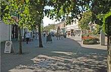
The town centre was redeveloped to improve traffic flow and pedestrian safety. The central commercial streets were pedestrianised starting in 1974 and many buildings replaced. A superstore was opened on the fringes of the town centre in the 1990s.
Residents launched a "tongue in cheek" campaign to bring the Olympic games to Milngavie in 2020.[12]
Governance
Milngavie, originally in Stirlingshire, was in an area that became an exclave of Dunbartonshire on the orders of King David II (1324 - 1371). In 1875, whilst remaining part of Dunbartonshire, it became a police burgh under the jurisdiction of the Stirlingshire constabulary and retained burgh status for 100 years until 1975 when it was absorbed into the newly created Strathclyde Region.
Milngavie is located to the north of the neighbouring town of Bearsden. Although the two are in close proximity, the social histories of these two towns differ significantly. Bearsden grew almost exclusively as a dormitory town of Glasgow for the wealthy and professional classes. In that sense both towns now fulfil a similar role. The two became a single local authority district in 1975, before Scottish Local Government reorganisation in the 1990s re-integrated them with Kirkintilloch and Bishopbriggs to form the East Dunbartonshire administrative area, although transport and social networks link the town much more closely with Glasgow itself.
Certain properties in the locale can command some of the highest house prices in the greater Glasgow urban area. This has led to its reputation as an exclusive residential area and an aspirational destination for home buyers.
Governmental and tax raising boundaries separate Milngavie and Bearsden, along with other wealthy dormitory towns like Newton Mearns and Giffnock, from the City of Glasgow unitary authority area.
Landmarks
.jpg)
Little remains of the pre-nineteenth century village other than the Corbie Ha' meeting hall, Cross Keys Public House and the Gavin's Mill water mill on the Allander Water along with Barloch House and Barloch Farm.
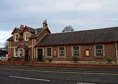
There are a few good examples of nineteenth century stone villas along the Station Road as well as the well preserved nineteenth century railway station. Many interesting Victorian houses around the Tannoch Conservation Area show Scottish cottage, Scottish Baronial, Classical architecture and Gothic influences. The town centre and Strathblane Road have remaining Victorian shop/tenement buildings and a few Arts and crafts influenced commercial buildings. Craigmillar Avenue and the area around Baldernock Road have some large Arts and Crafts and Glasgow Style influenced houses.

The bulk of the housing stock is twentieth century, showing Scottish vernacular influences such as harling or rough-casting, and, occasionally, more traditionally English elements like black and white timber paneled dormer windows and gables.
The public sheltered housing projects of the 1970s and 1980s are interesting for their attempts to use traditional local materials like grey rough-cast and slate plus interesting rounded walls and pitched roofs.
The most recent development is characterised by some interesting one-off conversions and extensions to Victorian properties; new housing by developers that often follows designs based on the brick architecture of the South of England; and contemporary steel framed commercial and leisure buildings.
The Milngavie reservoir is visited by tourists and walkers. The reservoir is made up of the Craigmaddie and Mugdock reservoirs and was opened in 1859 by Queen Victoria.[13] It is the main supplier of water to the city of Glasgow and can hold up to 548 million gallons of water.
The war memorial is by George Henry Paulin.
The Auld Wives' Lifts, an interesting natural rock feature, is located on Craigmaddie Muir to the north east of Milngavie.[14]
Education
Secondary schools
- Douglas Academy : A state-funded secondary school, which includes a Music School for gifted children who gain entry through audition and board in Glasgow's West End
Primary schools
State funded:
- Clober Primary
- Craigdhu Primary
- Milngavie Primary
- St Joseph's Primary is a state-funded Roman Catholic school.
Privately funded:
- The Glasgow Academy Milngavie is a fee paying Nursery and Primary School that is part of The Glasgow Academy, whose senior school and other departments are located at Colebrooke Street in the West End of Glasgow.
Places of worship
- Allander Evangelical Church
- Cairns Church of Scotland
- Milngavie United Free Church of Scotland
- St. Andrew's Episcopal Church
- St. Joseph's Roman Catholic Church
- St. Luke's Church of Scotland
- St. Paul's Church of Scotland
Originally Milngavie was in the Parish of New Kilpatrick, the church being that of New Kilpatrick in Bearsden, with no formal place of worship in the town until the eighteenth century. Milngavie has three stone built churches dating from the early twentieth century within 500 m of each other. Up until the 1970s these three were all Church of Scotland congregations: St.Paul's, Cairns, and St.Luke's. This came about due to the history of the Kirk (Church of Scotland) which saw a multitude of factions and congregations organise, each with varying forms of worship and constitutional arrangements, which subsequently re-integrated. St.Paul's was always in the fold of the Church of Scotland and is the parish church of Milngavie. It was originally housed in a simple grey stone church building above the Station Road beside the Milngavie Primary School before moving to a handsome red sandstone building on the Strathblane Road in 1906. The original building is now apartments. Since 1799 Cairns Church had been located in a building on Mugdock Road close to the 'preaching braes' on Barloch Moor where the congregation's first services had taken place. It moved to its present building on Buchanan Street in 1903 which displays elements of the Glasgow Style of architecture and design. St.Luke's had been built as the Milngavie United Free Church. In the 1970s it was decided that the concentration of churches in one area should be reviewed and a new St. Lukes was built on the western side of the town to serve the residents of Clober. The Roman Catholic Church bought the old St.Luke's Church and moved their congregation to the new premises from a chapel on Buchanan Street at Moor Road which was associated with the neighbouring Roman Catholic Convent of Ladywood which closed in the 1970s.
Sporting institutions
Milngavie is the base of West of Scotland F.C., a rugby club, which dates from 1865 and is one of the founder members of the SRU. They were one of the first open rugby clubs in Scotland, i.e. not affiliated to any school.
Rangers F.C. has its professional training facility at Auchenhowie Road in the east of the town.
Due to the town's suburban and residential profile, it is home to many sporting clubs and facilities.
- Allander Leisure Centre
- Milngavie Bowling Club
- Claremont Bowling Club
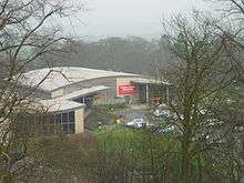 Virgin Active Milngavie. Previously Esporta Health Clubs
 - Clober Golf Club
- Milngavie Golf Club
- Milngavie Wanderers AFC
- Virgin Active Golf and Fitness Club
- Hilton Park Golf Club
- Glasgow Vipers Inline Hockey Club
- Sports Direct Fitness.com (formerly LA Fitness)
- Milngavie Lawn Tennis Club
- Western Wildcats Hockey Club
- Milngavie Boys Club
- Milngavie and Bearsden Amateur Swimming Club
Notable people
The playwright Robert McLellan grew up in the town where his father, John, founded and ran the local Allander Press, with premises in the Black Bull Yard from c.1912.
The footballer Murdo MacLeod, who played for Dumbarton, Celtic, Borussia Dortmund and Hibernian, and at international level for Scotland, was born and brought up in Milngavie.
Author Marie Clare Friar, who wrote Love So Sweet, was raised in Milngavie and had her first book signing in the local book shop, and officially opened St Joseph's Primary School Library (her former primary school). The Liberal Democrat politician Jo Swinson was born and brought up in Milngavie. She attended local school Douglas Academy. She is the former Parliamentary Under Secretary of State for Employment relations, consumer and postal affairs, having lost her seat in the 2015 General Election.[15]
Prof Edward Eisner FRSE of the University of Strathclyde lived in Milngavie.[16]
See also
- Milngavie water treatment works
- Bennie Railplane
- List of places in East Dunbartonshire
- List of places in Scotland
References
- ↑ Evox Facilities. "List of UK post towns". Evox Facilities. Retrieved 2012-02-22.
- ↑ List of railway station names English, Gaelic and Scots Archived January 22, 2013, at the Wayback Machine.
- ↑ "Ainmean-Àite na h-Alba". Gaelic Place-Names of Scotland. Retrieved 2016-08-21.
- ↑ "Archived copy" (PDF). Archived from the original (PDF) on 2011-09-28. Retrieved 2011-06-19.
- ↑ "Rannsaich an Stòr-dàta Briathrachais Gàidhlig" (in Scottish Gaelic). .smo.uhi.ac.uk. 2010-11-10. Retrieved 2012-02-01.
- ↑ "Am Faclair Beag - Scottish Gaelic Dictionary". Am Faclair Beag. Retrieved 2012-02-01.
- ↑ MacBain, LL.D., Alexander (1911). "An Etymological Dictionary of the Gaelic Language". Stirling. p. 399.
- ↑ "Archived copy". Archived from the original on 2012-03-21. Retrieved 2011-06-19.
- ↑ "The Records of the Parliaments of Scotland to 1707 - Ratificatioune in favouris of the lord marques of Argyll". St Andrews University. 1649-03-16. Retrieved 2011-11-01.
- ↑ McCardel, J (1949). The Parish of New Kilpatrick. University Press Glasgow.
- ↑ "Now Mulguy won't put tourists in a tizz". The Herald. 1993-12-03. Retrieved 2011-11-01.
- ↑ "Milngavie bids to host Olympics". BBC News. 2008-04-11. Retrieved 2009-07-30.
- ↑ "Glasgow Corporation Waterworks, Milngavie, Craigmaddie Reservoir". Canmore.rcahms.gov.uk. 2003-04-02. Retrieved 2016-08-21.
- ↑ "The Auld Wives' Lifts" (PDF). Education Scotland. Retrieved 21 August 2013.
- ↑ Cohen, Tamara (2014-01-06). "Lib Dem Jo Swinson says ban on bringing infants to voting lobby is 'bizarre'". Daily Mail Online. Retrieved 2016-08-21.
- ↑ BIOGRAPHICAL INDEX OF FORMER FELLOWS OF THE ROYAL SOCIETY OF EDINBURGH 1783 – 2002 (PDF). The Royal Society of Edinburgh. July 2006. ISBN 0 902 198 84 X.