Dutch Caribbean
|
| |
|
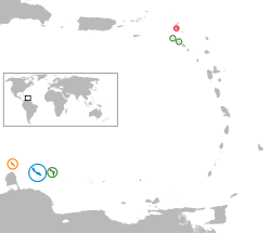
Location of the Dutch Caribbean islands
| |
| Area | 999 km2 (386 sq mi) |
|---|---|
| Population (2010) | 315,339 |
| GDP (Nominal) | US$ 8.911 billion[1] |
| GDP per Capita (Nominal) | US$ 29,240[1] |
| Density | 305/km2 (790/sq mi) |
| Languages | Dutch, English, Papiamento |
| Government |
3 countries 3 special municipalities |

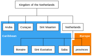
The Dutch Caribbean refers to territories, colonies and countries, both former and current, of the Kingdom of the Netherlands that are located in the Lesser Antilles archipelago of the Caribbean Sea. Current territories comprise the islands of Aruba, Curaçao, Sint Maarten, Bonaire, Sint Eustatius and Saba. The term may sometimes also be used interchangeably with the term Caribbean Netherlands to refer to just three of those islands (Bonaire, Sint Eustatius and Saba) which are special municipalities of the Netherlands proper.[2][3]
All of the islands in the Dutch Caribbean were, at some point in their history, part of the constituent country of the Netherlands Antilles and its predecessor, the colony of Curaçao and Dependencies. By contrast, the former Dutch colony of Suriname was not considered to be part of Dutch Caribbean, although it was relatively close by on the continent of South America.
History
The island of Aruba seceded from the Netherlands Antilles in 1986 to become a separate constituent country of the Kingdom of the Netherlands, leaving only five island territories within the Netherlands Antilles. This situation remained until the complete dissolution of the Netherlands Antilles as a unified political entity in 2010, when Curaçao and Sint Maarten became autonomous constituent countries within the Kingdom like Aruba, while Bonaire, Sint Eustatius, and Saba became special municipalities of the Netherlands proper. Before the dissolution, the autonomy of the island areas was specified in the Islands Regulation of the Netherlands Antilles.
Currently, there are two main divisions in the Dutch Caribbean:
- those islands that have the status of being constituent countries of the Kingdom of the Netherlands
- those islands that have the status of being special municipalities of the Netherlands alone, as distinct from the Kingdom in its entirety.
Constituent countries
There are three Caribbean islands that are countries (Dutch: landen) within the Kingdom of the Netherlands: Aruba, Curaçao, and Sint Maarten. The Netherlands is the fourth and largest constituent country in the Kingdom.
Sint Maarten comprises approximately one half of the island of Saint Martin. The northern half of the island – the Collectivity of Saint Martin – is an overseas territory of France.
Special municipalities
There are three Caribbean islands that are special municipalities of the Netherlands alone: Bonaire, Sint Eustatius, and Saba. Collectively, these special municipalities of the Netherlands are also known as the "BES islands" or "Caribisch Nederland" (Caribbean Netherlands).
Comparison
| Territory | Population | Area (square km) |
|---|---|---|
| Aruba | 103,400 | 179 |
| Bonaire | 17,408 | 294 |
| Curaçao | 158,986 | 444 |
| Saba | 1,991 | 13 |
| Sint Eustatius | 4,020 | 32 |
| Sint Maarten | 33,609 | 37 |
Grouping of islands
The islands have also been informally grouped in the following ways:
- ABC islands, for Aruba, Bonaire, and Curaçao;
- BES islands, for Bonaire, Sint Eustatius, and Saba;
- SSS islands, for Saba, Sint Eustatius, and Sint Maarten.
-

Map of the Dutch Caribbean islands.
-
Those countries and special municipalities of the Kingdom of the Netherlands that are located in the Caribbean (blue background) form the Dutch Caribbean.
References
- 1 2 COUNTRY COMPARISON GDP, Central Intelligence Agency.
- ↑ "Rijksdienst Carbische Nederland (Rijksdienst Dutch Caribbean)". Government of the Netherlands. Retrieved 4 June 2015.
- ↑ "Visa for the Dutch Caribbean". Netherlands Embassy in the United Kingdom. Retrieved 4 June 2015.
External links
 Media related to Dutch Caribbean at Wikimedia Commons
The Netherlands Antilles was dissolved on 10 October 2010 1Aruba seceded from the Netherlands Antilles on 1 January 1986 | ||