Aruba
| Aruba |
||||||
|---|---|---|---|---|---|---|
|
||||||
| Anthem: Aruba Dushi Tera Aruba, Sweet Land  |
||||||
 |
||||||
| Capital and largest city | Oranjestad 12°31′N 70°2′W / 12.517°N 70.033°W | |||||
| Official languages | ||||||
| Ethnic groups | ||||||
| Demonym | Aruban | |||||
| Sovereign state | ||||||
| Government | Unitary parliamentary representative democracy under constitutional monarchy | |||||
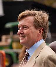
| • | Monarch | Willem-Alexander | ||||
| • | Governor | Fredis Refunjol | ||||
| • | Prime Minister | Mike Eman | ||||
| Legislature | Estates of Aruba | |||||
| Autonomy from the Netherlands Antilles | ||||||
| • | Date | 18 March 1986 | ||||
| Area | ||||||
| • | Total | 178.91 km2 69.08 sq mi |
||||
| • | Water (%) | negligible | ||||
| Population | ||||||
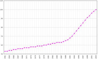
| • | 2014 estimate | 103,400 [2] (197th) | ||||
| • | Density | 612/km2 (22nd) 1,489.79/sq mi |
||||
| GDP (PPP) | 2011 estimate | |||||
| • | Total | US$2.616 billion[3] (190th) | ||||
| • | Per capita | US$25,300 (47th) | ||||
| GDP (nominal) | 2013[4] estimate | |||||
| • | Total | US$2.991 billion (162nd) | ||||
| • | Per capita | US$28,924 (32nd) | ||||
| HDI (2013) | 0.825 very high |
|||||
| Currency | Aruban florin (AWG) | |||||
| Time zone | AST (UTC−4) | |||||
| Drives on the | right | |||||
| Calling code | +297 | |||||
| ISO 3166 code | AW | |||||
| Internet TLD | .aw | |||||
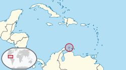
Aruba (/əˈruːbə/ ə-ROO-bə; Dutch: [aːˈrubaː]) is a constituent country of the Kingdom of the Netherlands in the southern Caribbean Sea, located about 1,600 kilometres (990 mi) west of the main part of the Lesser Antilles and 29 kilometres (18 mi)[5] north of the coast of Venezuela. It measures 32 kilometres (20 mi) long from its northwestern to its southeastern end and 10 kilometres (6 mi) across at its widest point.[5] Together with Bonaire and Curaçao, Aruba forms a group referred to as the ABC islands. Collectively, Aruba and the other Dutch islands in the Caribbean are often called the Dutch Caribbean.
Aruba is one of the four countries that form the Kingdom of the Netherlands, along with the Netherlands, Curaçao and Sint Maarten. The citizens of these countries all share a single nationality: Dutch. Aruba has no administrative subdivisions, but, for census purposes, is divided into eight regions. Its capital is Oranjestad.
Unlike much of the Caribbean region, Aruba has a dry climate and an arid, cactus-strewn landscape. This climate has helped tourism as visitors to the island can reliably expect warm, sunny weather. It has a land area of 179 km2 (69.1 sq mi) and is densely populated, with a total of 102,484 inhabitants at the 2010 Census. It lies outside Hurricane Alley.
History

Aruba's first inhabitants are thought to have been Caquetío Amerindians from the Arawak tribe, who migrated there from Venezuela to escape attacks by the Caribs. Fragments of the earliest known Indian settlements date back to 1000 AD. As sea currents made canoe travel to other Caribbean islands difficult, Caquetio culture remained more closely associated with that of mainland South America.
Europeans first learned of Aruba following the explorations for Spain by Amerigo Vespucci and Alonso de Ojeda in the summer of 1499. Both described Aruba as an "island of giants", remarking on the comparatively large stature of the native Caquetíos compared to Europeans. Gold was not discovered on Aruba for another 300 years. Vespucci returned to Spain with stocks of cotton and brazilwood from the island and described houses built into the ocean. Vespucci and Ojeda's tales spurred interest in Aruba, and Spaniards soon colonized the island.[6][7]
Because it had low rainfall, Aruba was not considered profitable for the plantation system and the economics of the slave trade.
Aruba was colonized by Spain for over a century. Simas, the Cacique, or chief, in Aruba, welcomed the first Catholic priests in Aruba, who gave him a wooden cross as a gift. In 1508, the Spanish Crown appointed Alonso de Ojeda as its first Governor of Aruba, as part of Nueva Andalucía. Arawaks spoke the "broken Spanish" which their ancestors had learned on Hispaniola.
Another governor appointed by Spain was Juan Martínez de Ampiés. A cédula real decreed in November 1525 gave Ampiés, factor of Española, the right to repopulate Aruba. In 1528, Ampiés was replaced by a representative of the House of Welser.
The Dutch statutes have applied to Aruba since 1629. The Netherlands acquired Aruba in 1636. Since 1636, Aruba has been under Dutch administration, initially governed by Peter Stuyvesant, later appointed to New Amsterdam (New York City). Stuyvesant was on a special mission in Aruba in November and December 1642. The island was included under the Dutch West India Company (W.I.C.) administration, as "New Netherland and Curaçao", from 1648 to 1664. In 1667 the Dutch administration appointed an Irishman as "Commandeur" in Aruba.
The Dutch took control 135 years after the Spanish, leaving the Arawaks to farm and graze livestock, and used the island as a source of meat for other Dutch possessions in the Caribbean.
During the Napoleonic wars, the British Empire took control over the island, between 1799 and 1802, and between 1804 and 1816, before handing it back to the Dutch.[8]
During World War II with the occupation of the Netherlands in 1940 the oil facilities in Aruba came under the administration of the Dutch government-in-exile in London, and Aruba continued to supply oil to the British and their allies.
Move towards independence
In August 1947, Aruba presented its first Staatsreglement (constitution), for Aruba's status aparte as an autonomous state within the Kingdom of the Netherlands. By 1954, the Charter of the Kingdom of the Netherlands was established, providing a framework for relations between Aruba and the rest of the Kingdom.[9]
In 1972, at a conference in Suriname, Betico Croes (MEP), a politician from Aruba, proposed a sui-generis Dutch Commonwealth of four states: Aruba, the Netherlands, Suriname and the Netherlands Antilles, each to have its own nationality. C. Yarzagaray, a parliamentary member representing the AVP political party, proposed a referendum so that the people of Aruba could choose whether they wanted total independence or Status Aparte as a full autonomous state under the Crown.
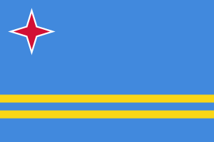
Croes worked in Aruba to inform and prepare the people of Aruba for independence. In 1976, he appointed a committee that chose the national flag and anthem, introducing them as symbols of Aruba's sovereignty and independence. He set 1981 as a target date for independence. In March 1977, the first Referendum for Self Determination was held with the support of the United Nations; 82% of the participants voted for independence.[10]
The Island Government of Aruba assigned the Institute of Social Studies in The Hague to prepare a study for independence; it was titled Aruba en Onafhankelijkheid, achtergronden, modaliteiten en mogelijkheden; een rapport in eerste aanleg (Aruba and independence, backgrounds, modalities and opportunities; a preliminary report) (1978). At the conference in The Hague in 1981, Aruba's independence was set for the year 1991.
In March 1983, Aruba reached an official agreement within the Kingdom for its independence, to be developed in a series of steps as the Crown granted increasing autonomy. In August 1985 Aruba drafted a constitution that was unanimously approved. On 1 January 1986, after elections were held for its first parliament, Aruba seceded from the Netherlands Antilles; it officially became a country of the Kingdom of the Netherlands. Full independence was projected in 1996.
After his death in 1986, Croes was proclaimed Libertador di Aruba. At a convention in The Hague in 1990, at the request of Aruba's Prime Minister, the governments of Aruba, the Netherlands, and the Netherlands Antilles postponed indefinitely its transition to full independence. The article scheduling Aruba's complete independence was rescinded in 1995, although the process could be revived after another referendum.
Geography


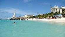
Aruba is a generally flat, riverless island in the Leeward Antilles island arc of the Lesser Antilles in the southern part of the Caribbean. It has white sandy beaches on the western and southern coasts of the island, relatively sheltered from fierce ocean currents.[11] This is where most tourist development has occurred.[11] The northern and eastern coasts, lacking this protection, are considerably more battered by the sea and have been left largely untouched by humans.
The hinterland of the island features some rolling hills, the best known of which are called Hooiberg at 165 meters (541 ft) and Mount Jamanota, the highest on the island at 188 meters (617 ft) above sea level. Oranjestad, the capital, is located at 12°19′N 70°1′W / 12.317°N 70.017°W.
To the east of Aruba are Bonaire and Curaçao, two island territories which once formed the southwest part of the Netherlands Antilles. This group of islands is sometimes called the ABC islands. They are located on the South American continental shelf and therefore geographically listed as part of South America.
The Natural Bridge was a large, naturally formed limestone bridge on the island's north shore. It was a popular tourist destination until its collapse in 2005.
Cities and towns
The island, with a population of just over 100,000 inhabitants, does not have major cities. However, most of the island's population resides in or surrounding the two major city-like districts of Oranjestad (Capital) and San Nicolaas. Furthermore, the island is divided into six districts, which are:
- Noord
- Oranjestad (33,000 in 2006), divided in two districts
- Paradera
- San Nicolaas, divided in two districts
- Santa Cruz
- Savaneta
Fauna
The island of Aruba, being isolated from the main land of South America, has helped the evolution of multiple endemic animals. The island provides a habitat for the endemic Aruban Whiptail and Aruba Rattlesnake, as well as endemic subspecies of Burrowing Owl and Brown-throated Parakeet.
The rattlesnake and the owl are printed on the Aruban currency.
Flora
The flora of Aruba differs from the typical tropical island vegetation. Xeric scrublands are common, with various forms of cacti, thorny shrubs and evergreens. With the most known plant being the Aloe vera, which has a place on the Coat of Arms of Aruba.
Climate
In the Köppen climate classification, Aruba has a tropical semi-arid climate.[12] Mean monthly temperature in Oranjestad varies little from 26.7 °C (80.1 °F) to 29.2 °C (84.6 °F), moderated by constant trade winds from the Atlantic Ocean, which comes from north-east. Yearly precipitation barely exceeds 470 mm (18.5 in) in Oranjestad.
| Climate data for Oranjestad, Aruba (1981–2010, extremes 1951–2010) | |||||||||||||
|---|---|---|---|---|---|---|---|---|---|---|---|---|---|
| Month | Jan | Feb | Mar | Apr | May | Jun | Jul | Aug | Sep | Oct | Nov | Dec | Year |
| Record high °C (°F) | 32.5 (90.5) |
33.0 (91.4) |
33.9 (93) |
34.4 (93.9) |
34.9 (94.8) |
35.2 (95.4) |
35.3 (95.5) |
36.1 (97) |
36.5 (97.7) |
35.4 (95.7) |
35.0 (95) |
34.8 (94.6) |
36.5 (97.7) |
| Average high °C (°F) | 30.0 (86) |
30.4 (86.7) |
30.9 (87.6) |
31.5 (88.7) |
32.0 (89.6) |
32.2 (90) |
32.0 (89.6) |
32.6 (90.7) |
32.7 (90.9) |
32.1 (89.8) |
31.3 (88.3) |
30.4 (86.7) |
31.5 (88.7) |
| Daily mean °C (°F) | 26.7 (80.1) |
26.8 (80.2) |
27.2 (81) |
27.9 (82.2) |
28.5 (83.3) |
28.7 (83.7) |
28.6 (83.5) |
29.1 (84.4) |
29.2 (84.6) |
28.7 (83.7) |
28.1 (82.6) |
27.2 (81) |
28.1 (82.6) |
| Average low °C (°F) | 24.5 (76.1) |
24.7 (76.5) |
25.0 (77) |
25.8 (78.4) |
26.5 (79.7) |
26.7 (80.1) |
26.4 (79.5) |
26.8 (80.2) |
26.9 (80.4) |
26.4 (79.5) |
25.8 (78.4) |
25.0 (77) |
25.9 (78.6) |
| Record low °C (°F) | 21.3 (70.3) |
20.6 (69.1) |
21.4 (70.5) |
21.5 (70.7) |
21.8 (71.2) |
22.7 (72.9) |
21.2 (70.2) |
21.3 (70.3) |
22.1 (71.8) |
21.9 (71.4) |
22.0 (71.6) |
20.5 (68.9) |
20.5 (68.9) |
| Average precipitation mm (inches) | 39.3 (1.547) |
20.6 (0.811) |
8.7 (0.343) |
11.6 (0.457) |
16.3 (0.642) |
18.7 (0.736) |
31.7 (1.248) |
25.8 (1.016) |
45.5 (1.791) |
77.8 (3.063) |
94.0 (3.701) |
81.8 (3.22) |
471.8 (18.575) |
| Average precipitation days (≥ 1.0 mm) | 8.4 | 5.0 | 1.8 | 1.9 | 2.2 | 2.8 | 4.9 | 4.3 | 3.9 | 7.4 | 10.6 | 11.4 | 64.6 |
| Average relative humidity (%) | 77.5 | 76.1 | 75.7 | 77.1 | 77.9 | 77.4 | 77.8 | 76.2 | 76.8 | 78.6 | 79.1 | 78.4 | 77.4 |
| Source: DEPARTAMENTO METEOROLOGICO ARUBA,[13] (extremes)[12] | |||||||||||||
Demographics
The population is estimated to be 75% mixed European/Amerindian/African, 15% Black and 10% other ethnicities.
The Arawak heritage is stronger on Aruba than on most Caribbean islands. Although no full-blooded Aboriginals remain, the features of the islanders clearly indicate their genetic Arawak heritage. Most of the population is descended from Caquetio Indians and Dutch and to a lesser extent of Africans, Spanish, Portuguese, English, French, and Sephardic Jewish ancestors.
Recently, there has been substantial immigration to the island from neighboring American and Caribbean nations, possibly attracted by the higher paid jobs. In 2007, new immigration laws were introduced to help control the growth of the population by restricting foreign workers to a maximum of three years residency on the island.
Demographically, Aruba has felt the impact of its proximity to Venezuela. Many of Aruba's families are descended from Venezuelan immigrants. There is a seasonal increase of Venezuelans living in second homes.
Language
The official languages are Dutch and – since 2003 – Papiamento. Papiamento is the predominant language on Aruba. It is a creole language, spoken on Aruba, Bonaire, and Curaçao, that incorporates words from Portuguese, West African languages, Dutch, and Spanish. English is known by many; its usage has grown due to tourism. Other common languages spoken, based on the size of their community, are Portuguese, Chinese, German, Spanish, and French.
In recent years, the government of Aruba has shown an increased interest in acknowledging the cultural and historical importance of its native language. Although spoken Papiamento is fairly similar among the several Papiamento-speaking islands, there is a big difference in written Papiamento. The orthography differs per island and even per group of people. Some are more oriented towards Portuguese and use the equivalent spelling (e.g. "y" instead of "j"), where others are more oriented towards Dutch.
The book The Buccaneers of America, first published in 1678, states through eyewitness account that the natives on Aruba spoke "Spanish". The oldest government official statement written in Papiamento dates from 1803. Around 12.6% of the population today speaks Spanish.[14]
Aruba has four newspapers published in Papiamento: Diario, Bon Dia, Solo di Pueblo and Awe Mainta; and three in English: Aruba Daily, Aruba Today and The News. Amigoe is a newspaper published in Dutch. Aruba also has 18 radio stations (two AM and 16 FM) and three local television stations (Telearuba, Aruba Broadcast Company and Channel 22).
Regions
For census purposes, Aruba is divided into eight regions, which have no administrative functions:
| Name | Area (km²) | Population 1991 Census | Population 2000 Census | Population 2010 Census |
|---|---|---|---|---|
| Noord / Tanki Leendert | 34.62 | 10,056 | 16,944 | 21,495 |
| Oranjestad West | 9.29 | 8,779 | 12,131 | 13,976 |
| Oranjestad Oost | 12.88 | 11,266 | 14,224 | 14,318 |
| Paradera | 20.49 | 6,189 | 9,037 | 12,024 |
| San Nicolas Noord | 23.19 | 8,206 | 10,118 | 10,433 |
| San Nicolas Zuid | 9.64 | 5,304 | 5,730 | 4,850 |
| Santa Cruz | 41.04 | 9,587 | 12,326 | 12,870 |
| Savaneta | 27.76 | 7,273 | 9,996 | 11,518 |
| Total Aruba | 178.91 | 66,687 | 90,506 | 101,484 |
Government

.jpg)

As a constituent country of the Kingdom of the Netherlands, Aruba's politics take place within a framework of a 21-member Parliament and an eight-member Cabinet. The governor of Aruba is appointed for a six-year term by the monarch, and the prime minister and deputy prime minister are elected by the Staten (or "Parlamento") for four-year terms. The Staten is made up of 21 members elected by direct, popular vote to serve a four-year term.[15]
Together with the Netherlands, the countries of Aruba, Curaçao and Sint Maarten form the Kingdom of the Netherlands. As they share the same Dutch citizenship, these four countries still also share the Dutch passport as the Kingdom of the Netherlands passport. As Aruba, Curaçao and Sint Maarten have small populations, the three countries had to limit immigration. To protect their population, they have the right to control the admission and expulsion of people from the Netherlands.
Aruba is designated as a member of the Overseas Countries and Territories (OCT) and is thus officially not a part of the European Union, though Aruba can and does receive support from the European Development Fund.[16][17]
Politics
The Aruban legal system is based on the Dutch model. In Aruba, legal jurisdiction lies with the Gerecht in Eerste Aanleg (Court of First Instance) on Aruba, the Gemeenschappelijk Hof van Justitie van Aruba, Curaçao, Sint Maarten en van Bonaire, Sint Eustatius en Saba (Joint Court of Justice of Aruba, Curaçao, Sint Maarten, and of Bonaire, Sint Eustatius and Saba) and the Hoge Raad der Nederlanden (Supreme Court of Justice of the Netherlands).[18] The Korps Politie Aruba (Aruba Police Force) is the island's law enforcement agency and operates district precincts in Oranjestad, Noord, San Nicolaas, and Santa Cruz, where it is headquartered.[19]
Deficit spending has been a staple in Aruba's history, and modestly high inflation has been present as well. By 2006, the government's debt had grown to 1.883 billion Aruban florins.[20] Aruba received some development aid from the Dutch government each year through 2009, as part of a deal (signed as "Aruba's Financial Independence") in which the Netherlands gradually reduced its financial help to the island each successive year.
In 2006, the Aruban government changed several tax laws to reduce the deficit. Direct taxes have been converted to indirect taxes as proposed by the IMF. A 3% tax has been introduced on sales and services, while income taxes have been lowered and revenue taxes for business reduced by 20%. The government compensated workers with 3.1% for the effect that the B.B.O. would have on the inflation for 2007.
Education
Aruba's educational system is patterned after the Dutch system of education.[21]
The Government of Aruba finances the public national education system.
There are private schools including the International School of Aruba and Schakel College.
There are two medical schools Aureus University School of Medicine and Xavier University School of Medicine, as well as its own national university, the University of Aruba.
Economy
Aruba has one of the highest standards of living in the Caribbean region. There is a low unemployment rate.[22]
The GDP per capita for Aruba was estimated to be $28,924 in 2014; among the highest in the Caribbean and the Americas.[14] Its main trading partners are Colombia, the United States, Venezuela, and the Netherlands.

The island's economy has been dominated by three main industries: tourism, aloe export, and petroleum refining (The Lago Oil and Transport Company and the Arend Petroleum Maatschappij Shell Co.). Before the "Status Aparte" (a separate completely autonomous country/state within the Kingdom), oil processing was the dominant industry in Aruba despite expansion of the tourism sector. Today, the influence of the oil processing business is minimal. The size of the agriculture and manufacturing sectors also remains minimal.
The official exchange rate of the Aruban florin is pegged to the US dollar at 1.79 florins to 1 USD.[23][24] Because of this fact, and due to a large number of American tourists, many businesses operate using US dollars instead of florins, especially in the hotel and resort districts.
Tourism
About three quarters of the Aruban gross national product is earned through tourism or related activities.[25] Most tourists are from the United States (predominantly from the north-east US), the Netherlands and South America, mainly Venezuela and Colombia.
As part of the Kingdom of the Netherlands, citizens of the Netherlands can travel with relative ease to Aruba and other islands of the Dutch Antilles. No visas are needed for Dutch citizens, only a passport, and although the currency used in Aruba is different (the Netherlands uses the Euro), money can be easily exchanged at a local bank for Aruban Florins.
For the facilitation of the passengers whose destination is the United States, the United States Department of Homeland Security (DHS), U.S. Customs and Border Protection (CBP) full pre-clearance facility in Aruba has been in effect since 1 February 2001 with the expansion in the Queen Beatrix Airport. United States and Aruba have had the agreement since 1986. It began as a USDA and Customs post. Since 2008, Aruba has been the only island to have this service for private flights.
Military
In 1999, the U.S. Department of Defense established a Forward Operating Location (FOL) at the airport.[26]
There is also a small Dutch marines base by Savaneta containing approximately 120 Dutch Marines and about 100 AruMil forces.
Culture

On 18 March, Aruba celebrates its National Day. In 1976, Aruba presented its National Anthem (Aruba Dushi Tera) and Flag.
Aruba has a varied culture. According to the Bureau Burgelijke Stand en Bevolkingsregister (BBSB), in 2005 there were ninety-two different nationalities living on the island. Dutch influence can still be seen, as in the celebration of "Sinterklaas" on 5 and 6 December and other national holidays like 27 April, when in Aruba and the rest of the Kingdom of the Netherlands the King's birthday or "Dia di Rey" (Koningsdag) is celebrated.

Christmas and New Year's Eve are celebrated with the typical music and songs for gaitas for Christmas and the Dande for New Year, and ayaca, ponche crema, ham, and other typical foods and drinks. Millions of florins worth of fireworks are burnt at midnight on New Year's Eve. On 25 January, Betico Croes' birthday is celebrated. Dia di San Juan is celebrated on 24 June.
Besides Christmas, the religious holy days of the Feast of the Ascension and Good Friday are holidays on the island.
The holiday of Carnaval is also an important one in Aruba, as it is in many Caribbean and Latin American countries, and, like Mardi Gras, that goes on for weeks. Its celebration in Aruba started, around the 1950s, influenced by the inhabitants from Venezuela and the nearby islands (Curaçao, St. Vincent, Trinidad, Barbados, St. Maarten and Anguilla) who came to work for the Oil refinery. Over the years the Carnival Celebration has changed and now starts from the beginning of January till the Tuesday before Ash Wednesday with a large parade on the last Sunday of the festivities (Sunday before Ash Wednesday).
Tourism from the United States has recently increased the visibility of American culture on the island, with such celebrations as Halloween and Thanksgiving Day in November.
Infrastructure
Aruba's Queen Beatrix International Airport is located near Oranjestad. According to the Aruba Airport Authority, almost 1.7 million travelers used the airport in 2005, 61% of whom were Americans.
Aruba has two ports, Barcadera and Playa, which are located in Oranjestad and Barcadera. The Port of Playa services all the cruise-ship lines, including Royal Caribbean, Carnival Cruise Lines, NCL, Holland America Line, Disney Cruise Line and others. Nearly one million tourists enter this port per year. Aruba Ports Authority, owned and operated by the Aruban government, runs these seaports.
Arubus is a government-owned bus company. Its buses operate from 3:30 a.m. until 12:30 a.m., 365 days a year. Small private vans also provide transportation services in certain areas such Hotel Area, San Nicolaas, Santa Cruz and Noord.
A street car service runs on rails on the Mainstreet.[27]
Utilities
Water-en Energiebedrijf Aruba, N.V. (W.E.B.) produces potable industrial water at the world's third largest desalination plant.[28] Average daily consumption in Aruba is about 37,000 long tons (38,000 t).[29]
Communications
There are three telecommunications providers: Setar, a government-based company, Mio Wireless and Digicel, both of which are privately owned. Setar is the provider of services such as internet, video conferencing, GSM wireless technology and land lines.[30] Digicel is Setar's competitor in wireless technology using the GSM platform, and Mio Wireless provides wireless technology and services using CDMA.[31]
Places of interest

|
|
Notable people
- Maurice Bishop, Prime Minister of the People's Revolutionary Government of Grenada[33]
- Xander Bogaerts, MLB shortstop of the Boston Red Sox
- Betico Croes, political activist
- Henny Eman, first prime minister of Aruba
- Bobby Farrell, musician
- Jossy Mansur, editor of the Papiamento language newspaper, Diario
- Nelson Oduber, prime minister
- Sidney Ponson, MLB pitcher
- Michael Posner, international casino owner
- Fredis Refunjol, governor
- Julia Renfro, newspaper editor and photographer
See also
- Bibliography of Aruba
- Central Bank of Aruba
- Index of Aruba-related articles
- List of monuments of Aruba
- Military of Aruba
- Outline of Aruba
- SS Pedernales
References
- ↑ Migge, Bettina; Léglise, Isabelle; Bartens, Angela (2010). Creoles in Education: An Appraisal of Current Programs and Projects. Amsterdam: John Benjamins Publishing Company. p. 268. ISBN 978-90-272-5258-6.
- ↑ World Population Prospects: The 2012 Revision, UNDESA.
- ↑ Aruba, The World Factbook.
- ↑ http://www.cbaruba.org/cba/readBlob.do?id=2711
- 1 2 "Aruba". Encyclopedia Britannica. Retrieved 10 August 2014.
- ↑ Sullivan, Lynne M. (2006). Adventure Guide to Aruba, Bonaire & Curaçao. Edison, NJ: Hunter Publishing, Inc. pp. 57–58.
- ↑ Sauer, Carl Ortwin (1966). The Early Spanish Main. Cambridge: Cambridge University Press. p. 112.
- ↑ "British Empire: Caribbean: Aruba".
- ↑ Robbers, Gerhard (2007). Encyclopedia of World Constitutions. 1. New York City: Facts on File, Inc. p. 649. ISBN 0-8160-6078-9.
- ↑ "BBC News — Aruba profile — Timeline". Bbc.co.uk. 5 November 2013. Retrieved 15 July 2014.
- 1 2 Canoe inc. (22 June 2011). "Aruba: the happy island". Slam.canoe.ca. Retrieved 15 July 2014.
- 1 2 "Climate Data Aruba". Departamento Meteorologico Aruba. Retrieved 15 October 2012.
- ↑ "Summary Climatological Normals 1981–2010" (PDF). Departamento Meteorologico Aruba. Retrieved 15 October 2012.
- 1 2 Central Intelligence Agency (2009). "Aruba". The World Factbook. Archived from the original on 4 June 2011. Retrieved 6 June 2011.
- ↑ "Political Stability". Aruba Department of Foreign Affairs. Retrieved 7 June 2011.
- ↑ "EU Relations with Aruba". European Union. Archived from the original on 9 June 2011. Retrieved 6 June 2011.
- ↑ "Overseas Countries and Territories (OCT)". European Union. Retrieved 6 June 2011.
- ↑ Aruba.com Archived 15 February 2013 at the Wayback Machine.
- ↑ "Korps Politie Aruba: district precincts". Aruba Police Force. Retrieved 11 September 2010.
- ↑ Central Bureau of Statistics. "Key Indicators General Government, 1997–2006". Retrieved 7 June 2011.
- ↑ "Bogaerts: USA TODAY Sports' Minor League Player of Year". Usatoday.com. 3 September 2013. Retrieved 15 July 2014.
- ↑ http://data.un.org/CountryProfile.aspx?crName=Aruba
- ↑ "Convert Dollars to Aruba Florin | USD to AWG Currency Converter". Currency.me.uk. Retrieved 15 July 2014.
- ↑ "Convert United States Dollar to Aruban Florin | USD to AWG Currency Converter". Themoneyconverter.com. Retrieved 15 July 2014.
- ↑ "The World Factbook — Central Intelligence Agency". www.cia.gov. Retrieved 12 October 2016.
- ↑ "Aruba Foreign Affairs". www.arubaforeignaffairs.com.
- ↑ Street car is up and running The Morning News, 27 February 2013
- ↑ "Aruba Hosts International Desalination Conference 2007". Aruba Tourism Authority. 18 July 2007. Archived from the original on 15 February 2013. Retrieved 13 May 2015.
- ↑ "History". W.E.B. Aruba NV. Archived from the original on 18 July 2011. Retrieved 7 June 2011.
- ↑ "Setar N.V.". Setar N.V.
- ↑ "Mio Wireless Products". Mio Wireless. Retrieved 25 August 2014.
- ↑ "Coral bridge, natural Aruba tourist spot, collapses". USA Today. Associated Press. 2 September 2005. Retrieved 11 September 2010.
- ↑ "Biography: Maurice Bishop". Grenada Government. 23 September 2009. Retrieved 8 January 2015.
External links
| Wikimedia Commons has media related to Aruba. |
| Wikivoyage has a travel guide for Aruba. |
- Aruba.com – official tourism site of Aruba
- Aruba at DMOZ
-
 Wikimedia Atlas of Aruba
 - Aruba Esso News from the National Library of Aruba, openly and freely available in the Digital Library of the Caribbean
Aruba articles | |||||||||
|---|---|---|---|---|---|---|---|---|---|
| Geography |  | ||||||||
| Politics | |||||||||
| Economy |
| ||||||||
| Culture |
| ||||||||
| See also | |||||||||
| |||||||||
| Geographic locale | ||||||||||||||||||||||||||||||||||||||||||||||||||
|---|---|---|---|---|---|---|---|---|---|---|---|---|---|---|---|---|---|---|---|---|---|---|---|---|---|---|---|---|---|---|---|---|---|---|---|---|---|---|---|---|---|---|---|---|---|---|---|---|---|---|
| ||||||||||||||||||||||||||||||||||||||||||||||||||
| International membership and history | |||||||||||||||||||||||||||||||||||
|---|---|---|---|---|---|---|---|---|---|---|---|---|---|---|---|---|---|---|---|---|---|---|---|---|---|---|---|---|---|---|---|---|---|---|---|
| |||||||||||||||||||||||||||||||||||
Coordinates: 12°30′N 69°58′W / 12.500°N 69.967°W