East Bayfront
| East Bayfront | |
|---|---|
| Neighbourhood | |
|
Sugar Beach | |
 | |
| Country |
|
| Province |
|
| City |
|

East Bayfront, or the East Bayfront Precinct, is an emerging neighbourhood in Toronto, Ontario, Canada. It is currently undergoing a transformation from industrial use to mixed-use as part of Waterfront Toronto's plans to create a residential and commercial district urban core near the lake.
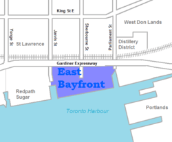
The area is bordered by the Parliament Street to the east, Jarvis Street and the Jarvis Slip to the west, and the rail line and Gardiner Expressway to the north.
The area is 15.5 hectares (38 acres) of land. The area was filled in during the 19th and 20th Century to accommodate growth of business needing access to the waterfront.
Changing land use
The area is undergoing a transformation and will host a number of different tenants:
Existing
- Toronto Tours Limited - one of a few local tour operators in the area
- Docking facilities for tour boats operating in the inner harbour in the east and west ends of the District
- The Guvernment, a former nightclub
A number of small industrial-commercial business parks dots the area, but some are being demolished and replaced with parking lots. There are four privately owned public parking lots in the district.
New
.jpg)

- Water's Edge Promenade - a tree lined boardwalk from Jarvis to Sherbourne
- Dockside at Corus Quay
- home to Corus Entertainment at Corus Quay
- Sugar Beach
- Sherbourne Common - a 1.5 hectares (3.7 acres) park being designed by Phillips, Farevaag, Smallenburg
- future home of George Brown College Waterfront campus opening in 2012
- Parkside - Great Gulf Group 36 floor condo project designed by Moshe Safdie
- Bayside - city owned land for future residential, cultural and retail development
- Quayside - future commercial and residential development
- Parliament Wavedeck - mixed use public space/water treatment facility
The district is mostly concrete with very few trees or greenspace. The Water's Edge Promenade will provide tree line board walk to the area. Sugar Beach and the future Sherbourne Common will provide some green space. The area's revitalization is being managed by Waterfront Toronto, a partnership of Federal, Provincial and local governments encouraging progressive and sustainable development of the Toronto waterfront.
The area includes a 130,000-square-metre (1,400,000 sq ft) office and institutional zone on the dockside tract of East Bayfront. This section consists of the 42,000-square-metre (450,000 sq ft) Corus Quay and the George Brown College's Health Sciences Campus.
In December 2009, Waterfront Toronto revealed the first major private sector development for the district, called Parkside. The $200 million residential development project, designed by Moshe Safdie and developed by Great Gulf Group of Companies, will be located on the northeast corner of Queen's Quay East and Sherbourne, south of the Gardiner Expressway and just east of the new Sherbourne Park.
List of Quays and Slips
Most of the remaining slips are not in use due departure of a number of business along the water's edge:
- Jarvis Street Slip
- Parliament Street Slip
- Pier 27
Transportation
The Bayfront area is accessed by various roads and expressways:
- Queen's Quay (Toronto) East - provides access through the centre of the precinct
- Lake Shore Boulevard East - provides access along the northern end of the district
- Gardiner Expressway - forms northern boundary along with Lake Shore Boulevard East with on/off ramps at Jarvis and Sherbourne
- Lower Jarvis Street - forms western boundary; one of the few north-south routes connecting the area to the neighbourhoods north of the Gardiner
- Parliament Street - one of the few north-south routes connecting the area to the neighbourhoods north of the Gardiner
- Lower Sherbourne Street - one of the few north-south routes connecting the area to the neighbourhoods north of the Gardiner
There are a number of local routes in the area cut off by either Lake Ontario or the Gardiner:
- Freeland Street - named for Rand Freeland, owner of Fantasy Farm
- Cooper Street - likely for mill operator William Cooper (businessman)
- Richardson Street - named for Hugh Richardson (shipowner), Toronto's first harbour master
- Shaw Street - named for former Mayor John Shaw (Canadian politician)
- Bonnycastle Street - named for Richard H. G. Bonnycastle, founder of Harlequin Enterprises (now owned by nearby Toronto Star)
Most of these local routes exists to service local businesses and customers.
Future plans by the TTC would see streetcar service in the district.[1] Streetcars would run from Union Station down to Bay and Queen's Quay, head east along the Queens Quay (southside) to Parliament Street. The interim terminus at Parliament will feature a loop, but the TTC plans to extend the route into the East Donlands in the future.
The Toronto Transit Commission has two bus routes in the precinct's west end:
- 6 and 6A Bay - running along Queen's Quay East, Freeland Street and Lower Jarvis
- 75 Sherbourne - running along Lower Sherbourne, Lower Jarvis and Queen's Quay East
There is no public transit in the east end of the precinct. There are plans to develop a light rail line along Queens Quay, initially as far as Parliament Street.[2][3]
See also
References
- ↑ http://www.waterfrontoronto.ca/explore_projects2/east_bayfront/queens_quay_blvd/east_bayfront_transit_environmental_assessment
- ↑ "Queens Quay Boulevard (East)". Waterfront Toronto. 2011-01-19.
The new Queens Quay will feature two lanes of east-west traffic on the north side of the street with a dedicated Light Rail Transit (LRT) line in the middle.
- ↑ Robert Mackenzie (2010-04-10). "QUEENS QUAY TRANSIT PROJECT: WILL HELP RENEW TORONTO'S WATERFRONT". Transit Toronto.
Transit is a key component — or quay component — of the plan. Two lanes of streetcar tracks will separate the pedestrian and cycling area from the roadway. Since these tracks will line the southern side of the traffic portion of Queens Quay, streetcars will cross fewer side streets and stop only at intersections, with signals prioritizing streetcars over other vehicles. And streetcars will also start to serve eastern harbour — the area between Bay and Parliament Streets.
External links
 |
St. Lawrence | West Don Lands Distillery District |
| |
| Harbourfront | |
Port Lands (Toronto Inner Harbour) | ||
| ||||
| | ||||
| Toronto Islands Toronto Harbour Lake Ontario |
Coordinates: 43°38′42″N 79°21′53″W / 43.64499°N 79.36459°W