East Bridgewater Common Historic District
|
East Bridgewater Common Historic District | |
 | |
  | |
| Location | East Bridgewater, Massachusetts |
|---|---|
| Coordinates | 42°1′47″N 70°57′9″W / 42.02972°N 70.95250°WCoordinates: 42°1′47″N 70°57′9″W / 42.02972°N 70.95250°W |
| Area | 69 acres (28 ha) |
| Built | 1703 |
| Architectural style | Georgian, Federal |
| NRHP Reference # | [1] |
| Added to NRHP | May 12, 1999 |
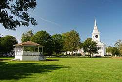
The East Bridgewater Common Historic District is a historic district encompassing the historic town center of East Bridgewater, Massachusetts. The district is centered on the town common, which was established in 1721, and radiates along Central Street away from the common. The oldest houses in the district date to 1703, and the Old Graveyard is also known to have been in use by that time. The First Parish Church, a focal point of the common area, was built in 1794 and extensively restyled in the 1850s. Town offices are now housed in the estate house of the Aaron Hobart, built in the 1850s in the Italianate style.[2]
The district was listed on the National Register of Historic Places in 1999.[1]
See also
References
- 1 2 National Park Service (2008-04-15). "National Register Information System". National Register of Historic Places. National Park Service.
- ↑ "NRHP nomination for East Bridgewater Common Historic District". Commonwealth of Massachusetts. Retrieved 2014-05-21.
| Topics |  | ||||||||||||||||||||||||||||||
|---|---|---|---|---|---|---|---|---|---|---|---|---|---|---|---|---|---|---|---|---|---|---|---|---|---|---|---|---|---|---|---|
| Lists by county | |||||||||||||||||||||||||||||||
| Lists by city |
| ||||||||||||||||||||||||||||||
| Other lists | |||||||||||||||||||||||||||||||
| |||||||||||||||||||||||||||||||
This article is issued from Wikipedia - version of the 11/27/2016. The text is available under the Creative Commons Attribution/Share Alike but additional terms may apply for the media files.