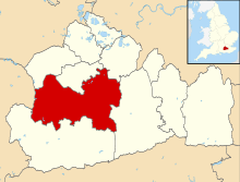
East Horsley
| East Horsley | |
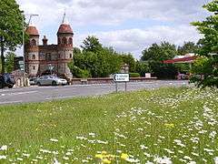 The prominent former gatehouse to Horsley Towers on Guildford Road has mock-medieval turrets. Flower meadows rest on the lower slopes of the North Downs here. |
|
 Inlaid brickwork settings depicting two coats of arms and a crown in rubble masonry wall of the noble Lovelace family who long lived in the village |
|
 East Horsley |
|
| Area | 7.4 km2 (2.9 sq mi) |
|---|---|
| Population | 4,290 (Civil Parish 2011)[1] |
| – density | 580/km2 (1,500/sq mi) |
| OS grid reference | TQ0952 |
| Civil parish | East Horsley |
| District | Guildford |
| Shire county | Surrey |
| Region | South East |
| Country | England |
| Sovereign state | United Kingdom |
| Post town | Leatherhead |
| Postcode district | KT24 |
| Dialling code | 01483 |
| Police | Surrey |
| Fire | Surrey |
| Ambulance | South East Coast |
| EU Parliament | South East England |
| UK Parliament | Mole Valley |
Coordinates: 51°15′40″N 0°25′59″W / 51.261°N 0.433°W
East Horsley is a village and civil parish in Surrey, England. The settlement is 21 miles South West of London, partly on the A246 between Leatherhead and Guildford. Most development is concentrated around the junction of two long roads directly north of this road. Horsley and Effingham Junction railway stations are on the New Guildford Line in the parish (connected to London Waterloo). The village has the parade of shops and businesses of the two Horsleys (see West Horsley), Otherwise the two-halves of ancient Horsley are similar in having substantial woodland and some chalky lower slopes, in the south, of the North Downs.
East Horsley had 1,343 detached homes and fewer than 157 of any single category of the three main categories nationally that describe dwelling types, at the 2011 census. At that census the highest proportion of those of working age fell into the second most senior category used by the Office for National Statistics, followed by those in the highest category.
History
- Manors
East Horsley appears in Domesday Book of 1086 as having two manors, listed under the chief manor's heading of Horslei. This was held by Lanfranc, Archbishop of Canterbury. Its domesday assets were: 3 hides and 1½ virgates; 8½ ploughs, woodland worth 50 hogs. It rendered £5 per year to its overlords.[2]
The Bishop's Manor in East Horsley seems to have belonged to the see of Exeter throughout the Middle Ages. Malden writing in 1911 associates closely the Domesday entry in Latin meaning 'Bishop Osborn of Exeter holds Woking' with this manor which his successors later held, since there is no trace of any land held by the Bishop of Exeter in Woking in Pipe rolls, Assize Rolls, feet of fines or the records of Lambeth Palace.[3]
- Enclosure and development
In 1792 an Inclosure Act enabled William Currie MP to inclose most of Horsley Common at the northern end of the parish and the common fields and waste at the southern part, very much on the chalk. The parsonage and glebe were at the same time moved within the parish.[3]
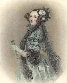
The village is the site of Horsley Park, a gothic mansion designed by Sir Charles Barry (later the architect of the Houses of Parliament) for Currie in place of an earlier building. William Currie, a distiller and banker, had bought the property in 1784 and over the next 44 years made extensive changes to the village including rebuilding most of the houses in the village, establishing the school and restoring the church.[3] After William Currie's death in 1829 the property was acquired by the 1st Earl of Lovelace. It was the marital home of Ada, Lady Lovelace (the poet Lord Byron's daughter) and later Sir Thomas Sopwith, aviation pioneer. In 1971 it was used as a (Defence) Staff Training College and was placed in the second category of the English Heritage scheme of architecture as a Grade II* listed building.[4] The buildings were used as a location for the film, The Colour of Magic, in 2008. It is currently in use as a hotel.
The 3rd Earl of Lovelace imposed restrictive covenants on most of his former fields when selling these to private developers in the early 20th century leading to the overwhelming proportion of homes being detached; no minimum plot size is specified by these and planning is controlled by Guildford Borough Council, subject to advice from the civil parish council.
Geography
The settlement is 21 miles south east of London, partly on the A246 between Leatherhead and Guildford. As such it forms a cross between a nucleated village and dispersed settlement directly north of this road, with a wide array of medium-sized individual home plots typically of 0.4 acres (0.16 ha). Horsley and Effingham Junction railway stations are on the New Guildford Line in the parish (connected to London Waterloo and both have a line direct to Leatherhead, Epsom and Sutton). The village has the parade of shops and businesses of the two Horsleys (see West Horsley), Otherwise the two-halves of ancient Horsley are similar in having substantial woodland and some chalky lower slopes, in the south, of the North Downs.[5]
In the light of the local emphasis on detached homes, journalist Caroline McGhie considered East Horsley to show signs of becoming 'Britain's richest village' based upon 46 house sales of over one million pounds in the 12 months to March 2011. The study explicitly excludes, however, groups of considerably more expensive homes and areas of Oxfordshire, Buckinghamshire and Surrey with a higher level of average income.[6][n 1]
Amenities
- Shops and businesses
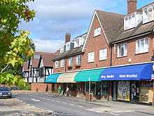
The main row of shops is near the western railway station on a local thoroughfare from the end of Forest Road towards Ockham, a small number of professions operate here, such as accountants, opticians and the NHS medical practice. A Legacy hotel is in the village.[7]
- Religious centres
The medieval church continues as part of a larger charitable organisation in the Diocese of Guildford and caters for Anglicanism, St Martin's.[8]
- Theatre
A village with a theatre (as does similarly-sized Godstone in the county), this is a well-equipped amateur production stage named the Nomad Theatre which is behind the smaller of East Horsley's two rows of shops, Bishopsmead Parade. Its construction was largely financed by National Lottery grants from Arts Council England. The theatre opened in October 1998 with a production of Dylan Thomas's Under Milk Wood.
Demography and housing
East Horsley had 1,343 detached homes (of which 1,309 were inhabited) and fewer than 183 of any other dwelling types at the 2011 census, and a high proportion of business-owners and directors, accordingly it was deemed Britain's "richest village" by The Daily Telegraph in 2011[9] and again in 2015.[10]
| Output area | Detached | Semi-detached | Terraced | Flats and apartments | Caravan/temporary/mobile home | Shared between households[1] |
|---|---|---|---|---|---|---|
| East Horsley (CP) | 1,309 | 151 | 50 | 183 | 4 | 0 |
The average level of accommodation in the region composed of detached houses was 28%, the average that was apartments was 22.6%.
| Output area | Population | Households | % Owned outright | % Owned with a loan | hectares[1] |
|---|---|---|---|---|---|
| East Horsley (CP) | 4,290 | 1,697 | 51.8 | 35.4 | 740[1] |
The proportion of households in East Horsley who owned their home outright was 19.3% above the regional average. The proportion who owned their home with a loan was 0.3% greater than the regional average; providing overall a lower proportion than average of rented residential property relative to the average in Surrey, the district and the country.
| Output area | Higher Managerial, Administrative and Professional Occupations | Lower Managerial, Administrative and Professional Occupations | Intermediate Occupations | Small Employers and Own Account Workers | Lower Supervisory and Technical Occupations | Semi-Routine Occupations | Routine Occupations | Never worked or long-term unemployed | Full-time students[1] |
|---|---|---|---|---|---|---|---|---|---|
| East Horsley (CP) | 737 | 893 | 376 | 310 | 93 | 149 | 80 | 51 | 205[1] |
Politics
Local government is administered by Guildford Borough Council and Surrey County Council.
At Surrey County Council, one of the 81 representatives represents the area within the Horsleys division.[11]
At Guildford Borough Council the ward of the borough is deemed appropriate to be best represented under the current constitution by three councillors.[12]
| Election[13] | Member[12] |
Ward | |
|---|---|---|---|
| May 2015 | Matthew Sarti | Clandon and Horsley (formerly: Lovelace) | |
| May 2015 | Jenny Wicks | Clandon and Horsley (formerly: Lovelace) | |
| May 2015 | David Reeve | Clandon and Horsley (formerly: Lovelace) | |
| Election | Member[14] |
Electoral Division | |
|---|---|---|---|
| 2013 | W.D. 'Bill' Barker | Horsleys | |
East Horsley is in Mole Valley. At the elections since its inception a Conservative has won it.
Neighbouring areas
Neighbouring areas are:
 |
across part of West Horsley Ockham |
Ockham | Downside | |
| West Horsley | |
Effingham | ||
| ||||
| | ||||
| across the North Downs Shere |
across the North Downs Gomshall, Shere (large hamlet) |
Effingham Upper Common or Dogkennel Green including woods Effingham |
See also
Notes and references
- Notes
- ↑ Examples include Richings Park, Gerrard's Cross, Wentworth and/or its village of Virginia Water (with 146 sales over £1M in the same period), Saint George's Hill and Burwood Park. In East Horsley income groups are not especially high for a South East England village; at the 2011 census the ONS found the largest single group of those aged 16–74 were those of the second category out of eight: lower managerial, administrative and professional occupations.
- References
- 1 2 3 4 5 6 Key StatisticsL Key figures, Dwellings, Tenure; Quick Statistics: Population Density United Kingdom Census 2011 Office for National Statistics Retrieved 21 November 2013
- ↑ Surrey Domesday Book Archived 30 October 2007 at the Wayback Machine.
- 1 2 3 H.E. Malden (editor) (1911). "Parishes: East Horsley". A History of the County of Surrey: Volume 3. Institute of Historical Research. Retrieved 22 November 2013.
- ↑ Historic England. "Details from listed building database (1294810)". National Heritage List for England.
- ↑ Grid square map Ordnance survey website
- ↑ Britain's Richest Villages
- ↑ Legacy Hotels in England Retrieved 22 November 2013
- ↑ East Horsley – St Martin The Church of England. Retrieved 22 November 2013
- ↑ http://www.telegraph.co.uk/finance/property/luxury-homes/8410974/Britains-richest-villages.html
- ↑ http://www.telegraph.co.uk/finance/property/house-prices/11453685/Welcome-to-the-villages-with-the-most-1m-plus-homes.html
- ↑ Electoral Divisions Surrey County Council. Retrieved 6 November 2013
- 1 2 Your local councillors Guildford Borough Council. Retrieved 20 November 2013
- ↑ Returning Officer's Declaration of Result for the May 2015 Local Council Elections. Retrieved 27 October 2015
- ↑ Your Councillor Surrey County Council. Retrieved 22 November 2013
External links
| Wikimedia Commons has media related to East Horsley. |
- St Martin's Church
- East Horsley Bowling Club
- Horsley Evangelical Church
- The Nomad Theatre
- Portrait of William Currie (1756–1829)
- Horsley Football Club
- Horsley Decorative and Fine Arts Society