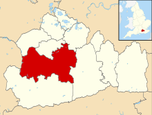
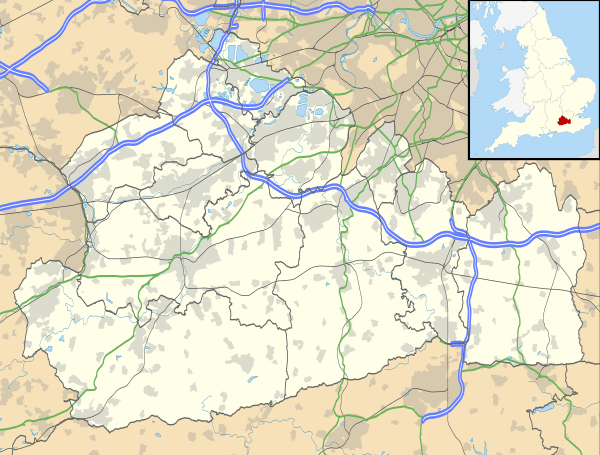
Send, Surrey
| Send | |
 The Recreation Ground |
|
 Send Manor, Send Marsh |
|
 Send |
|
| Area | 6.95 km2 (2.68 sq mi) |
|---|---|
| Population | 4,245 (Civil Parish 2011)[1] |
| – density | 611/km2 (1,580/sq mi) |
| OS grid reference | TQ028553 |
| – London | 23.3 |
| Civil parish | Send |
| District | Guildford |
| Shire county | Surrey |
| Region | South East |
| Country | England |
| Sovereign state | United Kingdom |
| Post town | WOKING |
| Postcode district | GU23 |
| Dialling code | 01483 |
| Police | Surrey |
| Fire | Surrey |
| Ambulance | South East Coast |
| EU Parliament | South East England |
| UK Parliament | Mole Valley |
Coordinates: 51°17′16″N 0°31′35″W / 51.2878°N 0.5263°W
Send is a village and civil parish in the Guildford borough of the English county of Surrey. Send acquired its name during the Great English Vowel Shift from the word sand, which was extracted at various periods until the 1990s for construction and other purposes at pits in the outskirts of the parish. The north of Send is at the southern-eastern edge of the Bagshot Formation.
Send is buffered by Metropolitan Green Belt from other villages and towns except for the Grove Heath neighbourhood of Ripley. A rural band of the village adjoins the River Wey including Cartbridge and Send Marsh – this land has been drained and the river tamed by sluices, the Broadmead Cut and the Wey Navigation, adjoining. The vast majority of the built-up areas are not within an area of flood risk. Between the Wey and its canal in the far north of the parish are the Papercourt and Broad Mead SSSIs.
History
Send appears in Domesday Book of 1086 as Sande. It was held by Rainald (Reginald) from Alvred de Merleburgh (Marlborough). Its domesday assets were: 20 hides; 1 church, 10 ploughs, 2 mills worth £1 3s 6d, 5 fisheries worth 4s 6d, 84 acres (34 ha) of meadow, woodland worth 160 hogs. It was headed by 41 households and had additionally fifteen serfs, although whether they had households or not is uncertain. It rendered £15 10s 0d per year to its overlords.[2] In this case the manorial lords were simply recorded as Herbert; Reginald son of Erchenbald; and Walter, seemingly Anglo-Saxon and the Book states it was held at the time of the Norman Conquest by Karli of Norton.[3]
The parish saw a little-known skirmish. On 14 June 1497 the first Cornish Rebellion was launched against Henry VII, the rebels were marching from Cornwall, to Kent unbeknown to the King, and having already passed Guildford, had a skirmish with some of the outposted royal troops on the road from Guildford to London. The troops fell back or were outmanoeuvred, for they had lost the rebels on the 16th and were looking for them on the Portsmouth Road again near Kingston when they were actually on the border of Kent. Old maps mark the place where the road crosses the stream which joins the Wey near Send as St. Thomas's Waterings.[4]
Ripley was at the time of the Domesday Book a hamlet of Send. In 1878 Ripley gained its own parish. The earliest official record such as a Patent Roll, revealing its manor's existence is in 1279. Growth in ambition of the local nobility coupled with a large enough population led to the first place of worship being built at Ripley, to become a chapelry (village with a chapel so financially dependent on another village), also to St Mary the Virgin, in approximately the year 1160.[4]
Brickfields were developed in the south of Send by the 1870s, running until at least 1911.[4]
The Leese Baronets "of Sendholme in Send in the County of Surrey", who lived at the large house of that name in Send was a title created in 1908 for Joseph Leese, Liberal Member of Parliament for Accrington from 1892 to 1910. The third Baronet was a Lieutenant-General in the Coldstream Guards and served as Commander-in-Chief of the Allied Land Forces in South-East Asia from 1944 to 1945 and as General Officer Commanding-in-Chief of the Eastern Command from 1945 to 1946. This was in the middle of a period when at least seven other wealthy entrepreneurs, aristocrats, and publicly funded celebrities built their homes in Send, see notable residents.
Send had the base of defunct 1950s Formula One and sports car constructor Connaught Engineering, generally branded as Connaught.
Geography and transport
Send is a lightly dispersed village centred 23 miles (37 km) south-west from Charing Cross and 6 miles (10 km) south-west of junction 10 of the M25[5] and has a developed clustered centre which was until the mid-20th century on the old course of the old Portsmouth Road which bisects the highest settled part of the village, Burntcommon which is on the start of rise of the London Clay, in turn, reaching almost as far as the North Downs through Clandon.[4] Relieved by the construction of a six-lane by pass (which forms the very long south-east border), the A3 trunk road, this makes the parish approximately triangular. The parish is bounded to the west and part of its northern side by the River Wey, which is controlled by sluices and has been expanded in capacity by a navigable channel running alongside, the Wey Navigation.
For most of the village the nearest railway station is at West Clandon on a longer line between Guildford and London. Woking on the South West Main Line is closer to a part of the village and offers semi-fast and fast services as opposed to only stopping services.
 |
across Metropolitan Green Belt Westfield, Woking, Surrey |
Old Woking Pyrford |
Ripley | |
| across Metropolitan Green Belt Sutton Green |
|
Ripley | ||
| ||||
| | ||||
| across Metropolitan Green Belt including Sutton Park Burpham |
West Clandon | East Clandon |
Soil
Send is on a gently rising patch of Bagshot Sand, with Cartbridge like Ripley, on sand and gravel of the lower Wey Valley; a southern part of the parish is on generally higher still London Clay.[4]
Elevation
Elevations range from 49m Above Ordnance Datum in the south[6] to 22m at the far northern border on the Wey Navigation.[7]
Localities
Cartbridge
Cartbridge is a mostly amorphous locality that covers the western end of the village's main street, particularly where it turns to the north towards Woking.
Send Marsh
Based drawing of arbitrary boundaries by Surrey County Council its population at the United Kingdom Census 2001 was almost half of the village as a whole, at 1,937.[8]
The neighbourhood is, insofar as it is used, contiguous with the clustered, built-up estates of Boughton Court Avenue and the Portsmouth Road forming Burntcommon. For census analyses of largest neighbourhoods in Surrey the county council in 2001 opted to consider Burntcommon as a non-notable locality jointly with Send Marsh, under the term Send Marsh.
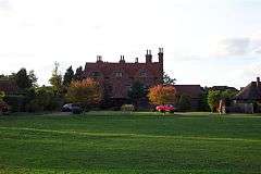
Send Marsh has Send's Grade II listed late 17th century manor house on the village green, with rear extensions of the 19th century. It is built of almost brown brick in English bond.[9] It has one public house called the Saddlers Arms and no shops or church. Unusually for Guildford schools it is within the admission priority area of Guildford's George Abbot School most years and the boundaries have not to date excluded it to be replaced by for instance closer areas of north-western Guildford.
Burntcommon
Burntcommon is a locality of Send that directs adjoins the Send Marsh (eastern) part of the village. Its nearest town is Woking, which lies approximately 3.1 miles (5.0 km) north-west.[10]
Amenities
Health and well-being
The small Send Surgery on Send Road next to the Church Rooms closed in 2003 and reopened on Send Barns Lane as the modern Villages Medical Centre serving 7,000 people in Send, Ripley and the surrounding villages.[11]
Sunshine Clinic, a business, occupies the former Send Surgery site and sells complementary (supportive) and natural health therapies and beauty treatments.[12]
Businesses
The main route through the community runs NE/SW, the A247 Send Road, along which are scattered the shops, businesses and facilities.
These include the post office, a takeaway, diving shop/centre,[13] a fireplace outlet,[14] an independent funerals firm, a hairdressers, a microscope and measuring devices manufacturer[15]
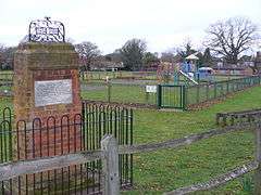
Send has a recreation ground, the Lancaster Hall and the Church Rooms.
Send has two pubs: The New Inn in Cartbridge, adjacent to the Wey Navigation and The Saddlers Arms in Send Marsh.
The Old Hall on Send Marsh Road provides full residential care with 40 rooms.[16]
Schools
Historic
Send (National) School was built in 1834 and enlarged in 1892. When the school closed the building, off Send Hill, was converted to residential use and is known as The Old School.
Current
Send Church of England (Foundation) First School was built in 1958.
St Bede's Church of England (Aided) Junior School was built in 1939. During the planning process questions were raised in the House of Commons about the provision of adequate drainage – HC Deb 23 November 1938 vol 341 cc1763-4W.[17]
The schools formed the Federation of Send Church of England Schools on 29 March 2012.
Religion
Church of England

Send parish church[18] is dedicated to St Mary the Virgin and dates from around 1220.[19] The nave was rebuilt and the tower added in around 1485. New kitchen and toilet facilities were completed in 2002. A York stone path was laid in the churchyard in 2003. The church is a grade-2* listed building and is the oldest building still in use in Send. In January 2008 the church was voted Visitor/Leisure Attraction of the Year in the Guildford Life with Style[20] awards attracting 75% of the votes and beating the Royal Horticultural Society gardens at Wisley, Watts Gallery, Guildford Tour Guides and Surrey Hills Llamas. In October 2008 the church received the Mayor of Guildford's Award for Access.
Roman Catholicism
St William of York (RC) closed in 2007, the village in that church's system is in the parish of Ripley.
Evangelical
Send Evangelical Church[21] opened in May 1974 using a former Congregational chapel in the Cartbridge (west side) of the village, built in 1875.
Islam
Two mosques are in the closest town, Woking, including the oldest used in the country, the Shah Jahan Mosque.
War memorials
Send has three such memorials.[22]
A Celtic-style stone cross next to the Church Rooms on Send Road rises above these inscriptions: '1914–1918 In memory of the men of this village who at the call of duty gave their lives their country. Faithful unto death.' The names of the fallen are: (1914–1918) G. Frederick Barnes, William Barnett, Arthur Brackley, William C. Collins, George F. Craddock, Trevor Durrant, Robert G. Fuller, Albert Giles, William Giles, Alan F. M. Grant, David Millard, Archibald Muir, Maurice Simmonds, W. Kenneth Sinclair, Robin R. Skene, Ernest Tickner, Jack Tickner, Herbert W. Walls, Ernest A. Whapshot, Sidney Wright, Alfred Wye. (1939–1945) Robert P. Dixon, Bradford W. O. Dockerty, Robin Giles, Rupert P. James, Frank Hack, Hubert E. Murrell, Ian Matheson, Brian T. Opperman, Donald W. S. Price, William Smith, Edward P. Winton, Edward Wood, Leslie Woolley, William Pratt.
A brick memorial mounted with a wrought iron '1914 1918' in the recreation ground near the corner of Send Road and Sandy Lane bears the words: 'This recreation ground was purchased by public subscription and was opened on 1 June 1920 for the benefits of the inhabitants of Send as a memorial to the sailors and soldiers who fell and in grateful recognition of those in the village who took part in the Great War of 1914–1918. Trustees: S. S. Boorman, A. H. Lancaster, J. A. Shirer, W. M. Grant, F. W. Morgan Jones, W. G. Whitbourn.'
A stone tablet on the north wall of the nave inside the parish church bears this inscription: 'The peal of six bells was hung as a memorial to those of this parish who lost their lives in two world wars and as a thank offering for victory.' The names listed are the same as on the Celtic-cross memorial but with the addition of five people 'killed by enemy action': V. Bowers, H. C. Parsons, H. E. Privett, M. J. Privett and V. Privett. Members of the Privett family were killed on 21 August 1944 by the explosion of a V1 flying bomb which landed on their home at Burnt Common Cottages.[23]
Demography and housing
The United Kingdom Census 2011 reported Send's population to be 4,245, an increase of 107 since the 2001 census. The number of households was 1,665, an increase of 42 since the 2001 census.
| Output area | Detached | Semi-detached | Terraced | Flats and apartments | Caravans/temporary/mobile homes | shared between households[1] |
|---|---|---|---|---|---|---|
| (Civil Parish) | 908 | 551 | 90 | 116 | 0 | 0 |
The average level of accommodation in the region composed of detached houses was 28%, the average that was apartments was 22.6%.
| Output area | Households: % Owned outright | % Owned with a loan | hectares[1] |
|---|---|---|---|
| (Civil Parish) | 41.3% | 41.4% | 695[1] |
The proportion of households in the civil parish who owned their home outright compares to the regional average of 35.1%. The proportion who owned their home with a loan compares to the regional average of 32.5%. The remaining % is made up of rented dwellings (plus a negligible % of households living rent-free).
Occupations
The high street provides some professional occupations and technical businesses, the schools and nearby prison form most of the government merit services; other occupations existing in the parish include manufacturing, agriculture and food and leisure-related categories of employment. Nonetheless, the village demographically has a very high proportion of professionals and in relation to these, it is part of the London Commuter Belt, with the City of London being the main destination by train from Woking. The nearest entertainment and large retail premises are in Woking. A former landfill in Send is a 20 hectare plantation of short rotation coppice willow.[24] Occupations of the 2,114 workers between the ages of 16 and 74 were broken down in the 2011 census as follows:
| Category of employment | Number[1] |
|---|---|
| Managers, Directors and Senior Officials | 390 |
| Professional Occupations | 485 |
| Associate Professional and Technical Occupations | 310 |
| Administrative and Secretarial Occupations | 265 |
| Skilled Trades Occupations | 215 |
| Caring, Leisure and Other Service Occupations | 151 |
| Sales and Customer Service Occupations | 110 |
| Process, Plant and Machine Operatives | 69 |
| Elementary Occupations | 119 |
Population over time
Data for 1801–1961 is available at Britain Through Time.[25] The loss of Ripley in 1878 ecclesiastically and in 1933[26] as a secular administrative unit (civil parish) represented almost half of the land area of the village.[27]
| Year | 1801 | 1811 | 1821 | 1831 | 1841 | 1851 | 1881 | 1891 | 1901 |
|---|---|---|---|---|---|---|---|---|---|
| Population | 1,024 | 1,090 | 1,283 | 1,483 | 1,538 | 1,555 | 1,855 | 2,049 | 2,301 |
| Year | 1911 | 1921 | 1931 | 1941 | 1951 | 1961 | |||
| Population | 2,544 | 2,847 | 3,278 | n/a | 2,788 | 3,680 | |||
Arts
Novelists
The children's novelist Monica Edwards lived at Send from 1939 to 1947.
Film location
In 1969, a scene for The Tellingbone episode of Catweazle featuring Geoffrey Bayldon filmed two backgrounds in Send: Church Lane using the lych gate and Send Parish Church and 1 Heath Farm Cottages, Tannery Lane as "Sam's Cottage". "Sam Woodyard" was played by Neil McCarthy. In 1999, scenes for The Mrs Bradley Mysteries starring Dame Diana Rigg and Neil Dudgeon were filmed in the churchyard. In April 2009, scenes for a BBC Drama production of Jane Austen's "Emma", adapted by Sandy Welch and starring Romola Garai, Michael Gambon, Jonny Lee Miller, Blake Ritson, Johdi May, Christina Cole, Robert Bathurst, Louise Dylan, Dan Fredenburgh, Tamsin Greig and Rupert Evans were filmed in and around Send Parish Church. In August 2012 Willow Drive was used to film scenes for Cuban Fury, starring Nick Frost.[28]
Prison
Counterintuitively now named after the village is HMP Send, a women's prison on the site of a former isolation hospital. Following parish area reduction in the south[4] the jail is now in the southern part of the parish of Ripley surrounded by farmland and woodland.
Sport
Send's local football team is called Send United. Sailing is organised and carried out on Papercourt Lake which is owned by Papercourt Sailing Club.[29] There is fishing on the River Wey and in the nearby sandpits.
The Concorde Cricket Club (formerly British Aerospace Cricket Club) are based at Sendholme on Potters Lane.[30] Sendholme was the home of William Hargreaves Leese who went on to play for the Marylebone Cricket Club in the later part of the nineteenth century.[31]
Admirals, generals and airmen

Lieutenant-General William Evelyn Colonel of the 29th Foot in the British Army and Member of Parliament for Helston (1767–74),[32] a son of Sir John Evelyn of Wotton, established his home at Send Grove, Church Lane, and he laid out the grounds.
On his death, in 1783, it was bought by Admiral Sir Francis William Drake, Governor of Newfoundland (1750–1752), second in command to Rodney in his victory of 1782 over De Grasse. As Rear-Admiral, Francis William Drake flew his flag on HMS Victory from 26 September 1780 to 29 December 1780.[33]
Flight Lieutenant Robin R Skene, one of the first members of the Royal Flying Corps, was buried in the churchyard after crashing in his Blériot monoplane shortly after take-off from Netheravon, Wiltshire, in 1914 on 12 August en route to Dover and France at the start of the First World War. He and mechanic R. Barlow were the first members of the Royal Flying Corps to die on active duty and among the first British casualties of the war.
Flooding

Following flooding in the east of Send Marsh in 2000, when 16 properties were flooded to a depth of 1m, causing £600,000 of damage, a five-month Environment Agency (EA) scheme costing £400,000 began in February 2007 to reduce the risk from the East Clandon stream. The stream was diverted in the 1870s for brick-making and could revert to its original course when flooded.[34] Demonstrated by the relatively few properties affected, almost all built-up areas in the parish are not subject to flood risk according to EA data.[35]
Notable residents

- The British guitarist Eric Clapton spent two years as a pupil at Send's one-time secondary modern school (now St. Bede's Church of England Junior School).
- Musician Paul Weller lived for several years in Vicarage Lane.
- Anthony Phillips, former Genesis guitarist, lived and recorded at Send Barns on Send Barns Lane until 1981.[36]
- The Send Barns Orchestra and Barge Rabble conducted by Jeremy Gilbert are credited on the 1977 album The Geese and the Ghost.
- Ghost Production Studios,[37] based at the Old Riding Stables on Send Hill, have worked with several well-known clients, including Paul Connelly, Ben Lovejoy, Sue Macmillan, Social, Satellite State, Go West, Tony Hadley, Heat Wave, Charlie Morgan, Mark Brizickey, Adam Wakeman, Victoria Beckham, Elton John, and Draven.
- Elizabeth Macarthur Onslow (1840–1911), an Australian pastoralist and property manager[38] born in Menangle, New South Wales, died during a visit to England and is buried in Send churchyard.
- In 1911 Send Grove was the property of and occupied by the Misses Onslow.
- Woodhill was the principal home ('seat') of the Dowager Countess of Wharncliffe.[4]
- Sir Herbert Holt (1856–1941), divided his time between Send Grove and his other home in Montreal's Golden Square Mile. His son, also called Herbert, inherited Send Grove after his death.
- Loelia Lindsay (1902–1993), best remembered as Loelia, Duchess of Westminster, lived at Send Grove and later at the Old Vicarage in Church Lane.[39]
- Conservative MP Philip Hammond lives in Send Barns.
References
- 1 2 3 4 5 Key Statistics; Quick Statistics: Population Density United Kingdom Census 2011 Office for National Statistics Retrieved 21 November 2013
- ↑ Surrey Domesday Book Archived 30 October 2007 at the Wayback Machine.
- ↑ Domesday Map Retrieved 24 October 2013
- 1 2 3 4 5 6 7 "Parishes – Send with Ripley | British History Online". British-history.ac.uk. 22 June 2003. Retrieved 7 August 2009.
- ↑ Grid Reference Finder distance tools
- ↑ Grid square map Ordnance survey website
- ↑ Grid square map Ordnance survey website
- ↑ Surrey County Council census data Archived 25 October 2007 at the Wayback Machine.
- ↑ Historic England. "Details from listed building database (1029348)". National Heritage List for England.
- ↑ Burntcommon. Nestoria.co.uk. Accessed 5 June 2012.
- ↑ Send Village Medical Centre
- ↑ http://www.bodyandsoulclinic.co.uk/
- ↑ "New Dawn Dive Centre, Send, Woking, PADI Diver Training, Dive Trips and Diving Holidays". Newdawndive.co.uk. 8 November 2007. Retrieved 7 August 2009.
- ↑ Adam Wakeford Fireplaces. "Wakeford Fireplace Shop in Guildford & Woking. Firpalce Range Antique, Brick, Cast Iron, Marble, Slate & Stone". Wakefordfireplaces.com. Retrieved 7 August 2009.
- ↑ "Leading stereo microscope and measuring device manufacturer – Vision Engineering". Visioneng.com. Retrieved 7 August 2009.
- ↑ "Surrey Nursing Homes". Theoldgroup.co.uk. Retrieved 7 August 2009.
- ↑ "SEND (SURREY). (Hansard, 23 November 1938)". www.hansard.millbanksystems.com. Retrieved 20 July 2016.
- ↑ "St Mary's church, Send, Woking, Surrey UK". Sendparishchurch.co.uk. Retrieved 7 August 2009.
- ↑ Picture of the Church St Mary the Virgin
- ↑ "Archived copy". Archived from the original on 27 September 2009. Retrieved 2009-08-08.
- ↑ http://www.sendec.org/
- ↑ "Send Surrey War Memorials". www.windowonwoking.org.uk. Retrieved 20 July 2016.
- ↑ "Archived copy" (PDF). Archived from the original (PDF) on 22 August 2006. Retrieved 2009-08-08.
- ↑ "Archived copy" (PDF). Archived from the original (PDF) on 8 October 2011. Retrieved 2009-08-10.
- ↑ "Braunton through time : Population Statistics : Total Population". A Vision of Britain through Time. Retrieved 13 July 2013.
- ↑ Relationships and Changes A Vision of Britain, the University of Portsmouth and others. Retrieved 24 October 2013
- ↑ Boundary Map A Vision of Britain, the University of Portsmouth and others. Retrieved 24 October 2013
- ↑ "Nick Frost arrives in Send to film movie scenes". www.getsurrey.co.uk. Retrieved 20 July 2016.
- ↑ Papercourt Sailing Club
- ↑ "Concorde Cricket Club – Home Ground". Concordecc.co.uk. Retrieved 7 August 2009.
- ↑ "Surrey History : Exploring Surrey's Past – Archive Record". Exploringsurreyspast.org.uk. Retrieved 7 August 2009.
- ↑ L. "Worcestershire Regiment(29th/36th of Foot) Web site". Worcestershire Regiment. Retrieved 7 August 2009.
- ↑ "Flag Officers 1778 – 1900". HMS-Victory. 17 November 1900. Retrieved 7 August 2009.
- ↑ "UK | England | Surrey | Work starts on flood prevention". BBC News. 20 February 2007. Retrieved 7 August 2009.
- ↑ Send – Flood Risk Areas Map Environment Agency
- ↑ "Biography". Anthonyphillips.co.uk. Retrieved 7 August 2009.
- ↑ "Archived copy". Archived from the original on 20 November 2008. Retrieved 2009-08-08.
- ↑ "Macarthur-Onslow, Eliza Elizabeth (1840 - 1911)". www.womenaustralia.info. Retrieved 20 July 2016.
- ↑ Lees-Milne, James (3 November 1993). "Obituary: Loelia Lindsay". The Independent. London. Retrieved 23 May 2010.
External links
| Wikimedia Commons has media related to Send, Surrey. |