East Lempster, New Hampshire
| East Lempster, New Hampshire | |
|---|---|
| Unincorporated community | |
|
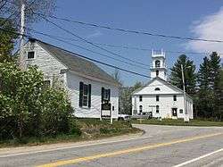
Miner Library and History Hall in East Lempster | |
 East Lempster  East Lempster | |
| Coordinates: 43°13′30″N 72°10′42″W / 43.22500°N 72.17833°WCoordinates: 43°13′30″N 72°10′42″W / 43.22500°N 72.17833°W | |
| Country | United States |
| State | New Hampshire |
| County | Sullivan |
| Town | Lempster |
| Elevation | 1,220 ft (370 m) |
| Time zone | Eastern (EST) (UTC-5) |
| • Summer (DST) | EDT (UTC-4) |
| ZIP code | 03605 |
| Area code(s) | 603 |
| GNIS feature ID | 866717[1] |
East Lempster is an unincorporated community in the town of Lempster in Sullivan County, New Hampshire, United States.
The village is located at the intersection of New Hampshire Route 10 with the Second New Hampshire Turnpike, a country road leading northwest to Lempster village, the town of Unity, and the city of Claremont. Route 10 connects East Lempster with Newport to the north and Marlow and Keene to the south. Mountain Road, a continuation of Second New Hampshire Turnpike, leads southeast over Lempster Mountain to the town of Washington.
References
Municipalities and communities of Sullivan County, New Hampshire, United States | ||
|---|---|---|
| City | 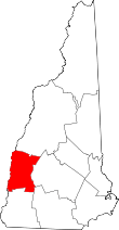 | |
| Towns | ||
| CDPs | ||
| Other villages | ||
This article is issued from Wikipedia - version of the 7/11/2016. The text is available under the Creative Commons Attribution/Share Alike but additional terms may apply for the media files.