East Stour, Kent
For details of the watermills powered by the river, see Stour watermills.
| River East Stour | |
|---|---|
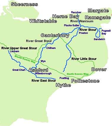 River Stour and Tributaries | |
| Basin | |
| Main source | Postling |
| River mouth |
Great Stour TR 01539 42793 Ashford 51°08′56″N 0°52′49″E / 51.14890°N 0.88020°ECoordinates: 51°08′56″N 0°52′49″E / 51.14890°N 0.88020°E |
| Physical characteristics | |
| Length | 10.3 mi (16.6 km) |
The River East Stour is one of the tributaries of the Great Stour in Kent. The East Stour, 10.3 miles (16.5 km) long [1]) rises on the Greensand ridge at Postling north of Hythe as a number of small streams. It then flows under the M20 motorway to continue in a westward direction: the river meanders across the Low Weald plain, passing Mersham on the way. The East Stour's confluence with the Great Stour is on both sides of Pledge’s Mill at the foot of East Hill, Ashford.
The South Willesborough Dykes are on the banks of the East Stour in Willesborough, Ashford and helps form part of the Ashford Green Corridor.

References
This article is issued from Wikipedia - version of the 11/6/2016. The text is available under the Creative Commons Attribution/Share Alike but additional terms may apply for the media files.