Eastern Region (Ghana)
| Eastern Region | ||
|---|---|---|
| region | ||
| ||
 Location of Eastern Region in Ghana | ||
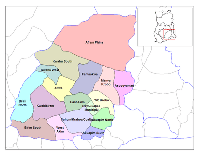 Districts of Eastern region | ||
| Country | Ghana | |
| Capital | Koforidua | |
| Districts | 26 | |
| Government | ||
| • Regional Minister | Ms Mavis Ama Frimpong | |
| Area | ||
| • Total | 19,323 km2 (7,461 sq mi) | |
| Area rank | Ranked 6th | |
| Population (2010 Census) | ||
| • Total | 2,633,154 | |
| • Rank | Ranked 3rd | |
| • Density | 140/km2 (350/sq mi) | |
| GDP (PPP) | ||
| • Year | 2013 | |
| • Per capita | $5,150 | |
| GDP (Nominal) | ||
| • Year | 2013 | |
| • Per capita | $2,500 | |
| Time zone | GMT | |
| Area code(s) | 034 | |
| ISO 3166 code | GH-EP | |
.gif)
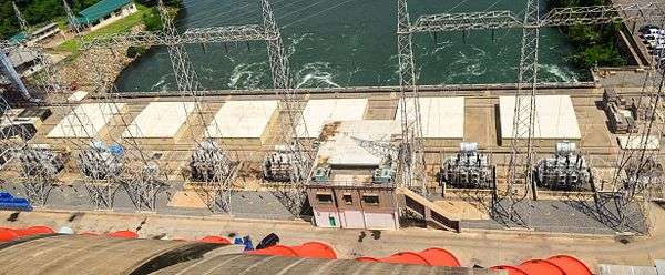
The Eastern Region is located in south Ghana and is one of ten administrative regions. Eastern region is bordered to the east by the Lake Volta, to the north by Brong-Ahafo region and Ashanti region, to the west by Ashanti region, to the south by Central region and Greater Accra region. Akans are the dominant inhabitants and natives of Eastern region and Akan and English are the main spoken languages. The Eastern region is the location of the Akosombo dam and the economy of the Eastern region is dominated by its high-capacity electricity generation. Eastern region covers an area of 19,323 square kilometres, which is about 8.1% of Ghana's total landform.[1]
Hydro project
High-capacity electricity generation Akosombo Hydroelectric Project contains three main tributaries: the Black Volta; the White Volta and the Red Volta and the Akosombo Hydroelectric Project flows into the Gulf of Guinea on the Atlantic Ocean.[2]
Education
Secondary(High) Schools
- Krobo Girls' Presbyterian Senior High School
- St. Peter's Boys Senior High School
- Aburi Girls Senior High School
- St Roses Senior High (Akwatia)
- Pope John Senior High School and Minor Seminary
- Koforidua Secondary Technical School
- New Juaben Senior High Commercial School
- Akwamuman Senior High School
- Okuapeman Senior High School
- St Matins Senior High School
- Benkum Senior High School
- Ghana senior high school koforidua
- Asamankese senior high School
- Akim oda Senior high School
- Akim Swedru Senior high School
- Saint francis Senior High School
- Mpraeso Senior High School
- Oti Boateng Senior High School
- Oyoko Methodist Senior High School
- Suhum presby senior High School
- Ofori Panin Senior High School
- Suhum Senior High and technical School
Districts
District changes
The Afram Plains District does not exist any longer. The Akuapim South District, East Akim District and Kwahu West Districts have been upgraded to Municipal status with the addition of Birim Central Municipal District which is entirely new. Other new districts include Akyemansa District, Kwahu East District and Kwahu North District. The Manya Krobo District has been split into Lower Manya Krobo District and Upper Manya Krobo District.[4]
Districts
The region is divided into administrative districts. The total number of districts were increased from 21 districts to 26. The current list is as follows:
| Districts in Eastern region | |||
|---|---|---|---|
| # | District | Capital | Population[5] |
| 1 | Akuapim North | Akropong | 136,483 |
| 2 | Akuapim South Municipal | Nsawam | 123,501 |
| 3 | Akyemansa | Ofoase | 97,374 |
| 4 | Asuogyaman | Atimpoku | 98,046 |
| 5 | Atiwa | Kwabeng | 110,622 |
| 6 | Birim Central Municipal | Akim Oda | 144,869 |
| 7 | Birim North | New Abirem | 78,907 |
| 8 | Birim South | Akim Swedru | 119,767 |
| 9 | East Akim Municipal | Kibi | 167,896 |
| 10 | Fanteakwa | Begoro | 108,614 |
| 11 | Kwaebibirem | Kade | 192,562 |
| 12 | Kwahu East | Abetifi | 77,125 |
| 13 | Kwahu North | Donkorkrom | 218,235 |
| 14 | Kwahu South | Mpraeso | 69,757 |
| 15 | Kwahu West Municipal | Nkawkaw | 93,584 |
| 16 | Lower Manya Krobo | Odumase Krobo | 89,246 |
| 17 | New-Juaben Municipal | Koforidua | 183,727 |
| 18 | Suhum/Kraboa/Coaltar | Suhum | 167,551 |
| 19 | Upper Manya Krobo | Asesewa | 72,092 |
| 20 | West Akim Municipal | Asamankese | 195,349 |
| 21 | Yilo Krobo | Somanya | 87,847 |
| Total | 2,633,154 | ||
Famous native citizens
| Famous native citizens of Eastern region | ||
|---|---|---|
| # | Citizen | Settlement |
| 1 | Nana Akufo-Addo | Kibi |
| 2 | Yaw Boakye-Yiadom[6] | East Akim Municipality (Akyem-Maase, Bunso) |
| 3 | George Boateng | Nkawkaw |
| 4 | Dr. J. B. Danquah | Kibi |
| 5 | Frederick W. K. Akuffo | Akropong |
| [Akropong-Akuapem ] | ||
References
- ↑ "Eastern Region". GhanaDistricts.com. Retrieved 2009-11-20.
- 1 2 3 Fobil 2003
- ↑ http://www.ghanaschoolsonline.com/region_select.cfm?regionID=2&levelID=2
- ↑ "Eastern Region". GhanaNation.com. Retrieved 23-12-2010.
- ↑ GeoHive http://www.geohive.com/cntry/ghana.aspx. Retrieved 12 November 2014. Missing or empty
|title=(help) - ↑ - Founder and Sole Proprietor of Boachsoft.com
 |
Ashanti | Ashanti |
Lake Volta | |
| Ashanti |
|
Lake Volta | ||
| ||||
| | ||||
| |
|
Lake Volta |
Coordinates: 6°30′N 0°30′W / 6.500°N 0.500°W