Eastern Sudetes
| Eastern Sudetes | |
|---|---|
 Panorama of Śnieżnik Mountains | |
| Highest point | |
| Peak | Praděd |
| Elevation | 1,491 m (4,892 ft) |
| Coordinates | 50°4′59″N 17°13′51″E / 50.08306°N 17.23083°ECoordinates: 50°4′59″N 17°13′51″E / 50.08306°N 17.23083°E |
| Geography | |
 Divisions of the Sudetes range system, Eastern Sudetes marked in green | |
| Countries | Czech Republic and Poland |
| Regions | Pardubice, Olomouc (Czech Rep.) and Lower Silesia, Opole, Silesia (Poland) |
| Parent range | Sudetes range system |
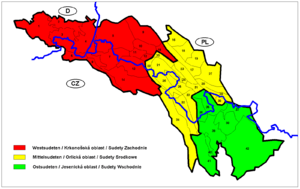
The Eastern Sudetes (Polish: Sudety Wschodnie, Czech: Východní Sudety or Jesenická oblast) are the Eastern part of the Sudetes mountains on the border of the Czech Republic and Poland. They stretch from the Kłodzko Valley and the Nysa Kłodzka River in the west down to the Moravian Gate in the east, leading to the Outer Western Carpathians.
Subdivision
The Eastern Sudetes consist of:
- Golden Mountains
- Śnieżnik Mountains
- Opawskie Mountains (Polish: Góry Opawskie) or Zlatohorská Highlands (Czech: Zlatohorská vrchovina)
- Hrubý Jeseník (High Ash Mountains)
- Hanušovická vrchovina (Hanušovice Highlands)
- Mohelnická brázda (Mohelnice depression)
- Zábřežská vrchovina (Zábřeh Highlands)
- Nízký Jeseník
Silesia topics | |||||||||||||||||||||||||||||||||||||||||||||||
|---|---|---|---|---|---|---|---|---|---|---|---|---|---|---|---|---|---|---|---|---|---|---|---|---|---|---|---|---|---|---|---|---|---|---|---|---|---|---|---|---|---|---|---|---|---|---|---|
| |||||||||||||||||||||||||||||||||||||||||||||||
| |||||||||||||||||||||||||||||||||||||||||||||||
| |||||||||||||||||||||||||||||||||||||||||||||||
| |||||||||||||||||||||||||||||||||||||||||||||||
| |||||||||||||||||||||||||||||||||||||||||||||||
This article is issued from Wikipedia - version of the 10/18/2014. The text is available under the Creative Commons Attribution/Share Alike but additional terms may apply for the media files.