Eckert, Colorado
| Eckert, Colorado | |
|---|---|
| Neighborhood | |
 Eckert  Eckert | |
| Coordinates: 38°50′34″N 107°57′41″W / 38.84278°N 107.96139°WCoordinates: 38°50′34″N 107°57′41″W / 38.84278°N 107.96139°W | |
| Country |
|
| State |
|
| Counties | Delta[1] |
| Elevation[1] | 5,568 ft (1,697 m) |
| Time zone | MST (UTC-7) |
| • Summer (DST) | MDT (UTC-6) |
| ZIP code[2] | 81418 |
| Area code(s) | 970 |
| Highways |
|
Eckert is a former unincorporated community, now a neighborhood within the boundaries of the incorporated town of Orchard City in Delta County, Colorado, United States. There is a U.S. Post Office in Eckert, the ZIP Code for which is 81418.[2]
A post office called Eckert has been in operation since 1891.[3] The community was named after the maiden name of the wife of a local merchant.[4]
Geography
Eckert is located at 38°50′34″N 107°57′41″W / 38.84278°N 107.96139°W (38.842649,-107.961273).
References
- 1 2 "US Board on Geographic Names". United States Geological Survey. 2007-10-25. Retrieved 2008-01-31.
- 1 2 "ZIP Code Lookup" (JavaScript/HTML). United States Postal Service. December 15, 2006. Retrieved December 15, 2006.
- ↑ "Post offices". Jim Forte Postal History. Retrieved 25 June 2016.
- ↑ Dawson, John Frank. Place names in Colorado: why 700 communities were so named, 150 of Spanish or Indian origin. Denver, CO: The J. Frank Dawson Publishing Co. p. 19.
Municipalities and communities of Delta County, Colorado, United States | ||
|---|---|---|
| City | 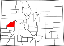 | |
| Towns | ||
| Unincorporated communities | ||
This article is issued from Wikipedia - version of the 7/31/2016. The text is available under the Creative Commons Attribution/Share Alike but additional terms may apply for the media files.