Effects of Hurricane Georges in Florida
| Category 2 hurricane (SSHWS/NWS) | |
 Hurricane Georges near the Florida Keys on September 25 | |
| Winds |
1-minute sustained: 105 mph (165 km/h) |
|---|---|
| Fatalities | None reported (7 injuries) |
| Damage | $472.1 million (1998 USD) |
| Areas affected | Florida Keys, South Florida, Florida Panhandle |
| Part of the 1998 Atlantic hurricane season | |
The effects of Hurricane Georges in Florida included $472.1 million in damages over a seven-day span.
Background
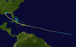
Hurricane Georges began as a tropical wave that moved off the coast of Africa during mid-September 1998. Tracking westward, the wave spawned an area of low pressure two days later, which quickly strengthened into a tropical depression. On September 16, the depression was upgraded into Tropical Storm Georges and further into Hurricane Georges the next day. The storm reached its peak intensity on September 20 with winds of 155 mph (250 km/h), just below Category 5 status on the Saffir-Simpson Hurricane Scale.[1]
Over the following five days, the hurricane tracked through the Greater Antilles, causing over 600 fatalities, mainly in the Dominican Republic and Haiti. By September 25, Georges entered the Gulf of Mexico as a Category 2 hurricane. The storm made landfall three days later near Biloxi, Mississippi with winds of 105 mph (165 km/h). Upon landfall, the hurricane's forward motion slowed to an eastward drift. Georges dissipated on October 1 near the Atlantic coast of Florida.[1]
Preparations
Initial forecasts of a southeastern Florida landfall resulted in the evacuation of over 1.2 million residents, including much of the Florida Keys. Despite the mandatory evacuation order, 20,000 people, including over 7,000 Key West citizens, refused to leave. Some of those who remained to ride out the storm were shrimpers, whose boats were their entire livelihood. Insurance companies refused to insure some of the older shrimp boats, leading shrimpers to ride it out with all they had left.[2] Due to lack of law enforcement, those who stayed in Key West went through red lights, double-parked, and disobeyed traffic laws. Long-time Florida Keys citizens noted the solitude of the time and enjoyed the island for how it once was, rather than the large crowds of tourists.[3] In Miami-Dade, 100,000 residents evacuated from coastal areas, 13,000 of which stayed in local shelters.[4]
Impact
South Florida
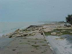
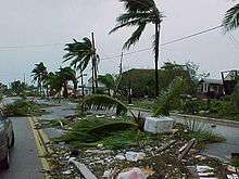
The eye of the storm passed near Key West about midday on September 24.[2] Upon making landfall, Hurricane Georges brought a storm surge of up to 12 feet (3.6 m) in Tavernier, Florida, with similar but lesser amounts along the Florida Keys.[2] Wind gusts near the center of the storm reached 125 mph (205 km/h).[5] The islands, some only 7 feet (2 m) high and 300 yards (275 m) wide, are easily flooded,[3] and with up to 10 foot (3 m) waves many parts of the Overseas Highway were under water. Strong winds downed palm trees and power lines, leaving all of the Keys without power. Georges's waves overturned 2 boats in Key West,[2] damaged 1,536 houses, and destroyed 173 homes, many of which were mobile homes. Rainfall amounts amounted to a maximum of 8.41 inches (210 mm) in Tavernier, while other locations reported lesser amounts.[6] Damage in the Florida Keys amounted to $200 million (1998 USD, $250 million 2009 USD).[7] A long-tracked F0 tornado, originally forming as a waterspout, caused moderate damage from Key Biscayne to Cutler Ridge.[8] Another F0 tornado briefly touched down near Miami, damaging cars and trees before lifting.[9] In Charlotte County another F0 tornado tracked for 5 mi (8.0 km), uprooting several trees along its path before dissipating.[10] On September 25, a waterspout moved onshore near Sebastian and severely damaged a factory; the tornado was rated F1 and caused $700,000 in damages.[11]
Further up the coast, the hurricane's outer bands produced light rainfall of up to 3 inches (80 mm).[6] Strong winds knocked down power lines, leaving 200,000 without power in the Miami area. Damage was minimal, and there were no reported casualties.[2]
Florida Panhandle
Upon making landfall, Hurricane Georges produced a storm surge of up to 10 feet (3 m), with higher waves on top of it. As it moved slowly through the northern Gulf Coast, it produced torrential rainfall amounting to a maximum of 38 inches (960 mm) in Munson, with other locations reporting over 20 inches (510 mm). Winds were light, peaking at 50 mph (80 km/h) along the coast, though Eglin Air Force Base recorded a gust of 90 mph (145 km/h). Outer squalls produced a tornado outbreak of 28 twisters, most of which occurred in northwestern Florida.[1]
Near Panama City, rough seas broke through the seawall and inundated waterfront buildings. Strong winds blew the roofs off several structures in the city.[12] An F1 tornado damaged several homes, causing $300,000 in damages, in Okaloosa County.[13] In Calhoun County flooding isolated up to 20 homes and roads were severely damaged. Widespread flooding in Walton County damaged numerous homes and businesses.[12] Flash flooding from local creeks inundated numerous homes, leaving $500,000 in damages.[14] High water near a levee threatened to break through and inundate a small town, resulting in the evacuation of 100 residents. Officials shut down 132 roads, including Interstate 10 due to flooding. Six homes were damaged in Gadsden County and many were left without power. Thirty roads and 20 bridges were washed out in Holmes County and an emergency evacuation of 300 residents was required. A chicken farm was flooded and 48,000 chickens drowned.[12] Damages to roadways in the county amounted to $1.3 million.[15] Flooding in Washington County caused $750,000 in damages to roads.[16]
Flooding in Jackson and Jefferson Counties shut down several roads and high winds downed numerous trees. Street flooding occurred throughout Tallahassee and many trees were downed. One tree fell on a power line and cut power to 1,800 residences in the city.[12] A brief F1 tornado in Bay County damaged 23 homes, causing $250,000 in damages.[17] Another F1 tornado caused substantial damage to a church and injured one person.[18] Numerous creeks and rivers rose near or above flood stage throughout northern Florida due to the torrential rainfall from Georges.[12] A strong F2 tornado touched down in Suwannee County, destroying seven homes and damaging five others. Five people were injured, two of which sustained serious injuries, and damages from the tornado amounted to $600,000.[19]
Damage amounted to $100 million (1998 USD, $127 million 2009 USD), though no deaths were reported.[7]
See also
References
- 1 2 3 John L. Guiney (January 5, 1999). "Hurricane Georges Tropical Cyclone Report". National Hurricane Center. Retrieved July 20, 2009.
- 1 2 3 4 5 Staff writer (September 26, 1998). "Hurricane Georges spares Florida ... for now". CNN (via the Wayback Machine). Archived from the original on December 23, 2006. Retrieved August 24, 2007.
- 1 2 Staff writer (September 24, 1998). "Widespread South Florida evacuation urged". CNN (via the Wayback Machine). Archived from the original on December 17, 2006. Retrieved August 24, 2007.
- ↑ Stuart Hinson (1999). "Florida Event Report: Tropical Storm". National Climatic Data Center. Retrieved June 11, 2009.
- ↑ Stuart Hinson (1999). "Florida Event Report: Waterspout". National Climatic Data Center. Retrieved July 20, 2009.
- 1 2 John L. Guiney (January 5, 1999). "Hurricane Georges Tropical Cyclone Report". National Hurricane Center. Retrieved April 21, 2009.
- 1 2 Staff writer (1998-10-02). "Gulf Coast damage estimates trickle in for Georges". CNN. Archived from the original on February 9, 2005. Retrieved 2007-08-24.
- ↑ Stuart Hinson (1999). "Florida Event Report: F0 Tornado". National Climatic Data Center. Retrieved July 20, 2009.
- ↑ Stuart Hinson (1999). "Florida Event Report: F0 Tornado". National Climatic Data Center. Retrieved July 20, 2009.
- ↑ Stuart Hinson (1999). "Florida Event Report: F0 Tornado". National Climatic Data Center. Retrieved July 20, 2009.
- ↑ Stuart Hinson (1999). "Florida Event Report: F1 Tornado". National Climatic Data Center. Retrieved July 20, 2009.
- 1 2 3 4 5 Stuart Hinson (2009). "Florida Event Report: Hurricane". National Climatic Data Center. Retrieved July 20, 2009.
- ↑ Stuart Hinson (1999). "Florida Event Report: F1 Tornado". National Climatic Data Center. Retrieved July 21, 2009.
- ↑ Stuart Hinson (1999). "Florida Event Report: Flash Flood". National Climatic Data Center. Retrieved July 21, 2009.
- ↑ Stuart Hinson (1999). "Florida Event Report: Flash Flood". National Climatic Data Center. Retrieved July 21, 2009.
- ↑ Stuart Hinson (199). "Florida Event Report: Flash Flood". National Climatic Data Center. Retrieved July 21, 2009.
- ↑ Stuart Hinson (1999). "Florida Event Report: F1 Tornado". National Climatic Data Center. Retrieved July 21, 2009.
- ↑ Stuart Hinson (1999). "Florida Event Report: F1 Tornado". National Climatic Data Center. Retrieved July 21, 2009.
- ↑ Stuart Hinson (1999). "Florida Event Report: F2 Tornado". National Climatic Data Center. Retrieved July 21, 2009.
External links
| Effects by region | ||
|---|---|---|