El Pinacate y Gran Desierto de Altar Biosphere Reserve
| Reserva de la Biosfera El Pinacate y Gran Desierto de Altar | |
|---|---|
|
IUCN category V (protected landscape/seascape) | |
|
Aerial view of El Pinacate y Gran Desierto de Altar Biosphere Reserve | |
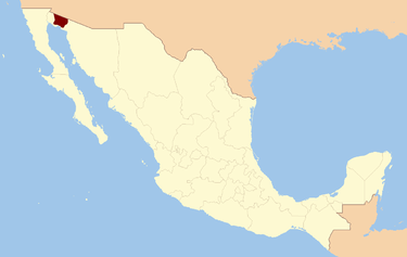 Location of the Reserve in Mexico | |
| Location | Sonora, Mexico |
| Nearest city |
Puerto Peñasco Plutarco Elías Calles San Luis Río Colorado |
| Coordinates | 32°00′N 113°55′W / 32.000°N 113.917°W[1]Coordinates: 32°00′N 113°55′W / 32.000°N 113.917°W[1] |
| Area | 7,146 km2 (2,759 sq mi) |
| Established | June 10, 1993 |
| Governing body | Instituto Nacional de Ecología and Tohono O'odham |
| http://elpinacate.conanp.gob.mx | |
| Official name | El Pinacate and Gran Desierto de Altar Biosphere Reserve |
| Type | Natural |
| Criteria | vii, viii, x |
| Designated | 2013 (37th session) |
| Reference no. | 1410 |
| State Party | Mexico |
| Region | Latin America and the Caribbean |
| Official name | Agua Dulce |
| Designated | February 2, 2008[2] |


El Pinacate y Gran Desierto de Altar Biosphere Reserve (Spanish: Reserva de la Biosfera El Pinacate y Gran Desierto de Altar), is a biosphere reserve and UNESCO World Heritage Site[1] managed by the Federal government of Mexico, specifically by Secretariat of the Environment and Natural Resources, in collaboration with state government of Sonora and the Tohono O'odham.
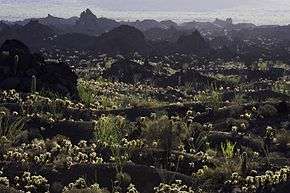
It is in the Sonoran Desert in Northwest Mexico, east of Gulf of California, in the eastern part Gran Desierto de Altar, just below the border of Arizona, United States and north of the city of Puerto Peñasco. It is one of the most significant visible landforms in North America seen from space. A volcanic system, known as Santa Clara is the main part of the landscape, including three peaks; Pinacate, Carnegie and Medio.
In the area there are over 540 species of plants, 40 species of mammals, 200 of birds, 40 of reptiles, also amphibians and freshwater fishes.[3] There are threatened endemic species as sonoran pronghorn, bighorn sheep, gila monster and desert tortoise.[4]
The extension of the Biosphere Reserve is 7,146 km²,[5] greater than that of the states of Aguascalientes, Colima, Morelos and Tlaxcala separated.[6]
Formation
El Pinacate y Gran Desierto de Altar Biosphere Reserve is known for its unique physical and biological characteristics, by the presence of a volcanic shield, and by the extensive areas of active dunes that surround it, and the greatest concentration of Maar craters. The Pinacate Mountains range has orogenic features of high interest, products of volcanic eruptions that accumulated lava in compact rocks, sand and volcanic ashes that formed colors of special beauty, and craters such as El Elegante, Cerro Colorado, MacDougal, and Sykes.[7]
- Pinacate Peaks
The Pinacate Peaks (Picos del Pinacate), a group of volcanic peaks and cinder cones, are located in the Reserve north of Puerto Peñasco. The highest peak is Cerro del Pinacate (Santa Clara volcano), with an elevation of 3,904 feet (1,190 m). Pinacate comes from Náhuatl language word pinacatl, for the Pinacate beetle, a stink beetle endemic to the Sonoran Desert.
The Pinacate Peaks volcanoes have erupted sporadically for about 4 million years. The most recent activity was about 11 000 years ago.
NASA sent astronauts the Gran Desierto de Altar from 1965 to 1970, to train for walking on the moon, due to the similarities of the terrain to the lunar surface.
History

Pre-Columbian era
The first inhabitants are known as San Dieguito people, they were hunter-gatherer who lived off the land, moving from the mountains to the sea of Gulf of California looking for food. The early stages of occupation seem to have ended at the beginning of ice age about 20 thousand years ago, when drought forced people to leave the mountain range.[8]
A second stage of occupation by San Dieguito people began in the late glacial period. This group returned to the mountains and lived as their ancestors had. Tinajas must have been a reliable source of water during this time. The second stage of occupation ended with the arrival of an antipyretic period 9000 years ago, which again forced the people to leave the territory.[3]
The most recent indigenous inhabitants of the Pinacate and Gran Desierto de Altar are the Pinacateño band of the Hia C-ed O'odham. Like the prehistoric San Dieguito culture, the Pinacateños roamed the Pinacate all the way to the sea in search of food, concentrating their camps near the tinajas. During these voyages, they left signs of their presence; one example of this is the network of paths that go from tinaja to tinaja, as well as the stone tools and potsherds found near these water sources.[3][9]
Explorations
There are few records of those who were the first explorers in this area. Possibly the first white man to see the mountain now known as Sierra Pinacate was the explorer Melchior Díaz on 1540. Subsequently, on 1698 the priest Eusebio Kino, founder of Mission San Xavier del Bac in southern Tucson, Arizona, visited the site and returned on several occasions, he and his group climbed to the top of El Pinacate, which named Santa Clara Hill.[3]
Before 1956, few scientists and explorers had been in El Pinacate y Gran Desierto de Altar, the most famous, the group MacDougal, Hornaday and Sykes who explored the western part of the mountain on 1907.
References
- 1 2 3 UNESCO. "El Pinacate and Gran Desierto de Altar Biosphere Reserve". Retrieved June 24, 2013.
- ↑ "Ramsar List". Ramsar.org. Retrieved 11 April 2013.
- 1 2 3 4 Comisión Nacional de Áreas Naturales Protegidas. "Reserva de la Biosfera El Pinacate y Gran Desierto de Altar". Retrieved September 29, 2010.
- ↑ Red Escolar. "Reserva de la Biosfera El Pinacate y Gran Desierto de Altar". Retrieved September 29, 2010.
- ↑ Comisión Nacional para el Conocimiento
y Uso de la Biodiversidad. "Regiones terrestres prioritarias de México" (PDF). Retrieved September 29, 2010. line feed character in
|author=at position 40 (help) - ↑ INEGI. "Información por entidad".
- ↑ Instituto Nacional de Ecología. "Reserva de la Biosfera El Pinacate y Gran Desierto de Altar". Retrieved September 29, 2010.
- ↑ Hayden, 1998.
- ↑ "Pinacate y Gran Desierto de Altar". Red Escolar. Retrieved September 29, 2010.
External links
- Official Pinacate y Gran Desierto de Altar Biosphere Reserve website
- Volcano.si.edu: Global Volcanism Program—Pinacate
- NASA: Satellite photo of Volcán Pinacate
- Azcentral.com: "Sierra Pinacate a Volcanic Wonder"
| Wikimedia Commons has media related to El Pinacate y Gran Desierto de Altar. |
| North West |
| |
|---|---|---|
| North Central |
| |
| West |
| |
| East |
| |
| South West |
| |
| South Central |
| |
| South East |
| |
| ||