Ella, Oregon
| Ella, Oregon | |
|---|---|
| Unincorporated community | |
 Ella, Oregon  Ella, Oregon | |
| Coordinates: 45°37′52″N 119°48′32″W / 45.63111°N 119.80889°WCoordinates: 45°37′52″N 119°48′32″W / 45.63111°N 119.80889°W | |
| Country | United States |
| State | Oregon |
| County | Morrow |
| Elevation | 810 ft (250 m) |
| Time zone | Pacific (PST) (UTC-8) |
| • Summer (DST) | PDT (UTC-7) |
| Area code(s) | 458 and 541 |
| GNIS feature ID | 1136257[1] |
| Coordinates and elevation from the Geographic Names Information System (GNIS)[1] | |
Ella is an unincorporated community in Morrow County, Oregon, United States. Ella lies along Immigrant Lane and the Oregon Trail east of Cecil and south of Boardman.[2]
Well Spring, mentioned in many immigrant journals, is 5 miles (8 km) east of Ella along the trail. About 4 miles (6 km) south of Ella is a landform known to immigrants as Well Spring Butte but later renamed Ella Butte.[3]
Ella had a post office from April 24, 1882, through September 30, 1910. Established at the home of Frank Oviatt, it was named for his daughter Ella, who was told it would be named for her if she stopped crying during a post office planning session. Oviatt became the first postmaster.[3]
References
- 1 2 "Ella". Geographic Names Information System. United States Geological Survey. November 28, 1980. Retrieved October 20, 2016.
- ↑ Oregon Atlas & Gazetteer (7th ed.). Yarmouth, Maine: DeLorme. 2008. p. 73. ISBN 978-0-89933-347-2.
- 1 2 McArthur, Lewis A.; Lewis L. McArthur (2003) [1928]. Oregon Geographic Names (7th ed.). Portland, Oregon: Oregon Historical Society Press. pp. 326–27. ISBN 0-87595-277-1.
Municipalities and communities of Morrow County, Oregon, United States | ||
|---|---|---|
| Cities | 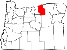 | |
| Unincorporated communities | ||
| Ghost town | ||
This article is issued from Wikipedia - version of the 10/21/2016. The text is available under the Creative Commons Attribution/Share Alike but additional terms may apply for the media files.