Elverum
| Elverum kommune | |||
|---|---|---|---|
| Municipality | |||
|
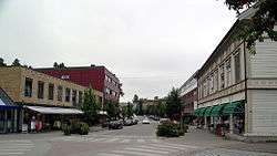
Elverum in 2006 | |||
| |||
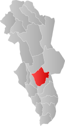 Elverum within Hedmark | |||
| Coordinates: 60°55′39″N 11°42′55″E / 60.92750°N 11.71528°ECoordinates: 60°55′39″N 11°42′55″E / 60.92750°N 11.71528°E | |||
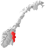
| Country | Norway | ||
| County | Hedmark | ||
| District | Østerdalen | ||
| Administrative centre | Elverum | ||
| Government | |||
| • Mayor (2011) | Erik Hanstad (H) | ||
| Area | |||
| • Total | 1,229 km2 (475 sq mi) | ||
| • Land | 1,209 km2 (467 sq mi) | ||
| Area rank | 80 in Norway | ||
| Population (01.01.2016) | |||
| • Total | 21,030 | ||
| • Rank | 52 in Norway | ||
| • Density | 17.1/km2 (44/sq mi) | ||
| • Change (10 years) | 10.7 % | ||
| Demonym(s) |
Elverumsing Elverumsokning[1] | ||
| Time zone | CET (UTC+1) | ||
| • Summer (DST) | CEST (UTC+2) | ||
| ISO 3166 code | NO-0427 | ||
| Official language form | Neutral | ||
| Website |
www | ||
|
| |||
![]() Elverum is a town and municipality in Hedmark county, Norway. It is part of the traditional region of Østerdalen. The administrative centre of the municipality is the town of Elverum. The municipality of Elverum was established on 1 January 1838 (see formannskapsdistrikt).
Elverum lies at an important crossroads, with Hamar to the west, Kongsvinger to the south, and Trysil on the Swedish border to the northeast. It is bordered on the north by Åmot municipality, in the northeast by Trysil municipality, in the southeast by Våler, and in the west by Løten. [2]
Elverum is a town and municipality in Hedmark county, Norway. It is part of the traditional region of Østerdalen. The administrative centre of the municipality is the town of Elverum. The municipality of Elverum was established on 1 January 1838 (see formannskapsdistrikt).
Elverum lies at an important crossroads, with Hamar to the west, Kongsvinger to the south, and Trysil on the Swedish border to the northeast. It is bordered on the north by Åmot municipality, in the northeast by Trysil municipality, in the southeast by Våler, and in the west by Løten. [2]
General information
The name
The municipality (originally the parish) is named after the old Elverum farm (Old Norse: Alfarheimr), since the first church was built here. The first element is the genitive case of elfr which means "river" (here the Glomma river) and the last element is heimr which means "home/homestead" or "farm".
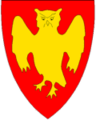
Coat-of-arms
The coat-of-arms is from modern times. They were granted on 9 December 1988. The arms show a gold-colored owl on a red field. This was chosen as a symbol for wisdom since there are many schools in the municipality. The owl also seems somewhat aggressive, to represent the fighting spirit of Norwegians. In 1940, when Norway was under attack from the German forces, King Haakon VII received the power from the parliament to govern the country, in its best interests while he was in Elverum.[3][4]
History
Military ties
During the Nordic Seven Years' War (1563–1570), Swedish troops invaded Norway in a number of locations, including a number of incursions into Østerdalen. In 1563, Norwegian troops stopped the Swedish advance at Elverum, which provided a strategic point since it lay on both north-south and east-west trade and travel routes.
The parishes of Idre and Särna originally belonged to Elverum. But they were occupied by Swedish troops in 1644, and since then lost to Sweden.
Construction of fortifications started in 1673 during the Gyldenløve War as Hammersberg Skanse (also referred to as Terningen Skanse); the bastion of which is still preserved today. It was renamed Christiansfjell Fortress in 1685 by King Christian V of Denmark during his visit to Hammersberg Skanse on June 14. Although the fortress was manned through the Great Northern War, the city was spared major battles. In 1742, Christiansfjell Fortress was closed.
A Norwegian infantry regiment, the Oppland Regiment, was formed in 1657 and Elverum became a garrison town. The area of population east of the river called Leiret (literally the camp) adjacent to Christiansfjell Fortress was built up by soldiers as well as the merchants and craftsmen who settled nearby. Even to this day the area of Elverum central areas east of the river is referred to as Leiret.
In 1878, Terningmoen at Elverum became the home base for the Oppland Regiment and an infantry school was founded here in 1896.
The Oppland Regiment had a history which included courageous involvement in combat from the Swedish wars of the 17th century through the German invasion of Norway in 1940. As part of the general restructuring, the unit was disbanded in 2002.
Today, Terningmoen hosts several sub units within the Norwegian army and the Home guard.
Regional town
In the Danish-Norwegian period, Elverum was the location for a bailiff (fogd), a judge (sorenskriver), a head pastor (prost), and numerous military officers.
It became important as a market town as well. In 1570 Hamar Cathedral in Hamar was burned and Hamarhus castle was destroyed by the Swedish armies during the Seven Years' War with Sweden. Hamar lost its city status, leaving no kjøpstad, or official market city, between Christiania and Trondheim. Eastern Norway needed an organized market for trading goods. The Grundset market (Grundsetmart'n) in Elverum municipality grew to meet the need. It is recorded as existing in the 17th century, and in 1765 the owner of Gaarder obtained special market privileges from the king, to take place six miles north of the population center of Elverum on his estate. By 1767, it was described as Norway's largest and most famous market. In the first week of March, for almost 300 years, the folks of the district met to trade and to celebrate. People from Gudbrandsdal, Oslo, Trøndelag, and Sweden also regularly came to Grundsetmart'n. The Grundset market was finally abandoned in 1901, when pressures of the railroad and other markets made it superfluous.

The railway connecting Oslo and Trondheim passed through Elverum in 1877.
World War II
Elverum municipality served as a temporary capital of Norway during the World War II German invasion. On 9 April 1940 Norwegian troops prevented German parachute troops from capturing Norway's King Haakon, Crown Prince, and Parliament while the Parliament was meeting to issue the Elverum Authorization, authorizing the exiled government until the Parliament could again convene. On April 11, shortly after the government's refusal to submit to German terms, the center of Elverum was reduced to ashes.
Museums
Norwegian Forest Museum
The Norwegian Forest Museum is a national museum recognizing the importance of forestry, hunting, and fishing to the Norwegian history and economy.
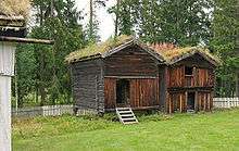
Glomdal Museum
From the eastern side of Glomma (the Museum of Norwegian Forestry - Skogmuseet), a pedestrian bridge across the Klokkerfoss waterfall to Prestøya, and then a bridge across the Prestfossen falls leads to the Glomdal Museum, one of the largest Norwegian outdoor museums, with numerous houses from the mountain parishes of Østerdalen and the lowland districts of Solør on the Glomma river valley. The exhibition includes a library with numerous books, including handwritten medieval manuscripts.
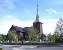
Elverum Church
Elverum church (Elverum kirke) is a cruciform church. Access to the site is via Fylkesvei 553 and Riksvei 2/ Riksvei 25. The church was built in 1736 and inaugurated in 1738. The edifice is of wood and has 700 seats. The church was greatly changed in 1878 under the leadership of architect Henrik Thrap-Meyer. In 1937-38, the interior from the 1700s was restored with the windows and entrance doors returned to the original shape. The decorative leaf decor in the chancel was completed and galleries reconstructed.[5]
Notable residents
The following people were born and raised in Elverum
- Tord Øverland-Knudsen, Musician and Bass Player of The Wombats
- Hans Anton Aalien, blind gold medalist in the disabled skiing at the 1988 Winter Olympics
- Brita Møystad Engseth, film reviewer and journalist
- Stig Inge Bjørnebye, former professional football player for Liverpool and Blackburn Rovers
- Bjørn Dæhlie, cross-country skier with most world medals (29 medals in the Olympics and World Championships) and Winter Olympic record of 8 gold and 4 silver medals
- Dagfinn Grønoset, journalist, author and winner of HM The King's Medal of Merit (gold) in 1989
- Marie Hamsun, Knut Hamsuns second wife
- Roy Khan, former lead singer of the music group Kamelot
- Carl Oscar Munthe, military officer and historian
- Gerhard Munthe, painter and illustrator
- Hartvig Andreas Munthe, military engineer and genealogist
- Stener Johannes Stenersen, veterinarian and author of first monograph on the Fjord horse
- Marius Drogsås Hagen, Bjarne Alexander Ryen Berg and Simen Sandbæk Skari from Team Me
- Marcus & Martinus Singing Duo
International relations
Twin towns — Sister cities
The following cities are twinned with Elverum:[6]
-
 - Haslev, Region Sjælland, Denmark
 -
 - Tsumeb, Oshikoto Region, Namibia
 -
 - Siilinjärvi, Itä-Suomi, Finland
 -
 - Sunne, Värmland County, Sweden
References
- ↑ "Navn på steder og personer: Innbyggjarnamn" (in Norwegian). Språkrådet. Retrieved 2015-12-01.
- ↑ Morten Haugen. "Elverum". Store norske leksikon. Retrieved October 1, 2016.
- ↑ Norske Kommunevåpen (1990). "Nye kommunevåbener i Norden". Retrieved 2008-12-21.
- ↑ "Kommunevåpnet" (in Norwegian). Elverum kommune. Retrieved 2008-12-21.
- ↑ "Elverum Kirke". Den norske kirke. Retrieved October 1, 2016.
- ↑ "Vennskapsbyer" (in Norwegian). Elverum kommune. Retrieved 2008-12-21.
External links
| Wikimedia Commons has media related to Elverum. |
| Look up Elverum in Wiktionary, the free dictionary. |
- Municipal fact sheet from Statistics Norway
- Municipal website (Norwegian)
As of 1 January 2014, according to Statistics Norway | ||||||||||||||||||||||||||||||||||||||||||||||||||||||||
|  | |||||||||||||||||||||||||||||||||||||||||||||||||||||||