Enfield, New Hampshire
| Enfield, New Hampshire | ||
|---|---|---|
| Town | ||
|
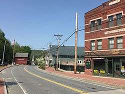
Main Street in Enfield, 2016 | ||
| ||
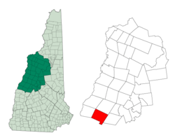 Location in Grafton County, New Hampshire | ||
| Coordinates: 43°38′30″N 72°08′43″W / 43.64167°N 72.14528°WCoordinates: 43°38′30″N 72°08′43″W / 43.64167°N 72.14528°W | ||
| Country | United States | |
| State | New Hampshire | |
| County | Grafton | |
| Incorporated | 1761 | |
| Government | ||
| • Board of Selectmen |
John W. Kluge B. Fred Cummings Meredith C. Smith | |
| • Town Manager | Steve Schneider | |
| Area | ||
| • Total | 43.1 sq mi (111.6 km2) | |
| • Land | 40.3 sq mi (104.3 km2) | |
| • Water | 2.9 sq mi (7.4 km2) | |
| Elevation | 778 ft (237 m) | |
| Population (2010) | ||
| • Total | 4,582 | |
| • Density | 114/sq mi (43.9/km2) | |
| Time zone | Eastern (UTC-5) | |
| • Summer (DST) | Eastern (UTC-4) | |
| ZIP code | 03748 | |
| Area code(s) | 603 | |
| FIPS code | 33-24340 | |
| GNIS feature ID | 0873590 | |
| Website |
www | |
Enfield is a town in Grafton County, New Hampshire, United States. The population was 4,582 at the 2010 census.[1] The town includes the villages of Enfield, Enfield Center, Upper Shaker Village, Lower Shaker Village, Lockehaven, and Montcalm.
The primary settlement in town, where 1,540 people resided at the 2010 census,[2] is defined as the Enfield census-designated place (CDP) and includes the main village of Enfield, centered on U.S. Route 4 and the inlet of the Mascoma River into Mascoma Lake.
History
The town was incorporated in 1761 by Colonial Governor Benning Wentworth. First named Enfield by settlers from Enfield, Connecticut, the town was renamed Relhan in 1766 to honor Dr. Anthony Relhan (ca. 1715-1776). The doctor was a promoter of sea-bathing as a curative, making Brighton, England, a fashionable resort. Following the American Revolution, the New Hampshire town was renamed Enfield in 1784.[3]
The first European settlers in town were Jonathan Paddleford and family who arrived, after the successful conclusion of the French and Indian War, between 1765 and 1772.[4]
On the southwest shore of Mascoma Lake is Enfield Shaker Village, once a utopian religious community of Shakers, renowned for simple and functional architecture and furniture. Established in 1793 and called Chosen Vale, the village was subdivided into several "Families", with men and women leading pious, celibate and industrious lives. Although the genders shared dormitories, like Enfield's Great Stone Dwelling built between 1837 and 1841, the sexes used separate doors and stairways. They practiced ecstatic singing and dancing, an expression of their worship, which earned them the appellation: Shaking Quakers, or Shakers.
Several trades operated at the village, from agriculture and packaging of seeds, to manufacture of brooms, brushes, spinning-wheels, and furniture. To speed delivery of products to the railroad across Mascoma Lake, in 1849 the community erected Shaker Bridge.
The Shaker movement crested in the 1840s, with 19 "societies" scattered from Maine to Kentucky and west to Indiana. But growing employment opportunities created by the Industrial Revolution, as near as the mill town of Lebanon, enticed away potential and practicing church members. Others grew disaffected with celibacy, self-abnegation, and communal ownership of property. Indeed, Mary Marshall Dyer, once a member of the Enfield church, became an outspoken Anti-Shaker. Eventually the village would close and, in 1927, be sold to the La Salette Brotherhood of Montreal, a Catholic order noted for its Christmas display. In 1986, Enfield Shaker Village was established as a museum.
-

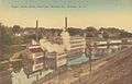
Enfield c. 1908
-
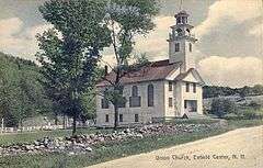
Centre Village Meeting House in 1909
-

Shaker Bridge in 1908
-
Baltic Mills in 1908
Geography
According to the United States Census Bureau, the town has a total area of 43.1 square miles (111.6 km2), of which 40.3 sq mi (104.3 km2) is land and 2.9 sq mi (7.4 km2) is water, comprising 6.59% of the town.[1] Enfield is drained by the Mascoma River. Mascoma Lake, in the west, represents Enfield's lowest elevation at 751 feet (229 m) above sea level. The highest elevation is over 2,100 ft (640 m) at the summit of Prospect Hill, overlooking Halfmile Pond. Crystal Lake is in the east. Enfield lies fully within the Connecticut River watershed.[5]
The village area of the town, defined as a census-designated place (CDP), has a total area of 2.33 square miles (6.03 km2), of which 2.27 sq mi (5.87 km2) is land and 0.06 sq mi (0.15 km2), or 2.56%, is water.[2]
Enfield is served by Interstate 89, U.S. Route 4, New Hampshire Route 4A and New Hampshire Route 10.
Demographics
| Historical population | |||
|---|---|---|---|
| Census | Pop. | %± | |
| 1790 | 724 | — | |
| 1800 | 1,121 | 54.8% | |
| 1810 | 1,291 | 15.2% | |
| 1820 | 1,370 | 6.1% | |
| 1830 | 1,492 | 8.9% | |
| 1840 | 1,514 | 1.5% | |
| 1850 | 1,742 | 15.1% | |
| 1860 | 1,876 | 7.7% | |
| 1870 | 1,662 | −11.4% | |
| 1880 | 1,680 | 1.1% | |
| 1890 | 1,439 | −14.3% | |
| 1900 | 1,845 | 28.2% | |
| 1910 | 1,448 | −21.5% | |
| 1920 | 1,577 | 8.9% | |
| 1930 | 1,325 | −16.0% | |
| 1940 | 1,693 | 27.8% | |
| 1950 | 1,612 | −4.8% | |
| 1960 | 1,867 | 15.8% | |
| 1970 | 2,345 | 25.6% | |
| 1980 | 3,175 | 35.4% | |
| 1990 | 3,979 | 25.3% | |
| 2000 | 4,618 | 16.1% | |
| 2010 | 4,582 | −0.8% | |
| Est. 2015 | 4,550 | [6] | −0.7% |
As of the census of 2010, there were 4,582 people, 2,044 households, and 1,305 families residing in the town. The population density was 113.7 persons per square mile (43.9/km²). There were 2,508 housing units at an average density of 24.0/km² (62.2/sq mi). The racial makeup of the town was 96.8% white, 0.4% African American, 0.3% Native American or Alaska Native, 0.9% Asian, 0.0% Pacific Islander, 0.2% some other race, and 1.4% from two or more races. 1.2% of the population were Hispanic or Latino of any race.[8]
There were 2,044 households, out of which 24.1% had children under the age of 18 living with them, 50.1% were headed by married couples living together, 8.9% had a female householder with no husband present, and 36.2% were non-families. 27.7% of all households were made up of individuals, and 7.0% were someone living alone who was 65 years of age or older. The average household size was 2.24, and the average family size was 2.70.[8]
In the town the population was spread out with 19.4% under the age of 18, 6.1% from 18 to 24, 26.8% from 25 to 44, 33.8% from 45 to 64, and 13.9% who were 65 years of age or older. The median age was 43.6 years. For every 100 females there were 94.6 males. For every 100 females age 18 and over, there were 93.1 males.[8]
For the period 2009-2013, the estimated median annual income for a household in the town was $80,038, and the median income for a family was $89,362. Male full-time workers had a median income of $53,061 versus $43,456 for females. The per capita income for the town was $45,653. 3.1% of the population and 1.2% of families were below the poverty line. 2.3% of people under the age of 18 and 2.2% of people 65 or older were living in poverty.[9]
Town center
As of the census of 2010, there were 1,540 people, 712 households, and 419 families residing in the central settlement, or CDP. The population density was 678.4 persons per square mile (262.4/km²). There were 787 housing units at an average density of 134.1/km² (346.7/sq mi). The racial makeup of the town was 96.4% white, 0.6% African American, 0.1% Native American or Alaska Native, 0.5% Asian, 0.4% some other race, and 1.9% from two or more races. 1.4% of the population were Hispanic or Latino of any race.[10]
There were 712 households, out of which 28.1% had children under the age of 18 living with them, 40.7% were headed by married couples living together, 13.1% had a female householder with no husband present, and 41.2% were non-families. 34.1% of all households were made up of individuals, and 10.0% were someone living alone who was 65 years of age or older. The average household size was 2.16, and the average family size was 2.75.[10]
In the CDP the population was spread out with 21.4% under the age of 18, 8.2% from 18 to 24, 27.6% from 25 to 44, 27.5% from 45 to 64, and 15.3% who were 65 years of age or older. The median age was 39.7 years. For every 100 females there were 89.0 males. For every 100 females age 18 and over, there were 86.7 males.[10]
For the period 2009-2013, the estimated median annual income for a household in the CDP was $77,303, and the median income for a family was $89,524. Male full-time workers had a median income of $40,214 versus $42,647 for females. The per capita income for the CDP was $44,913.[11]
Sites of interest
- Enfield Shaker Museum
- Shaker Historic Trail, Enfield
- Lockhaven Schoolhouse Museum
Notable people
- Robert O. Blood, physician and the 65th governor of New Hampshire
- Jacob Cochran, preacher
- William Goodhue Perley, businessman and member of the Canadian House of Commons
- Stan Williams, pitcher with six MLB teams
References
- 1 2 "Geographic Identifiers: 2010 Census Summary File 1 (G001): Enfield town, Grafton County, New Hampshire". U.S. Census Bureau, American Factfinder. Retrieved April 15, 2015.
- 1 2 "Geographic Identifiers: 2010 Census Summary File 1 (G001): Enfield CDP, New Hampshire". U.S. Census Bureau, American Factfinder. Retrieved April 15, 2015.
- ↑ Coolidge, Austin J.; John B. Mansfield (1859). A History and Description of New England. Boston, Massachusetts. pp. 484–485.
- ↑ "New Hampshire Search Roots". History of Enfield, Grafton County, New Hampshire. Retrieved 2007-01-02.
- ↑ Foster, Debra H.; Batorfalvy, Tatianna N.; Medalie, Laura (1995). Water Use in New Hampshire: An Activities Guide for Teachers. U.S. Department of the Interior and U.S. Geological Survey.
- ↑ "Annual Estimates of the Resident Population for Incorporated Places: April 1, 2010 to July 1, 2015". Retrieved July 2, 2016.
- ↑ "Census of Population and Housing". Census.gov. Retrieved June 4, 2016.
- 1 2 3 "Profile of General Population and Housing Characteristics: 2010 Census Summary File 1 (DP-1): Enfield town, Grafton County, New Hampshire". U.S. Census Bureau, American Factfinder. Retrieved April 15, 2015.
- ↑ "Selected Economic Characteristics: 2010 Census Summary File 1 (DP03): Enfield town, Grafton County, New Hampshire". U.S. Census Bureau, American Factfinder. Retrieved April 15, 2015.
- 1 2 3 "Profile of General Population and Housing Characteristics: 2010 Census Summary File 1 (DP-1): Enfield CDP, New Hampshire". U.S. Census Bureau, American Factfinder. Retrieved April 15, 2015.
- ↑ "Selected Economic Characteristics: 2010 Census Summary File 1 (DP03): Enfield CDP, New Hampshire". U.S. Census Bureau, American Factfinder. Retrieved April 15, 2015.
External links
- Town of Enfield official website
- Enfield Public Library
- New Hampshire Economic and Labor Market Information Bureau Profile
