Erattupetta
| Erattupetta ഈരാറ്റുപേട്ട | |
|---|---|
| Municipality | |
|
Town's junction | |
 Erattupetta Location in Kerala, India | |
| Coordinates: 9°42′N 76°47′E / 9.7°N 76.78°ECoordinates: 9°42′N 76°47′E / 9.7°N 76.78°E | |
| Country |
|
| State | Kerala |
| District | Kottayam |
| Founded by | Kerala govt |
| Government | |
| • Type | Municipality |
| • Municipal chairman | T. M. Rasheed |
| Area | |
| • Total | 14.24 km2 (5.50 sq mi) |
| Elevation | 24 m (79 ft) |
| Population (2011) | |
| • Total | 29,675 |
| • Density | 2,100/km2 (5,400/sq mi) |
| Languages | |
| • Official | Malayalam, English |
| Time zone | IST (UTC+5:30) |
| PIN | 686121 |
| Vehicle registration | KL-35 |
| Literacy | 90% |
| Website | http://lsgkerala.in/erattupettapanchayat/ |
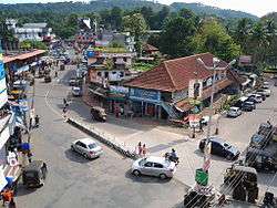
Erattupetta (Malayalam: ഈരാറ്റുപേട്ട) is a Municipality town in Kottayam district in the state of Kerala, India. It is 38 km east of Kottayam, the district Centre. Erattupetta was known as Erappili and Erappuzha before.
Etymology
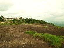
The "Eraaru" part in all the variation of the names arose from the geographical location, where the two rivers (aru) merge as single one. Erattupetta is situated in the foothills of High Ranges. It was the commercial capital of the Poonjar principality until 1949. Erattupetta lies in an ancient route from Athirampuzha to Tamil Nadu.
Economy
Hill produce from the Cardamom hills were brought down by the Muthuvans for trade. Erattupetta's current economy is primarily rubber and scores of large and small estates dot the landscape. Wagamon, a Hill Station, lies some 22 km east of Eruttupetta.
Demographics
As of 2001 India census,[1] Erattupetta had a population of 29,675. Males constitute 51% of the population and females 49%. Erattupetta has an average literacy rate of 80%, higher than the national average of 59.5%: male literacy is 83%, and female literacy is 76%. In Erattupetta, 14% of the population is under 6 years of age. Syrian Christians, Hindus and Muslims live here peacefully. Rubber is the major item of cultivation and this town is known as the mosque Nainar Juma masjid. It is one of the most fast developing townships in central Kerala. The population is predominantly Syrian Christian, Hindu and Muslim. The Syrian Christians of the region are entirely Catholic, belonging to the Palai diocese of the Syro Malabar Catholic church. They are mainly in farming, particularly of plantation crops such as Rubber, and are evenly spread across the country side surrounding the town. Many aristocratic Catholic Nasrani families of Central Travancore have their origins in Erattupetta, which has been an ancient stronghold of the community. Many such families have also migrated to places around Erattupetta, such as Poonjar, Teekoy etc. a century ago, as part of the agrarian expansion in Central Travancore.
Mosques
The Muslims of Erattupetta are Tamil Muslims who come from Tamil Nadu, centuries ago. They are mostly into trade related occupations and are considered different from The Mappila Muslims, which is a Malayali Muslim community, common in the central and northern half of Kerala. The Erattupetta Muslims reside in Thodupuzha and some parts of the Idukki and Pathanamthitta districts.
Families
Valiyaveettil (also known as "Methar") is one of the prominent Muslim families in Erattupetta.
Khan The Former royal family of Madurai came here in 11th century from Tamil Nadu. This place, which was under the control of the Thekkumkur king, transferred his power to the royal family of Madurai. For the stability of government they greeted sincere and able Muslim Nobles. Their next generation are known by the name as "KHAN". Today, the Khan family is a prominent Muslim family in Erattupetta. 'Lebbas are another Muslim family in Erattupetta and are claimed to be descendants of Shaikh Saeed Bava (a descendant of Ukasha bin Mihsan, a companion of Prophet Muhammed)
Churches
St. George's Church is an old famous pilgrimage centre, is situated in the suburbs of Erattupetta. The Church, is believed to be the oldest Church in eastern Kerala, and is the mother church of the ancient Syrian Christian community of both the Meenachil and the Kanjirapally Taluks. It is believed to be built by an early wave of migrant Christians from Nilackal (Chayal), who settled in the region for trade, commerce and agriculture. Nilackal, located in the Sabarimala hills miles Southeast of Erattupetta, is known to be one of the 7 centers in Kerala, where Saint Thomas founded Christian communities and established Churches. There's also a popular belief that the St. George's Church was established by Saint Thomas the apostle himself.
Geography
Erattupetta can be easily reachable from north Kerala via Angamaly-Muvattupuzha-Thodupuzha-Muttom route. It is well connected to Tamil Nadu via Kottayam-Kumali KK Road to Madurai through the nearest town Kanjirappally which is 16 Kilometres from Erattupetta. Many Famous Personalities hails from Erattupetta and nearby. PC Chacko, P C George, NM Joseph, Kerala Varma Raja are current or former political leaders. Social worker 'KS Kochuthampi' (express) also hails from this place.
Erattupetta is located at 9°42′N 76°47′E / 9.7°N 76.78°E.[2] It has an average elevation of 36 metres (118 feet).
Access
- Thiruvananthapuram - Kilimanoor - Kottarakkara - Pathanamthitta - Ranni - Erumeli - Kanjirappally - Chemmalamattam -Erattupetta
- Kottayam - Ettumanoor - Pala - Erattupetta
- Kochi/Cochin - Trhippunithura - Poothotta - Thalayolapparambu - Ettumanoor - Pala - Erattupetta
- trissur/trichur-chalakudy - ankamali - muvattupuzha - thodupuzha - erattupatta
Politics
Erattupetta is part of Poonjar assembly constituency.It is also a part of Pathanamthitta loksabha constituency.The current Member of Parliament is Anto Antony of INC.Poonjar was in the limelight during 2016 state elections when P.C. George, who was the sitting MLA, decided to contest the elections as an independent candidate, after being denied an LDF ticket. He defeated candidates of the major fronts, winning over a margin of over 27000 votes.
References
| Wikimedia Commons has media related to Erattupetta. |