Pathanamthitta
| Pathanamthitta പത്തനംതിട്ട | |
|---|---|
| Town | |
|
Aranmula Uthrattathi Boat Race | |
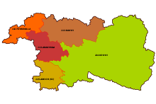
 Pathanamthitta  Pathanamthitta Location in Kerala, India | |
| Coordinates: 9°15′53″N 76°47′13″E / 9.2648°N 76.7870°ECoordinates: 9°15′53″N 76°47′13″E / 9.2648°N 76.7870°E | |
| Country |
|
| State | Kerala |
| District | Pathanamthitta |
| Founded by | K. K. Nair |
| Area | |
| • Total | 23.50 km2 (9.07 sq mi) |
| Elevation | 31 m (102 ft) |
| Population (2011) | |
| • Total | 37,538 |
| • Density | 1,600/km2 (4,100/sq mi) |
| Languages | |
| • Official | Malayalam, |
| Time zone | IST (UTC+5:30) |
| PIN | 689645 |
| Telephone code | 0468 |
| Vehicle registration | KL – 03 |
| Website |
www |


.jpg)
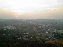
Pathanamthitta (പത്തനംതിട്ട) is a town and a municipality situated in the Central Travancore region in the state of Kerala, south India, spread over an area of 23.50 km2. It is the administrative capital of Pathanamthitta district. The town has a population of 37,538. The Hindu pilgrim centre Sabarimala is situated in the Pathanamthitta district; as the main transport hub to Sabarimala, the town is known as the 'Pilgrim Capital of Kerala'.[1] Pathanamthitta. District, the thirteenth revenue district of the State of Kerala. It was formed with effect from the 1st November, 1982 vide G.O. (M.S) No.1026/82/RD dated 29 October 1982, with headquarters at Pathanamthitta. Forest covers more than half (1396.95 km2.) of the total area of the District. Pathanamthitta District ranks the 7th in area (2652 sq. km.) in the State.
Etymology
There are different versions on how the name Pathanamthitta came about. One view is that the name is derived from two Tamil / Malayalam words Pathanam and thitta, which together mean "array of ten "family" houses by the riverside". Another opinion is that is pattanam (town) which became 'pathanam'. Thus, Pathanamthitta meant a town by the riverside.
Pathanamthitta town is located on the fertile banks of the River Achenkovil.
Sri K. K. Nair, who formed the District, is known as the Father of Pathanamthitta.
Geography
Pathanamthitta has an average elevation of 18 metres (62 ft) above sea level.[2]
The main trunk road to Sabarimala is from Pathanamthitta. The Main Eastern Highway (Punalur-Muvattupuzha Road/SH-08) and T.K.Road (Thiruvalla-Kumbazha Road/SH-07) pass through Pathanamthitta. www
Climate
| Pathanamthitta district | ||||||||||||||||||||||||||||||||||||||||||||||||||||||||||||
|---|---|---|---|---|---|---|---|---|---|---|---|---|---|---|---|---|---|---|---|---|---|---|---|---|---|---|---|---|---|---|---|---|---|---|---|---|---|---|---|---|---|---|---|---|---|---|---|---|---|---|---|---|---|---|---|---|---|---|---|---|
| Climate chart (explanation) | ||||||||||||||||||||||||||||||||||||||||||||||||||||||||||||
| ||||||||||||||||||||||||||||||||||||||||||||||||||||||||||||
| ||||||||||||||||||||||||||||||||||||||||||||||||||||||||||||
Pathanamthitta has a moderate climate, more or less the same as is prevalent elsewhere in Kerala. Annual temperatures range between 20 °C (68 °F) and 39 °C (102 °F). The district experiences three distinct weather conditions: winter, summer and the monsoon. The winter season is experienced from December to February and summer season from March to May. There are two rainy seasons: The South-West monsoon (June to September) and the North-East monsoon (October to November). The South-West monsoon is usually very heavy. About 75% of its annual rainfall is received during this season.
The town enjoys a tropical climate, the monsoons start in June.[3] The months of April–May can get pretty humid. The best weather is from October to February.
Pathanamthitta experiences three distinct seasons: summer, monsoon and winter. Typical summer months are from March to May. The warmest month in Pathanamthitta is April. Although summer doesn't end until May, the city often receives locally developed heavy thundershowers in May (although humidity remains high).
The monsoon lasts from June to August, with moderate rainfall. Most of the heavy rainfall in the city fall between June and July, and June is the wettest month of the year. Last weeks of June is also days of floods. The three major rivers viz Pampa, Achankovil and Manimala swell with rainwater.[4]
Winter begins in December. December through February are the winter months. The lowest temperatures are experienced during January.
According to the latest World Health Organisation (WHO) study on ambient air quality among 123 Indian cities, Pathanamthitta was found to have the cleanest air in India, in terms of least concentration of dust particles in air. Two out of three least polluted cities in India are from Kerala, Kollam being second least polluted. As per the database, in Pathanamthitta, the annual mean of PM10 and PM2.5 is recorded at 23 and 10 respectively, which is closer to the recommended level of concentration of particulate matter. While a number of Indian cities are among the world's most polluted, Pathanamthitta's air quality is comparable to some of the cleanest cities in North America, Europe and Australia.
| Climate data for Pathanamthitta, Kerala | |||||||||||||
|---|---|---|---|---|---|---|---|---|---|---|---|---|---|
| Month | Jan | Feb | Mar | Apr | May | Jun | Jul | Aug | Sep | Oct | Nov | Dec | Year |
| Average high °C (°F) | 31.0 (87.8) |
31.8 (89.2) |
32.9 (91.2) |
33.0 (91.4) |
32.5 (90.5) |
30.5 (86.9) |
29.8 (85.6) |
29.9 (85.8) |
30.4 (86.7) |
30.3 (86.5) |
30.0 (86) |
30.4 (86.7) |
31.04 (87.86) |
| Average low °C (°F) | 22.4 (72.3) |
23.2 (73.8) |
24.6 (76.3) |
25.5 (77.9) |
25.4 (77.7) |
24.3 (75.7) |
23.8 (74.8) |
23.8 (74.8) |
24.0 (75.2) |
23.9 (75) |
23.6 (74.5) |
22.6 (72.7) |
23.93 (75.06) |
| Average precipitation mm (inches) | 20 (0.79) |
36 (1.42) |
66 (2.6) |
160 (6.3) |
264 (10.39) |
476 (18.74) |
446 (17.56) |
306 (12.05) |
241 (9.49) |
318 (12.52) |
214 (8.43) |
57 (2.24) |
2,604 (102.53) |
| Source: Climate-Data.org[5] | |||||||||||||
Economy
Agriculture
Agriculture is the main occupation of the people. About 75% people are dependent on this sector. Rubber is the most important crop, with its plantations covering over 478 square kilometres (185 sq mi). The hilly terrain coupled with high humidity makes the region suitable for rubber plantations. Paddy is the most important crop cultivated in the wet lands. Tapioca and pulses are the important dry land crops. Other major crops are coconut, banana, pepper and ginger. In certain areas cashew, pineapple, sugarcane, cocoa and other tree spices are cultivated. The land available for cultivation is less since sizeable area of the district is reserve forest.
| Products | Area under cultivation (km2) | Production (tonne) |
|---|---|---|
| Rice | 43.39 | 10784 |
| Sugar Cane | 1.23 | 601 |
| Pepper | 56.51 | 1328 |
| Ginger | 5.26 | 1358 |
| Cardamom | 6.64 | 82 |
| Cashewnut | 11.41 | 686 |
| Rubber | 478.47 | 69094 |
| Tapioca | 79.91 | 226993 |
| Coconut | 217.39 | 380 |
- Source : Statistics for Planning-DES 2006
Fisheries
Pathanamthitta district has a unique position in the inland fisheries map of Kerala state with its freshwater resources like rivers, reservoirs, streams, ponds, quarries and paddy fields. The fisheries activities in this region started with the establishment of a Fresh Water Survey Station. The district has an Ornamental Fish Breeding resource centre and a National Fish Seed Farm. There are 2444[6] fishermen depending on this sector for their livelihood.
Pathanamthitta district has tremendous potential in fish culture sector. For the development of piscine culture activities a Fish Farmers Development Agency(F.F.D.A.) was constituted during the year 1990. The agency provide technical as well as financial assistance to the farmers. The ongoing schemes of F.F.D.A. are assistance to new pond construction, pond reclamation, supply of fish seed, feed, medicine towards input, integrated farming and establishment of mini hatcheries.
Industry
Pathanamthitta is a less industrialized district of Kerala. As of 31 March 2006, there are 13,898 registered Small Scale Industries (SSI), employing 46,421 people.[6] There are also 378 workers employed in the handloom sector. There are three Mini Industrial Estates in the district with the State government declaring 8.5 hectares of area as development plot. District Industries Centre distributes the land to needy entrepreneurs on request. 14.48 hectares of land has been transferred to KINFRA and five acres of land has been transferred to SIDCO for industrial parks. Green channel committee has been set up to help entrepreneurs get help in obtaining licenses, clearances, electricity, water connection, without delay.
Administration
Pathanamthitta assembly constituency was part of the Idukki (Lok Sabha constituency) but now Pathanamthitta is a separate Lok Sabha constituency.[7] Pathanamthitta comes under Aranmula Assembly constituency. Earlier, Pathanamthitta itself was an Assembly constituency. But after delimitation, Pathanamthitta lost its named constituency.
The district headquarters is at Pathanamthitta town. The district administration is headed by the District Collector. He is assisted by five Deputy Collectors holding charges of general matters, revenue recovery, land acquisition, land reforms and election. Under the three tier system of panchayat in rural areas, Pathanamthitta has one district panchayat, 9 block panchayat and 57 grama panthayats. Under the single tier system in urban areas, there are 4 municipalities the district. In addition, there is a census town (Kozhencherry).
As per the Delimitation of Parliamentary and Assembly Constituencies Order, 2008, Pathanamthitta has five Assembly constituencies, down from eight. However, the district was unified into a single Parliamentary constituency, thus contributing a seat to the Lok Sabha. The Pathanamthitta parliamentary constituency is formed by including all the five Assembly constituencies of the district along with two other Assembly constituencies in the neighboring Kottayam district.[8][9] Congress, Kerala Congress, BJP and the CPM/CPI are the main political parties.
Municipalities: 4
- Thiruvalla
- Pathanamthitta
- Adoor
- Pandalam
Transportation
Thiruvananthapuram International Airport (113 km), Cochin International Airport, at Nedumbassery, Kochi (142 km) are the nearest airports. Perunad Heliport (helipad) is situated in Kuttikayam estate, Mampara road. Which is known as Sabarimala helipad. Chipsan Aviation Pvt Ltd, having service from various location. Most of the Sabarimala pilgrimages are using this heliport. Tiruvalla railway station (Code: TRVL) (30 km) is the only railway station in the District. Chengannur railway station (Code: CNGR) (24 km) is the nearest Railway station. Kollam Junction Railway Station (Code: QLN) is 62 km away from Pathanamthitta. The location of Chengannur private bus stand in front of the station makes it the more convenient one. Direct Bus services to Pathanamthitta are operated from both Tiruvalla and Chengannur. The proposed Chengannur – Pandalam – Adoor – Kottarakkara – Thiruvananthapuram railway line passes through the district.
Road
Pathanamthitta is the meeting point of two major State Highways T.K. Road (SH – 07) and Main Eastern Highway (Punalur-Muvattupuzha Road / SH – 08). The city is well connected to major towns and cities inside and outside Kerala by the State run K.S.R.T.C and private buses as well as Luxury Services. Both the KSRTC and private buses play equal roles in satisfying the transportation needs of the town. The cities of Kollam, Thiruvananthapuram, Kochi, Thrissur etc. are connected by KSRTC services whereas hi-range townships like Punalur, Kumali, Pala and the Malabar Area of Northern Kerala are connected by private bus services. KSRTC is running chain services that connect Pathanamthitta with the City of Kollam via Adoor. Plenty of A/C Luxury Bus services are operated from Pathanamthitta to Bangalore, Chennai, Mangalore and Mumbai on a daily basis.
KSRTC bus stations in Pathanamthitta district are Pathanamthitta, Thiruvalla, Adoor, Pandalam, Mallapally, Ranni, and Pamba.
Distance from Pathanamthitta
- Pandalam (15 km)
- Thiruvalla (30.7 km)
- Kozhencherry (13 km)
- Sabarimala (65 km)
Culture zone
Places around Pathanamthitta city within a distance of 15 km include, Elanthoor, Ranny, Vadaserikara, Kozhencherry, Kadammanitta, Vazhamuttom, Pandalam, Manjinikara, Mathoor, Omallur, Malayalappuzha, Kodumthara, Elavumthitta-Muloor Smarakam, Kodumon, Ayroor Cherukolpuzha, Ulanadu, Kaipattoor, Mylapra, Uthimoodu, Thumpamon, Maroor, Pramadom, Konni and Valamchuzhy. The places beyond these are Thiruvalla, Nilackal, Parumala, and Maramon. Pathanamthitta lies on the road route to the pilgrim town of Sabarimala, which is 65 km away. The Chettikulangara temple, at Mavelikkara is about 35 km from Pathanamthitta. Padanilam Parabrahma Temple is situated 26 km from Pathanamthitta. Aranmula is around 14 km from Pathanamthitta. Aranmula Temple is one of the biggest temples in South India en route to Sabarimala.
- Sabarimala Mandala Pooja.[10]
- Maramon Convention was recorded in 2010 as one of the largest Christian gatherings in Asia. The annual conventions are held during the first half of February.[11]
- Cherukolpuzha Hindu matha convention[12][13]
- Aranmula annual boat race.[14]
- Aranmula Kannadi – Centuries old art of mirror making from metal composites.[15]
Notable people from Pathanamthitta District
See List of people from Pathanamthitta District
Demographics
As per Census of India 2011 Pathanamthitta had a population of 11,97,412 (11.97 Lakh) and which was lower than 12.34 lakh of previous Census of 2001. Males constitute 46.9% of the population and females 53.1%. 89% of Total population in Pathanamthitta lives in Rural area and only 11% lives in urban. Pathanamthitta District ranks the 12th place in terms of population size in the state. In total density of the District is 452 Persons per km2 which the 12th in States as per 2011 Census. In Sex-ratio, the District is in the 2nd position with 1132 females per 1,000 males. In Child Sex-ratio, the District has the 1st rank with 976 female children per 1000 male children. The District has the second position in total literacy rate (96.55 per cent) and female literacy rate (95.83 per cent). Agricultural Labourers constitute 14.1 per cent while Cultivators form 10.5 per cent of the Total Workers in the District. There are five engineering colleges and one medical college in Pathanamthitta District.
Pathanamthitta still has quite few settlements of aborigines called 'adivasis' deep in the forest area including areas like Thanithoddu, Chittar. The people from the settlements prefer not to be disturbed by the crowd from outside civilizations or lifestyles.
Religion
Pathanamthitta's major religion are Hinduism, Christianity and Islam. Sikhs, Buddhists and Jains have much smaller followings. As of 2004 the population included 694,560(56.28%) Hindus, 481,602 (39.03%) Christians and 56,457 (4.58%) Muslims, the lowest following in the State.[16] In Christian Denominations Malankara Orthodox Church, with population of 252, 352, Mar Thoma Syrian Church population of 134, 751, Jacobite and Knanaya Jacobite population accumulating to a total of 47,256 and Malankara Catholics reaching a total of 44,326.A large number of Reformation Groups also are present in this area.
Places of Worship
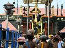
- The Sabarimala Sree Ayyappa Temple (Temple of Lord Dharmasastha), a world-famous forest pilgrim centre, is situated in the Sabarimala part of the western ghats in the Pathanamthitta district, which is hence known as the 'Pilgrim Capital of Kerala'.
- The Shivaparvathy temple Anikkattilammakshethram, *Valamchuzhi Sree Bhadrakali Devi Temple and *Vaipur Mahadeva Temple is also in the district.
- Sree Bhagavathikunnu Devi Temple, Elanthoor:[17] *One of the important and famous Goddess Abode in Thiruvitamkoor is the Bhagawati Kunnu Devi Temple, Elanthoor.
- Malayalppuzha Devi Temple, Malayalappuzha Devi Temple Malayalappuzha
- 'Parumala St. Peter's, St. Paul's and St. Gregorio's Orthodox Church (http://parumalachurch.org) famous for the tomb of Saint Gregorios or Parumala Thirumeni(Gheevarghese Mar Gregorios of Parumala).
- Makkamkunnu St. Stephen's Orthodox Cathedral (First Church in Pathanamthitta Town Region). It is Famous for Makkamkunnu Convention During three Days Lent.
- 'St. George Orthodox Church, Mylapra', also known as 'Mylapra Valiyapalli famous Georgian pilgrim centre which is 2 km away from the district headquarters. – See more at: http://www.mylapravaliyapalli.com
- Thumpamon St. Mary's Orthodox Cathedral AD 717 (Bhadrasana Devalayam).
- Chandanapally St George Orthodox church -Chandanapally Valiyapally (Feast of St George May 7 & 8 )
- Kalloopara St. Mary's Orthodox church(Lent from 1 to 15th Aug is very Famous)
- Paliekara St. George Orthodox church
- Ponnambi Palli (Pilgrim Church Near Malayalapuzha).
- Pathanamthitta Town Juma Masjid
Flora and Fauna

Pathanamthitta has tropical biodiversity with forest, plantations, rivers and fertile land. Fifty percent of the district is covered with forest, providing rich flora and fauna. The district has a variety of plants including medicinal, spices, tuber crops and those yielding fruits and fiber. Aromatic plants and spices such as pepper, ginger, cardamom and turmeric are cultivated on a large scale. Trees such as timber, teak, rosewood, jack tree, manjakadambu, anjili, pala can be found in abundance.
The forests of the district have excellent wild life habitats. A variety of animals and birds can be found. Tigers, elephants, gaur, deer, monkeys and other wild animals are found in the forest. Giant squirrel, lion-tailed macaques, barking deer and bear can also be spotted in the reserve. Malabar grey hornbill and great Indian hornbill are found. Wide variety of other birds such as sunbirds, woodpeckers and kingfishers can also be seen.
The existence of the wildlife habitat is under threat from various areas. Pollution from fertilizer and industries and illegal sand mining are the major threats. Issues connected to Sabarimala pilgrimage such as clearing of forest land and large amount of waste discharged also threatens the habitat.[18][19]
Educational Institutions
- College of Applied Science, Pathanamthitta
- College of Applied Sciences (I.H.R.D), Adoor
- B.A.M. College, Pamba
- Catholicate College, Pathanamthitta
- Devaswom Board College, Parumala
- Marthoma College, Pathanamthitta
- N.S.S. College, Pandalam
- Sahodaran Ayyappan Smaraka. *(S.N.D.P) Yogam College, Konni
- St. Cyrils College, Pathanamthitta
- St. Thomas College, Thuruthicaud
- Mannam Ayurved Medical College, pandalam
- Caarmel Engineering College, Perunad
- College of Engineering, Kallooppara
- College of Engineering, Pathananthitta
- Mount Zion College of Engineering, Pathanmthitta
- Musliar College of Engineering and Technology, Kumbazha
- Sree Buddha College of Engineering for Women Pathanamthitta
- Pushpagiri Institute of Medical Sciences and Research Centre, Pathanamthitta
- College of Nursing, Pathanamthitta
- Archana College of Nursing, Pandalam
- M.G.M. Muthoot College of Nursing, Kallarakadavu, Pathanamthitta
- Pushpagiri College of Nursing, Pathanamthitta
- K.V.V.S. Institute of Technology, Adoor
- Mar Athanasios College for Advanced Studies, Tiruvalla
- Mar Athanasius College of Advanced Studies, Pathanamthitta
- St. John's College Thorrupram, Pathanamthitta
Sports
The Aranmula Boat Race is part of a festival celebrated during the month of September. Though the snake boat race is also performed at nearby places, the race held at Aranmula is unique because of the boats' shape and design. Maramadimatsaram (Ox Race) is another such seasonal sport. This is held as part of the largest annual cattle fair of Central Travancore region. The race is held in three categories.[20]
While football is the most popular sport, cricket is the most-followed sport as in the rest of the state and India. The Public stadium at Tiruvalla houses some of the important sports activities (mainly cricket) in the district.
Notes
- ↑ http://www.keralatravels.com/resourcepage.php?sid=14&rid=281 KeralaTravels
- ↑ "FallingRain Map". Fallingrain.com. Retrieved 2013-03-21.
- ↑ http://www.mustseeindia.com/Pathanamthitta-weather
- ↑ http://www.pathanamthitta.com/physiography.htm
- ↑ "CLIMATE: PATHANAMTHITTA", Climate-Data.org. Web: .
- 1 2 "District level database of Pathanamthitta" (PDF). Government of Kerala. 2006. Archived from the original (PDF) on 22 November 2008. Retrieved 2009-08-25.
- ↑ "Assembly Constituencies – Corresponding Districts and Parliamentary Constituencies" (PDF). Kerala. Election Commission of India. Archived from the original (PDF) on March 4, 2009. Retrieved 2008-10-20.
- ↑ "Parliamentary Constituencies of Kerala - 2008". Government of Kerala. Retrieved 2009-08-27.
- ↑ Radhakrishnan Kuttoor (2008-01-31). "Due recognition for the youngest district". The Hindu. Retrieved 2009-08-27.
- ↑ "Mandala Pooja/ Makaravilakku". Sabarimala.kerala.gov.in. Retrieved 2013-03-21.
- ↑ "pathanamthittainfo.com". pathanamthittainfo.com. Retrieved 2013-03-21.
- ↑ "About it". Hmmp.org. Retrieved 2013-03-21.
- ↑ "Festivals of India-Aranmula-Vallamkali (Boat Race )". Festivalsofindia.in. 2010-06-15. Retrieved 2013-03-21.
- ↑ "Festivals of India- Aranmula Boat race". Festivalsofindia.in. 2010-06-15. Retrieved 2013-03-21.
- ↑ "The Making of Aranmula kannadi". Youtube.com. 2010-01-04. Retrieved 2013-03-21.
- ↑ Govind, Biju (2004-09-23). "Increase in Muslim population in the State". The Hindu. Retrieved 2009-09-15.
- ↑ http://www.elanthoordevi.org
- ↑ "Pampa pollution". Pampa Parirakshana Samithy, N.G.O. Retrieved 2009-08-27.
- ↑ "TDB to get forest land at Nilackal today". The Hindu. 2005-06-16. Retrieved 2009-08-27.
- ↑ "Maramadimatsaram". Department of tourism, Kerala. Retrieved 2009-08-27.
References
External links
| Wikimedia Commons has media related to Pathanamthitta. |