Esna
| Esna إسنا | |
|---|---|
|
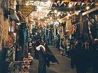
Esna Tourist bazaar at night | |
 Esna Location in Egypt | |
| Coordinates: 25°18′N 32°33′E / 25.300°N 32.550°E | |
| Country |
|
| Governorate | Luxor |
| Time zone | EST (UTC+2) |
Esna (Egyptian Arabic: إسنا IPA: [ˈʔesnæ]), known to the ancient Egyptians as Egyptian: Iunyt or Ta-senet; Coptic (Sahidic): ⲥⲛⲏ (Sne), which derives from Ta-senet;[1] Greek: Λατόπολις (Latopolis or Letopolis)[2] or πόλις Λάτων (Polis Laton)[3] or Λάττων (Latton);[4][5] Latin: Lato, is a city in Egypt. It is located on the west bank of the River Nile, some 55 km south of Luxor. The town was formerly part of the modern Qena Governorate, but as of 9/12/2009, has been incorporated into the new Luxor Governorate.
Latopolis
This city of Latopolis (πόλις Λάτων) in the Thebaid region of Upper Egypt should not be confused with the more northerly city of Letopolis (Λητοῦς Πόλις), ancient Khem, modern Ausim, in the Nile Delta in Lower Egypt.[6][7][8]
The ancient city
The name "Latopolis" is in honor of the Nile perch, Lates niloticus, the largest of the 52 species which inhabit the Nile,[9] which was abundant in these stretches of the river in ancient times, and which appears in sculptures, among the symbols of the goddess Neith, associated by the ancient Greeks as Pallas-Athene, surrounded by the oval shield or ring indicative of royalty or divinity.[10] Held sacred, the Lates niloticus was buried in a cemetery west of the town.
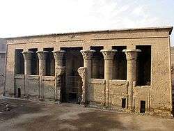
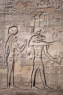
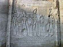
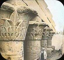
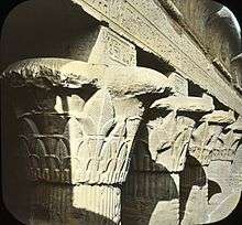
The tutelary deities of Latopolis seem to have been the triad – Khnum and Neith, and Heka their offspring. The temple of Esna, dedicated to this triad, was remarkable for the beauty of its site and the magnificence of its architecture. It was built of red sandstone, and its portico consisted of six rows of four columns each, with lotus-leaf capitals, all of which however differ from each other.[11]
Another temple of the same period has been identified at Kom Mer, about 12 km to the south, but cannot be excavated because a modern village is built over it.
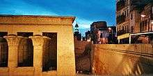
There was a smaller temple, dedicated to the triad of Latopolis, about two miles and a half north of the city, at a village now called el-Dayr. Here, too, is a small Zodiac of the age of Ptolemy III Euergetes (246-221 BC). This latter building was destroyed in the 19th century, as it stood in the way of a new canal. The temple of Esna was cleared of the soil and rubbish which filled its area when Denon visited it, and served as a cotton warehouse in the mid-19th century.[12]
With the exception of the jamb of a gateway – now converted into a door-sill – of the reign of Thutmose II (Eighteenth Dynasty), the remains of Latopolis belong to the Ptolemaic or Roman eras. Ptolemy III Euergetes, the restorer of so many temples in Upper Egypt, was a benefactor to Latopolis, and he is depicted upon the walls of its temple followed by a tame lion, and in the act of striking down the chiefs of his enemies. The name of Ptolemy V Epiphanes is found also inscribed upon a doorway. Although the scale of the ruins are impressive, their sculptures and hieroglyphics attest to the decline of Egyptian art. The west wall features reliefs of Ptolemy VI Philometor and Ptolemy VIII Physcon. The pronaos, which alone exists, resembles in style that of Apollonopolis Magna (Edfu), and was begun not earlier than the reign of Claudius (41-54 AD), and completed in that of Vespasian, whose name and titles are carved on the dedicatory inscription over the entrance. On the ceiling of the pronaos is the larger Latopolitan Zodiac. The name of the emperor Geta, the last ruler that can be read in hieroglyphics, although partially erased by his brother and murderer Caracalla (212), is still legible on the walls of Latopolis. Before raising their own edifice, the Romans seem to have destroyed even the basements of the earlier Egyptian temple. The ceremonial way, which probably linked the quay to the temple, has disappeared. The quay bears cartouches of Marcus Aurelius.
The cemetery west of the town, where the Lates niloticus was buried, also contains human burials dating of the Middle Kingdom to the Late Period.
Ritual Significance
The Temple of Esna conveys a sense of the importance which the Ancient Egyptians placed upon their places of worship. All Egyptians who entered the confines of an Egyptian temple were required "to comply with the strict rules regarding ritual purity."[13] According to inscriptions carved on the walls of the Temple of Esna, those who entered this temple were expected to fastidiously cut their fingernails and toenails, remove other body hair, wash their hands with natron (a natural occurring salt), "be dressed in linen (they were forbidden from wearing wool), and not to have had sexual intercourse for several days."[14]
Modern Esna
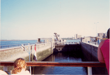
Two barrage bridges straddle the Nile at this point: one built by the British in 1906, and the "Electricity Bridge" built in the 1990s. Navigation, particularly, Nile cruisers ferrying tourists from Luxor to Aswan 155 km further upstream, can be held up for hours while vessels negotiate their way through the lock system.
The two main points of interest in Esna are its lively tourist-oriented market, which fills a couple of streets leading inland from the corniche. The other is the temple of Esna. The temple, which has only been partially excavated, is about 200 meters from the river and some 9 meters below street level.
Former bishopric
Under the older name of "Latopolis," the city is now a Roman Catholic Latin titular see.
Climate
Köppen-Geiger climate classification system classifies its climate as hot desert climate (BWh).
| Climate data for Esna | |||||||||||||
|---|---|---|---|---|---|---|---|---|---|---|---|---|---|
| Month | Jan | Feb | Mar | Apr | May | Jun | Jul | Aug | Sep | Oct | Nov | Dec | Year |
| Average high °C (°F) | 23.4 (74.1) |
25.5 (77.9) |
29.5 (85.1) |
34.8 (94.6) |
39.2 (102.6) |
40.8 (105.4) |
40.9 (105.6) |
41 (106) |
38.4 (101.1) |
35.7 (96.3) |
30.3 (86.5) |
25.2 (77.4) |
33.73 (92.72) |
| Daily mean °C (°F) | 14.9 (58.8) |
16.5 (61.7) |
20.2 (68.4) |
25.3 (77.5) |
29.9 (85.8) |
31.6 (88.9) |
32.1 (89.8) |
32.3 (90.1) |
30 (86) |
27.1 (80.8) |
21.6 (70.9) |
16.7 (62.1) |
24.85 (76.73) |
| Average low °C (°F) | 6.4 (43.5) |
7.5 (45.5) |
11 (52) |
15.9 (60.6) |
20.6 (69.1) |
22.5 (72.5) |
23.4 (74.1) |
23.6 (74.5) |
21.6 (70.9) |
18.6 (65.5) |
12.9 (55.2) |
8.3 (46.9) |
16.03 (60.86) |
| Average precipitation mm (inches) | 0 (0) |
0 (0) |
0 (0) |
0 (0) |
0 (0) |
0 (0) |
0 (0) |
0 (0) |
0 (0) |
0 (0) |
0 (0) |
0 (0) |
0 (0) |
| Source: Climate-Data.org[15] | |||||||||||||
Notes
- ↑ Werner Vycichl, Dictionnaire étymologique de la langue copte (Louvain, 1983)
- ↑ Strabo xvii. pp. 812, 817
- ↑ Ptol. iv. 5. § 71
- ↑ Hierocl. p. 732
- ↑ Itin. Antonin. p. 160
- ↑ Trismegistos Geo, Letopolis
- ↑ Egypt: Minor Temple and Other Ruins of the Nile Delta, Part I
- ↑ Margaret Bunson, Encyclopaedia of Ancient Egypt (Infobase Publishing 2009 ISBN 978-1-43810997-8), p. 60
- ↑ Russegger, Reisen, vol. I. p.300
- ↑ Wilkinson, M. and C. vol. V. p.253
- ↑ Dominique-Vivant Denon, Voyage dans la Basse et lau Haute Égypte, vol. I. (1818), p.148.
- ↑ Karl Richard Lepsius, Nubische Grammatik mit einer Einleitung über die Völker und Sprachen Afrika's. Berlin: Verlag von Wilhelm Hertz (1880), p.63
- ↑ Lucia Gahlin, Egypt: Gods, Myths and Religion, Anness Publishing Litd (Lorenz Books) 2001. p.106
- ↑ Gahlin, p.106
- ↑ "Climate: Isna - Climate graph, Temperature graph, Climate table". Climate-Data.org. Retrieved 18 August 2013.
References
 This article incorporates text from a publication now in the public domain: Smith, William, ed. (1854–1857). "article name needed". Dictionary of Greek and Roman Geography. London: John Murray.
External links
| Wikimedia Commons has media related to Esna. |
- biologie.uni-hamburg.de, Gallery of temple reliefs
- Falling Rain Genomics, Inc. Geographical information on Esna
- (German) Esna on Wikivoyage
- fotopedia.com, Selected photos of Esna
- Esna revisited, Al-ahram Weekly historical review on Esna by Giovanna Montalbetti with photos by Sherif Sonbol
Coordinates: 25°18′N 32°33′E / 25.300°N 32.550°E