Espinho Branco
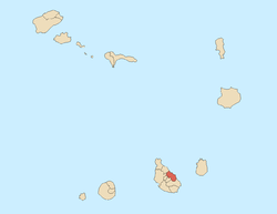
Espinho Branco is a village in the northern part of the island of Santiago, Cape Verde. Its 2010 population was 869. It is situated in the mountains, about 5 km east of the summit of the Serra da Malagueta inside its ranges and 5 km northwest of Calheta de São Miguel. The place name etymology is hawthorn, dominant in the area. The built up area stretches for about a kilometer.
West of the village is Ribeira Brava and nearly a kilometer northeast is the source of the tiny Ribeira Calhau.
Agriculture dominates the area, the groves dominates a part of the area.
Espinho Branco has the largest Rabelados community on the island, it is a community that were isolated from the rest of society, the name is a Cape Verdean creole name for "Rebelados" or "Revoltados" which means rebels.
Nho Agostinho (d. 2006) was once an inhabitant of Espinho Branco, leader of the Rabelados community.
In 2007, the Cape Verdean prime minister visited the Rabelados community in Espinho Branco on February 9, 2007[2]
References
|
|---|
|
| Communities and settlements | | |
|---|
|
| Mountain | |
|---|
|
| Stream | |
|---|
|
| Culture | |
|---|
|
|