Tarrafal, Cape Verde (municipality)
| Tarrafal | |
|---|---|
| Municipality | |
 | |
| Coordinates: 15°16′N 23°43′W / 15.26°N 23.71°WCoordinates: 15°16′N 23°43′W / 15.26°N 23.71°W | |
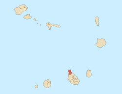
| Country | Cape Verde |
| Island | Santiago |
| Area | |
| • Total | 120.8 km2 (46.6 sq mi) |
| Population (2010)[1] | |
| • Total | 18,561 |
| • Density | 150/km2 (400/sq mi) |
Tarrafal is a concelho (municipality) of Cape Verde. It is situated in the northern part of the island of Santiago. Its seat is the town Tarrafal. Its population was 18,561 at the 2010 census.[1]
Under Salazar the Tarrafal Concentration Camp was built on the plain south of town (Chão Bom) to contain opponents of the political regime.
Subdivisions
The municipality consists of one freguesia (civil parish), Santo Amaro Abade. The freguesia is subdivided into the following settlements, its population data are of the 2010 census:
- Achada Biscanhos (pop: 310)
- Achada Lagoa (pop: 64)
- Achada Longueira (pop: 520)
- Achada Meio (pop: 211)
- Achada Moirão (pop: 587)
- Achada Tenda (pop: 1,242)
- Biscainhos (pop: 695)
- Chão Bom (pop: 5,166)
- Curral Velho (pop: 358)
- Fazenda (pop: 107)
- Figueira Muita (pop: 160)
- Lagoa (pop: 55)
- Mato Brazil (pop: 160)
- Mato Mendes (pop: 194)
- Milho Branco (pop: 165)
- Ponta Lobrão (pop: 435)
- Ribeira da Prata (pop: 1,009)
- Tarrafal (pop: 6,656)
- Trás os Montes (pop: 464)
Economy
The economy includes businesses, agriculture, fishing, and tourism.
History
The municipality was created on May 4, 1912, when two northern parishes of the older Municipality of Santa Catarina were split off to become the Municipality of Tarrafal, the seat of Santa Catarina moved to Assomada and Tarrafal became the seat of a municipality with its own name. In 1991, a southeastern parish of the Municipality was split off to become the Municipality of São Miguel.
Sights
Tarrafal has various sights to offer. There are an interesting town hall, a market hall, a comparatively large church, Saint Amaro Abade and Estádio de Mangue in the southern end next to the communal boundary with Chão Bom and newly constructed hotels east of it, in the market place. Every year Tarrafal invites everyone to celebrate the name festival (Festa de Santo Amaro). The date is January 15.
Other sites includes two lighthouses in the northwestern and northern extremities of the island including Ponta Preta locate on the point with the same name and another at Ponta Moreia.
Sports
Several football (soccer) clubs are founded in the municipality, all clubs play at Estádio de Mangue in the Mangue neighborhood in the south of Tarrafal north of the communal limits.
- Barcelona
- Beira-Mar, the oldest club in Tarrafal
- Chão Bom or Tchon Bon (also as Txon Bon)
- Estrela dos Amadores
- Real Júnior
- Varandinha
Demography
Most of the population is rural. The urban population is concentrated in the town of Tarrafal.
| Population of Tarrafal, Cape Verde (municipality) (1940—2010) | |||||||
|---|---|---|---|---|---|---|---|
| 1940[2][3] | 1950[2][3] | 1960[2][3] | 1970[2][3] | 1980[2][3] | 1990[2] | 2000[4] | 2010[1] |
| 18840 | 13222 | 19140 | 26251 | 24202 | 11626 | 17792 | 18561 |
Politics
The MpD is the ruling party of the municipality which won 43.7% in the last election.
Municipal assembly
| 2004 % | 2004 seats | 2008 % | 2008 seats | 2012 % | 2012 seats | |
|---|---|---|---|---|---|---|
| Movement for Democracy | 68.82 | 12 | 66 | - | 53 | 9 |
| PAICV | 21.27 | 4 | 28.8 | - | 43.7 | 8 |
| PCD-PRD | 9.9 | 0 | - | - | - | - |
Municipality
| 2004 % | 2004 seats | 2008 % | 2008 seats | 2012 % | 2012 seats | |
|---|---|---|---|---|---|---|
| Movement for Democracy | 70.14 | 7 | 67.8 | - | 52.8 | 7 |
| PAICV | 22.06 | 0 | 28.8 | - | 44.2 | 0 |
| PCD-PRD | 7.8 | 0 | - | - | - | - |
Notable people
- Anilton César Varela da Silva, futsal player
- Gracelino Barbosa, para-athlete
- Pedro Celestino SIlva Soares, footballer (soccer player)
- Silvino Lopes Évora, writer
- Mário Lúcio de Sousa, singer, member of the band Simentera
- Janício Martins, footballer (soccer player)
Gallery
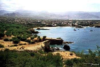 General view of the town and the bay
.jpg) Beach of Tarrafal
Beach of Tarrafal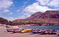 Beach
Beach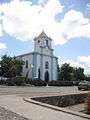 Saint Amaro Abade Church
 Town Hall
 Market Hall
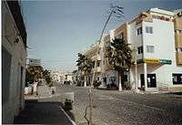 Main Street
External links
- Câmara Municipal do Tarrafal
- ANMCV (Associação Nacional dos Municípios Cabo-Verdianos - National Association of the Capeverdean Municipalities)
References
| Wikimedia Commons has media related to Tarrafal. |
Subdivisions of the island of Santiago | |||||||
|---|---|---|---|---|---|---|---|
| Praia |
|  | |||||
| Ribeira Grande de Santiago |
| ||||||
| Santa Catarina |
| ||||||
| Santa Cruz |
| ||||||
| São Domingos | |||||||
| São Lourenço dos Órgãos |
| ||||||
| São Miguel |
| ||||||
| São Salvador do Mundo |
| ||||||
| Tarrafal |
| ||||||
| Communities and settlements | | |
|---|---|---|
| Geographical features | ||
| Landmarks and points of Interests |
| |
| Culture |
| |