Fairview Township, Caldwell County, Missouri
| Fairview Township | |
|---|---|
| Township | |
 | |
| Coordinates: 39°39′45″N 093°48′13″W / 39.66250°N 93.80361°WCoordinates: 39°39′45″N 093°48′13″W / 39.66250°N 93.80361°W | |
| Country | United States |
| State | Missouri |
| County | Caldwell |
| Area | |
| • Total | 35.88 sq mi (92.93 km2) |
| • Land | 35.86 sq mi (92.88 km2) |
| • Water | 0.02 sq mi (0.05 km2) 0.05% |
| Elevation[1] | 886 ft (270 m) |
| Population (2000) | |
| • Total | 161 |
| • Density | 4.5/sq mi (1.7/km2) |
| FIPS code | 29-23464[2] |
| GNIS feature ID | 0766360 |
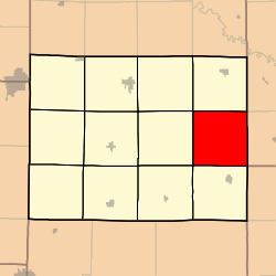
Fairview Township is one of twelve townships in Caldwell County, Missouri, USA. As of the 2000 census, its population was 161.
Fairview Township was established in 1869, and named after a school of the same name within its borders.[3]
Geography
Fairview Township covers an area of 35.88 square miles (92.9 km2) and contains no incorporated settlements.
The streams of Dead Oak Branch, Flat Creek, Panther Creek and Turkey Creek run through this township.
References
- ↑ "US Board on Geographic Names". United States Geological Survey. 2007-10-25. Retrieved 2008-01-31.
- ↑ "American FactFinder". United States Census Bureau. Retrieved 2008-01-31.
- ↑ "Caldwell County Place Names, 1928–1945 (archived)". The State Historical Society of Missouri. Retrieved 7 September 2016.
External links
Municipalities and communities of Caldwell County, Missouri, United States | ||
|---|---|---|
| Cities | 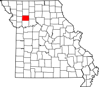 | |
| Townships | ||
| Unincorporated communities | ||
| Ghost town | ||
This article is issued from Wikipedia - version of the 9/27/2016. The text is available under the Creative Commons Attribution/Share Alike but additional terms may apply for the media files.