Fall River (Wyoming, Idaho)
| Fall River | |
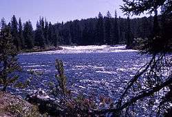 Fall River, Yellowstone National Park, 1964 | |
| Country | United States |
|---|---|
| States | Wyoming, Idaho |
| Counties | Teton County, Wyoming, Fremont County, Idaho |
| Source | |
| - location | southwest of Lewis Lake, Teton County, Wyoming |
| - elevation | 8,872 ft (2,704 m) [1] |
| - coordinates | 44°14′51″N 110°45′43″W / 44.24750°N 110.76194°W [2] |
| Mouth | Henrys Fork |
| - location | northeast of St. Anthony, Fremont County, Idaho |
| - elevation | 5,046 ft (1,538 m) [2] |
| - coordinates | 44°01′07″N 111°34′52″W / 44.01861°N 111.58111°WCoordinates: 44°01′07″N 111°34′52″W / 44.01861°N 111.58111°W [2] |
| Length | 64 mi (103 km) [3] |
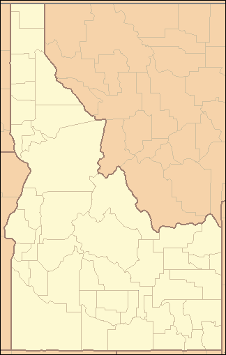 Location of the mouth of the Fall River in Idaho | |
Fall River rises on the Madison and Pitchstone plateaus in the southwest corner of Yellowstone National Park, Wyoming and flows approximately 64 miles (103 km)[3] to its confluence with the Henrys Fork of the Snake River near Ashton, Idaho. Historically, the river was referred to as the Middle Fork of the Snake River[4] or as Fall River or the Falls River by trappers and prospectors as early as the 1830s.[5] It was officially named the Falls River by the 1872 Hayden Geological Survey, but was always called Fall River by the locals[6] and so the U.S. Board on Geographic Names changed the official name to Fall River in 1997 at the request of Idaho authorities.[2] The river is home to numerous waterfalls and cascades in its upper reaches.
Waterfalls
The Fall River is located in the remote "Cascade Corner" of the park, a name given to the southwest section of the park by then-superintendent Horace Albright in 1921 for the proliferation of waterfalls and cascades in the Fall and Bechler River drainages. Several major Yellowstone waterfalls exist in the Fall River watershed:[7]
- Cave Falls, 20 feet (6.1 m),44°08′41″N 110°59′50″W / 44.14472°N 110.99722°W[8]
- Terraced Falls, 130 feet (40 m), 44°08′50″N 110°51′51″W / 44.14722°N 110.86417°W[9]
Angling
Although the Fall River is in the remote Cascade Corner of the park, it is popular with local anglers. It holds mostly cutthroat trout and a few rainbow trout and brook trout. Because of spring runoff, the river is generally not fishable until mid-July and access is difficult.[10][11] Within the park, the upper section of the river is accessible via the Grassy Lake Road, which starts near the south entrance to the park, while the lower sections are accessible via the Cave Falls Road in Idaho. Once the Fall River leaves the park it is accessible in a variety of locations via Idaho county roads.
See also
Notes
- ↑ Source elevation derived from Google Earth search using GNIS source coordinates.
- 1 2 3 4 "Fall River". Geographic Names Information System. United States Geological Survey. December 31, 1992. Retrieved July 23, 2013.
- 1 2 "National Hydrography Dataset". United States Geological Survey. Retrieved July 23, 2013.
- ↑ Richard (Beaver Dick) Liegh refers to Fall River as the Middle Fork in his journals. See Beaver Dick, The Honor and The Heartbreak by Thompson and Tompson, Jelm Mountain Press, 1981, ISBN 0-936204-26-5
- ↑ Whittlesey, Lee (1996). Yellowstone Place Names. Gardiner, MT: Wonderland Publishing Company. p. 103. ISBN 1-59971-716-6.
- ↑ The local power company that was founded in the 1930s was named Fall River Electric
- ↑ Whittlesey, Lee (1996). Yellowstone Place Names. Gardiner, MT: Wonderland Publishing Company. pp. 61–62. ISBN 1-59971-716-6.
- ↑ "Cave Falls". Geographic Names Information System. United States Geological Survey.
- ↑ "Terraced Falls". Geographic Names Information System. United States Geological Survey.
- ↑ Parks, Richard (1998). Fishing Yellowstone National Park. Helena, MT: Falcon Press. ISBN 1-56044-625-0.
- ↑ Mathews, Craig; Molinero, Clayton (1997). The Yellowstone Fly-Fishing Guide—An authoritative guide to the waters of Yellowstone National Park. Guilford, CT: The Lyons Press. ISBN 1-55821-545-X.
Yellowstone National Park - Cascade Corner | ||
|---|---|---|
Rivers, Waterfalls, Peaks and Lakes in the Cascade Corner (Southwest) section of the park | ||
| Rivers |  | |
| Waterfalls and Cascades | ||
| Lakes and Peaks | ||
| ||