Fara Novarese
| Fara Novarese | |
|---|---|
| Comune | |
| Comune di Fara Novarese | |
|
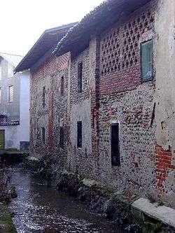
Canal at Via Cavour in Fara Novarese | |
 Fara Novarese Location of Fara Novarese in Italy | |
| Coordinates: 45°33′N 8°28′E / 45.550°N 8.467°ECoordinates: 45°33′N 8°28′E / 45.550°N 8.467°E | |
| Country | Italy |
| Region | Piedmont |
| Province / Metropolitan city | Province of Novara (NO) |
| Area | |
| • Total | 9.4 km2 (3.6 sq mi) |
| Population (Dec. 2004) | |
| • Total | 2,085 |
| • Density | 220/km2 (570/sq mi) |
| Demonym(s) | Faresi |
| Time zone | CET (UTC+1) |
| • Summer (DST) | CEST (UTC+2) |
| Postal code | 28073 |
| Dialing code | 0321 |
| Website | Official website |
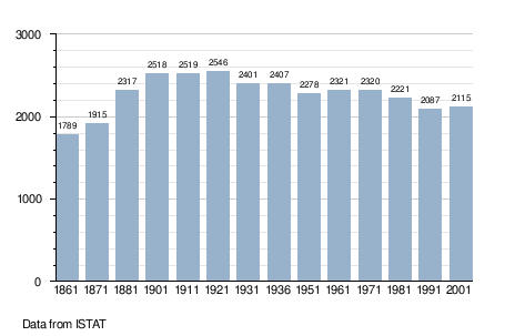
Fara Novarese is a comune (municipality) in the Province of Novara in the Italian region Piedmont, located about 80 kilometres (50 mi) northeast of Turin and about 15 kilometres (9 mi) northwest of Novara. As of 31 December 2004, it had a population of 2,085 and an area of 9.4 square kilometres (3.6 sq mi).[1]
Fara Novarese borders the following municipalities: Barengo, Briona, Carpignano Sesia, Cavaglio d'Agogna, and Sizzano.
Fara DOC
The commune of Fara is home to the Denominazione di origine controllata (DOC) wine which includes 22 hectares (54 acres) producing a single red wine. The wine is a blend of 30 to 50 percent Nebbiolo, 10 to 30 percent Vespolina and up to 40 percent of Uva Rara (known locally as Bonarda Novarese). All grapes destined for DOC wine production need to be harvested to a yield no greater than 11 tonnes/ha. The finished wine must attain a minimum alcohol level of 12 percent in order to be labelled with the Fara DOC designation.[2]
Demographic evolution
References
- ↑ All demographics and other statistics: Italian statistical institute Istat.
- ↑ P. Saunders Wine Label Language pg 160 Firefly Books 2004 ISBN 1-55297-720-X