Fertőszentmiklós
| Fertőszentmiklós | ||
|---|---|---|
| ||
 Fertőszentmiklós Location of Fertőszentmiklós | ||
| Coordinates: 47°35′07″N 16°52′14″E / 47.58533°N 16.87052°ECoordinates: 47°35′07″N 16°52′14″E / 47.58533°N 16.87052°E | ||
| Country |
| |
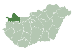
| County | Győr-Moson-Sopron | |
| Area | ||
| • Total | 39.39 km2 (15.21 sq mi) | |
| Population (2009) | ||
| • Total | 3,802 | |
| • Density | 98.62/km2 (255.4/sq mi) | |
| Time zone | CET (UTC+1) | |
| • Summer (DST) | CEST (UTC+2) | |
| Postal code | 9444 | |
| Area code(s) | 99 | |
Fertőszentmiklós is a small town in Győr-Moson-Sopron county, Hungary.
Location
Fertőszentmiklós is located on the Small Plain and it is part of the Transdanubian region. It has a population of 3873 people. Fertőszentmiklós is very well situated because it’s close to the Hungarian-Austrian border. The name of the town comes from the fusion of two smaller villages: Szentmiklós and Szerdahely. So they called the new village Fertőszentmiklós.
Twin towns — Sister cities
Fertőszentmiklós is twinned with:
-
 Pleidelsheim, Germany (1994)
 -
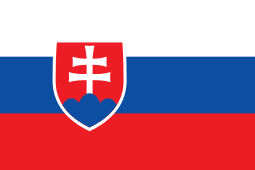 Leopoldov, Slovakia (2003)
External links
- Street map (Hungarian)
This article is issued from Wikipedia - version of the 7/20/2014. The text is available under the Creative Commons Attribution/Share Alike but additional terms may apply for the media files.