Fishers Hill, Virginia
| Fishers Hill, Virginia | |
|---|---|
| Unincorporated community | |
 Fishers Hill  Fishers Hill | |
| Coordinates: 38°59′10″N 78°23′53″W / 38.98611°N 78.39806°WCoordinates: 38°59′10″N 78°23′53″W / 38.98611°N 78.39806°W | |
| Country | United States |
| State | Virginia |
| County | Shenandoah |
| Elevation | 689 ft (210 m) |
| Time zone | Eastern (EST) (UTC-5) |
| • Summer (DST) | EDT (UTC-4) |
| ZIP code | 22626 |
| Area code(s) | 540 |
| GNIS feature ID | 1483426[1] |
Fishers Hill is an unincorporated community in Shenandoah County, Virginia, United States. Fishers Hill is 2.1 miles (3.4 km) west of Strasburg. Fishers Hill has a post office with ZIP code 22626, which opened on July 28, 1882.[2][3]
The Snapp House was listed on the National Register of Historic Places in 1979.[4]
References
- ↑ "Fishers Hill". Geographic Names Information System. United States Geological Survey.
- ↑ United States Postal Service (2012). "USPS - Look Up a ZIP Code". Retrieved 2012-02-15.
- ↑ "Postmaster Finder - Post Offices by ZIP Code". United States Postal Service. Retrieved December 27, 2012.
- ↑ National Park Service (2010-07-09). "National Register Information System". National Register of Historic Places. National Park Service.
Municipalities and communities of Shenandoah County, Virginia, United States | ||
|---|---|---|
| Towns | 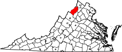 | |
| CDPs | ||
| Unincorporated communities | ||
This article is issued from Wikipedia - version of the 7/27/2016. The text is available under the Creative Commons Attribution/Share Alike but additional terms may apply for the media files.