Fitzroy River (Queensland)
| Fitzroy (Toonooba) | |
| River | |
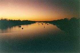 Dawn breaks on the Fitzroy River as it passes through Rockhampton | |
| Name origin: In honour of Sir Charles FitzRoy[1] | |
| Country | Australia |
|---|---|
| State | Queensland |
| Region | Central Queensland |
| City | Rockhampton |
| Source confluence | Dawson River and Mackenzie River |
| - coordinates | 23°37′39″S 149°46′1″E / 23.62750°S 149.76694°E |
| Mouth | Coral Sea |
| - location | near Port Alma |
| - elevation | 0 m (0 ft) |
| - coordinates | 23°32′15″S 150°53′13″E / 23.53750°S 150.88694°ECoordinates: 23°32′15″S 150°53′13″E / 23.53750°S 150.88694°E |
| Length | 480 km (298 mi) |
| Basin | 142,665 km2 (55,083 sq mi) |
| Discharge | |
| - average | 187 m3/s (6,604 cu ft/s) |
| National park | Goodedulla National Park |
| Reservoirs | Eden Bann Weir; Fitzroy River Barrage |
| Islands | Egg Island; Mudd Island; Mackenzie Island |
 Location of Fitzroy River mouth in Queensland | |
| Wikimedia Commons: Fitzroy River, Queensland | |
| [2] | |
The Fitzroy River (Darumbal: Toonooba[1]) is a river located in Central Queensland, Australia. Its catchment covers an area of 142,665 square kilometres (55,083 sq mi), making it the largest river catchment flowing to the eastern coast of Australia.[3]
Course and features
Formed by the confluence of the Mackenzie and Dawson rivers that drain the Expedition Range and the Carnarvon Range respectively, the Fitzroy River rises at Duaringa[4] and flows initially north by east, then northward near the Goodedulla National Park. The river then flows in an easterly direction near the Lake Learmouth State Forest and parallel with the Bruce Highway through the settlement of Yamba, before turning south to Rockhampton where the river is crossed by the Bruce Highway. After flowing through Rockhampton, the river flows south by east past the Beserker Range past Humbug Point to the south of the Flat Top Range and eventually discharging into Keppel Bay in the Coral Sea near the MacKenzie Island Conservation Park.[2]
From source to mouth, the Fitzroy River is joined by thirty-six tributaries including the Mackenzie River – with its tributaries the Nogoa River, Comet River, Isaac River and its tributary Connors River; and the Dawson River – which has two tributaries, the Don River and Dee River.[2][5]
Catchment
The catchment area of the river occupies an area of 142,665 square kilometres (55,083 sq mi)[3] Within the drainage basin an area of 292 square kilometres (113 sq mi) is composed of estuarine wetlands and an area of 1,548 square kilometres (598 sq mi) is made up of riverine wetlands.[6] The catchment stretches from the Carnarvon Range in the west to the rivermouth in Keppel Bay, near Rockhampton. It is bounded to the north by the Burdekin River catchment area and to the south by the Burnett River catchment area.[3]
The river has a mean annual discharge of 5,900 gigalitres (7.717×10⁹ cu yd). There are also a number important aquifers providing for groundwater extractions in the Fitzroy Basin.[7]
The Fitzroy River basin is one of a number that experienced extensive flooding during the 2010–2011 Queensland floods. In 2013, flash flooding in the Mount Morgan and Biloela regions brought major flooding to the lower Dawson River catchment. The Don River and the Dee River also rose to new record heights. The Fitzroy River at Rockhampton rose above major flooding to 8.61 metres (28.2 ft).
Reservoirs
The Fitzroy River catchment system has many weirs and dams, used for farming, mining and domestic consumption. In the Dawson River sub-catchment, the major reservoirs from source to mouth are the Glebe Weir, the Gyranda Weir, the Theodore Weir, the Moura Weir, the Callide Dam, and the Kroombit Dam. In the Mackenzie River sub-catchment, the major reservoirs are the Comet Weir, the Fairbairn Dam, the Theresa Creek Dam, the Bedford Weir, the Bingegang Weir, and the Tartrus Weir. In the main Fitzroy River sub-catchment the only reservoirs are the Eden Bann Weir and the Fitzroy River Barrage, with the latter capable of holding 61,000 megalitres (1.3×10¹⁰ imp gal; 1.6×10¹⁰ US gal) when full,[4] to provide potable water to Rockhampton city and surrounds.
The Fairbairn Dam on the Nogoa River and several weirs downstream on the Mackenzie River provide water for irrigating a wide range of crops including cotton, peanuts, chickpea, corn and horticulture including citrus, table grapes, melons, supplying water for coal mines and domestic use for the town of Emerald.
History
The traditional owners of the area in the Fitzroy River catchment are the Darumbal people, notably the Baiali[8] and Jetimarala clans.[9]
The river was named by European colonial settlers and pastoralists, Charles and William Archer, on 4 May 1853 in honour of Sir Charles FitzRoy, at the time the Governor of the Colony of New South Wales,[1] as Queensland did not become a separate colony until 1859.
The city of Rockhampton is situated on the river, some 40 kilometres (25 mi) from the coast. During the 19th and early 20th centuries, the city was a major port, however rocky bars in the river prevented the Fitzroy from being used for navigation any further inland. As ships became larger, the lower reaches became less viable for commercial traffic, and today only pleasure craft and small commercial fishing boats use the river.[10] Wharves which once lined the town reach at Rockhampton have now almost all disintegrated or been removed. Predominant industries in the catchment are coal mining, grazing and cotton.
Glenmore Homestead was built at a property on the northern bank of the river 7 kilometres (4.3 mi) northwest of Rockhampton. It was originally settled in 1858, is listed on the Queensland Heritage Register and operates as a tourist attraction today.[11]
Wildlife
The lower reaches of the river are home to salt water crocodiles. In 2003 a crocodile measuring more than 4 metres (13 ft) long was captured. The most diverse range of freshwater fish in the country are found within the Fitzroy basin.[4] The prized Australian fish, the barramundi, breeds in the river along with sooty grunter and a separate genetic strain of golden perch.[4]
Some 987 square kilometres (381 sq mi) of the river's floodplain and delta have been classified by BirdLife International as the Fitzroy Floodplain and Delta Important Bird Area (IBA). It regularly supports over 1% of the world population of the sharp-tailed sandpiper as well as having a resident breeding population of the range-restricted mangrove honeyeater.[12]
At the mouth of the river researchers have discovered a genetically distinct snubfin dolphins species with a population of just 70 animals. The World Wildlife Fund believes planned coal port on Balaclava Island by Xstrata could wipe out the local snubfin population.[13]
Gallery
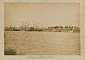 Shipping on the Fitzroy River, Rockhampton wharves, ca. 1887.
 Rockhampton in flood.
 Rockhampton in flood, 2013.
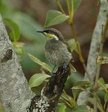 The lower reaches of the river are an important site for mangrove honeyeaters.
See also
References
- 1 2 3 "Fitzroy River (entry 12565)". Queensland Place Names. Queensland Government. Retrieved 18 November 2015.
- 1 2 3 "Map of Fitzroy River, QLD". Bonzle Digital Atlas of Australia. Retrieved 18 November 2015.
- 1 2 3 Fitzroy Basin Association (2005). Central Queensland Strategy for Sustainability: 2004 and beyond. Rockhampton, Qld.: The Fitzroy Basin Association Inc. ISBN 0-9758172-0-5.
- 1 2 3 4 Harrison, Rod; James, Ernie; Sully, Chris; Classon, Bill; Eckermann, Joy (2008). Queensland Dams. Bayswater, Victoria: Australian Fishing Network. p. 157. ISBN 978-1-86513-134-4.
- ↑ "Fitzroy Basin Resource Operations Plan" (PDF). Department of Natural Resources and Water. Brisbane: Queensland Government. September 2015.
- ↑ "Fitzroy drainage basin". Wetlandinfo. Queensland Government. Retrieved 25 June 2015.
- ↑ "Fitzroy Basin Draft Resource Operations Plan - Overview Report" (PDF). Queensland Government. October 2013. Retrieved 25 June 2015.
- ↑ "Baiali". AusAnthrop Australian Aboriginal tribal database. Ausanthrop. Retrieved 25 June 2015.
- ↑ "Jetimarala". AusAnthrop Australian Aboriginal tribal database. Ausanthrop. Retrieved 25 June 2015.
- ↑ McDonald L. (1981). Rockhampton: A History of City and District. St Lucia, Qld.: University of Queensland Press. ISBN 0-7022-1620-8.
- ↑ "Glenmore Homestead (entry 600823)". Queensland Heritage Register. Queensland Heritage Council. Retrieved 13 July 2015.
- ↑ "IBA: Fitzroy Floodplain and Delta". Birdata. Birds Australia. Archived from the original on 6 July 2011. Retrieved 20 June 2011.
- ↑ "Coal port could wipe out dolphin pod: WWF". The Sydney Morning Herald. Fairfax Media. 14 October 2011. Retrieved 9 November 2011.
External links
| Wikimedia Commons has media related to Fitzroy River, Queensland. |
- Map of the Fitzroy River catchment area, from Australia's Bureau of Meteorology
- Fitzroy Basin water planning area (PDF) (Map). Department of Natural Resources and Mines, Queensland Government. 11 September 2015.
- "Fitzroy Basin". Fitzroy Basin Association.
- "Helping protect Queensland's largest catchment". Fitzroy River and Coastal Catchments Inc.
Rivers of Queensland | |||||||||||||||||||||||||
|---|---|---|---|---|---|---|---|---|---|---|---|---|---|---|---|---|---|---|---|---|---|---|---|---|---|
| |||||||||||||||||||||||||
| |||||||||||||||||||||||||
| |||||||||||||||||||||||||
| |||||||||||||||||||||||||
| |||||||||||||||||||||||||
| |||||||||||||||||||||||||