Flintshire (historic)
| Flintshire Welsh: Sir y Fflint | |
|---|---|
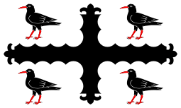 Flag adopted in 2015 | |
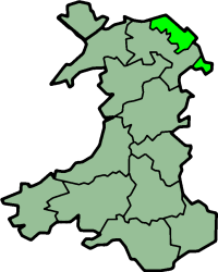 Ancient extent of Flintshire | |
| Area | |
| • 1831 | 184,905 acres (748.28 km2) |
| Population | |
| • 1831 | 60,012[1] |
| Density | |
| • 1831 | 0.32 |
| History | |
| • Created | 1284 |
| Status |
Ceremonial county (until 1974) Administrative county (1889–1974) |
| Chapman code | FLN |
| Government |
Flintshire County Council (1889–1974) |
| • HQ | Flint |
Flintshire (Welsh: Sir y Fflint), also known as the County of Flint, is one of Wales' thirteen historic counties, and a former administrative county (and a vice-county). It mostly lies on the north-east coast of Wales.
Flintshire is notable as having one of the few large county exclaves (an area known as "English Maelor" or "Maelor Saesneg") to survive the Counties (Detached Parts) Act 1844.
The administrative county of Flint was abolished under the Local Government Act 1972 on 1 April 1974, becoming part of the new county of Clwyd. The exclaves became part of Wrexham Maelor district – other parts formed the districts of Alyn and Deeside, Delyn and Rhuddlan. A unitary authority, also named Flintshire, was formed in 1996 under the Local Government (Wales) Act 1994, consisting only of the Alyn and Deeside and Delyn districts – the Wrexham Maelor parts now form part of Wrexham County Borough, with the former Rhuddlan district forming the northernmost part of the current Denbighshire unitary authority.
Geography
The historic county does not have the same boundaries as the current administrative Flintshire; in particular it includes a large exclave called Maelor Saesneg; it also includes Prestatyn, Rhyl and St Asaph which are now administered as part of Denbighshire, as well as Bangor-on-Dee and Overton-on-Dee, which are administered as part of Wrexham. Other exclaves of the historic Flintshire include the manors of Marford and Hoseley, Abenbury Fechan and Bryn Estyn, all on the outskirts of Wrexham, and also a small part of the parish of Erbistock around the Boat Inn. These are all completely surrounded by the historic county of Denbighshire. Additionally, a small part of Flintshire, including the village of Sealand, is isolated across the River Dee when its course was changed to improve navigation.
The county was formed in 1284 following the defeat of the Principality of Wales under the terms of the Statute of Rhuddlan by combining Cantrefi that were formerly parts of Gwynedd Is Conwy and Powys Fadog:
It also included the Lordships of Mold, Hawarden, Mostyn and Hope.
Flintshire is a maritime county bounded to the north by the Irish Sea, to the north-east by the Dee estuary, to the east by Cheshire and to the south and southwest by Denbighshire. The Maelor Saesneg is bounded on the north-west by Denbighshire, on the north-east by Cheshire, and on the south by Shropshire.
Flintshire is the smallest historic county in Wales. The coast along the Dee estuary is heavily developed by industry and the north coast much developed for tourism. The Clwydian Mountains occupy much of the west of the county. The highest point is Moel Famau (1,820 feet / 554 metres). The chief towns are Buckley, Connah's Quay, Flint, Hawarden, Holywell, Mold, Queensferry, and Shotton. The main rivers are the Dee (the estuary of which forms much of the coast) and the Clwyd. The main industries are manufacturing of aircraft components (Airbus), engines (Toyota), paper (Shotton Paper), steel processing (Corus), agriculture and tourism.
Places of special interest include castles in Flint, Hawarden, Rhuddlan and Ewloe, and Wepre Country Park, Connah's Quay.
See also
- Flintshire
- List of Lord Lieutenants of Flintshire
- List of Custodes Rotulorum of Flintshire
- List of High Sheriffs of Flintshire
- Flintshire (UK Parliament constituency)
References
- ↑ Vision of Britain – 1831 Census

Coordinates: 53°15′N 3°10′W / 53.250°N 3.167°W