Nant-y-Ffrith

Nant-y-Ffrith refers to a stream and the wooded valley through which it flows on the border between Flintshire and Wrexham County Borough in Wales. The stream begins in moorland to the east of Llandegla. It passes Bwlchgwyn village before entering a rather steep-sided, rocky valley. It passes under the viaduct of a disused railway line before joining the River Cegidog at Ffrith.
The woodlands contain some deciduous trees but are dominated by recent conifer plantations. They contain a range of flora and fauna including various ferns and mosses and woodland birds such as wood warbler and redstart.
There are several abandoned silica quarries and lead mines in the area. Lead mining may have begun as early as Roman times and has left a number of caves.
Nant-y-Ffrith Hall
Nant-y-Ffrith Hall was originally built as a hunting lodge in 1850. Successive owners enlarged the building and created landscaped gardens. An open day and garden party was held each year for local villagers. The hall gradually fell into disrepair; it was used for ammunition storage in the Second World War and finally demolished between 1947 and 1950. The only signs of it today are a clearing in the woods, scattered stones and some exotic vegetation such as rhododendrons.
Nant-y-Ffrith Waterfall
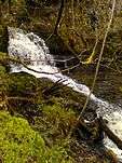
Roughly halfway down the gorge, approximately 100m upstream of a small wooden footbridge that crosses the stream, there is a large three-tier waterfall hidden amongst the trees. The waterfall is the largest in the Flintshire / Wrexham area, the nearest other sizable waterfall being Dyserth falls in Denbighshire.


Despite the waterfall's size and significance, access is poor and public information is very limited. Access to the bottom of the falls is from a small path on the south side of the valley accessed about 20m upstream from the wooden footbridge. Access to the top of the falls is from a bend in the forestry track next to a sign warning of steep and dangerous ground. Both paths are steep, uneven and slippery.
During the heyday of Nant-y-Ffrith Hall in the second half of the 19th century steps were built up the rocks on the north side of the falls allowing viewing and access to all parts of the falls. Unfortunately, like the hall, the gardens and these steps fell into disrepair and they are no longer present.
Nant-y-Ffrith Reservoir
| Nant-y-Ffrith Reservoir | |
|---|---|
| Location | Wales |
| Coordinates | 53°4′11″N 3°7′52″W / 53.06972°N 3.13111°W |
| Type | reservoir |
| Primary inflows | Nant-y-Ffrith |
| Primary outflows | Nant-y-Ffrith |
| Basin countries | United Kingdom |
This is a small reservoir near the source of the stream. It provides water to the villages to the west of Wrexham. Work began on it in October 1868 and it was supplying water by February 1871. It was built by Brymbo Water Company and is now owned by Dee Valley Water.
Breeding birds on the reservoir include great crested grebe and coot with sedge warbler and reed bunting in the surrounding vegetation and lapwing and curlew in nearby fields.
References
- Clwyd Bird Recording Group (various years) Clwyd Bird Report.
- R. J. Jones (1957) Maes Maelor, Gwasg John Penry, Swansea.
- Raymond Lowe (2002) Lost Houses in and around Wrexham, Landmark Publishing, Ashbourne.
