Four Corners Monument
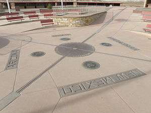 Four Corners Monument, after its 2010 reconstruction | |
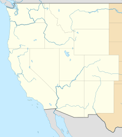 The monument's location in the western United States | |
| Coordinates | 36°59′56″N 109°02′43″W / 36.998976°N 109.045172°W |
|---|---|
| Location | The quadripoint in the Southwestern United States where the states of Arizona, Colorado, New Mexico, and Utah meet |
| Designer | The Navajo Nation and the U.S. Department of the Interior |
| Type | Megalithic |
| Material | Granite and brass |
| Beginning date | 1868 |
| Completion date | 1912 |
| Opening date | 1931 |
| "Here meet, in freedom, under God, four states." | |
The Four Corners Monument marks the quadripoint in the Southwestern United States where the states of Arizona, Colorado, New Mexico, and Utah meet. It is the only point in the United States shared by four states, leading to this area's being called the Four Corners region.[1] The monument also marks the boundary between two semi-autonomous Native American governments, the Navajo Nation, which maintains the monument as a tourist attraction, and the Ute Mountain Ute Tribe Reservation.
The origins of the state boundaries marked by the monument occurred just prior to, and during, the American Civil War, when the United States Congress acted to form governments in the area to combat the spread of slavery to the region. When the early territories were formed, their boundaries were designated along meridian and parallel lines. Beginning in the 1860s, these lines were surveyed and marked. These early surveys included some errors, but even so, the markers placed became the legal boundaries, superseding the written descriptions of geographical meridians and parallels. This includes the Four Corners Monument, which has been legally established as the corner of the four states.
Monument
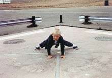
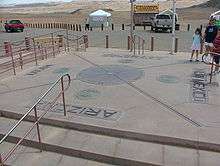
The monument where "visitors can simultaneously straddle the territory of four states" is maintained as a tourist attraction by the Navajo Nation Parks and Recreation Department. Unlike many other attractions based on what are primarily political boundaries, such as the Berlin Wall, Four Corners Monument is an example of a political boundary that is a tourist destination in its own right.[2] The monument consists of a granite disk embedded with a smaller bronze disk around the point, surrounded by smaller, appropriately located state seals and flags representing both the states and tribal nations of the area. Circling the point, starting from north, the disk reads with two words in each state "Here meet in freedom under God four states".[3] Around the monument, local Navajo and Ute artisans sell souvenirs and food. An admission fee is required to view and photograph the monument.[4] The monument is a popular tourist attraction despite its remote and isolated location. As early as 1908, people traveled long distances to take pictures of family and friends at the monument in Twister-like poses, sitting on the disk, in a circle of friends or family around the disk, or for couples to kiss directly over the disk.[5]
Location
The monument is located on the Colorado Plateau west of U.S. Highway 160, approximately 40 miles (64 km) southwest of Cortez, Colorado. The monument is centered at 36°59′56.31″N 109°02′42.62″W / 36.9989750°N 109.0451722°W.[6] In addition to the four states, two semi-autonomous American Indian tribal governments have boundaries at the monument, the Navajo Nation and the Ute Mountain Ute Tribe Reservation, with the Ute Mountain tribal boundaries coinciding with Colorado's boundaries at the monument.[7]
Climate
The nearby community of Teec Nos Pos receives 8.46 inches of rain and 2 inches of snow annually.[8]
| Climate data for Teec Nos Pos | |||||||||||||
|---|---|---|---|---|---|---|---|---|---|---|---|---|---|
| Month | Jan | Feb | Mar | Apr | May | Jun | Jul | Aug | Sep | Oct | Nov | Dec | Year |
| Average high °F (°C) | 43 (6) |
50 (10) |
60 (16) |
69 (21) |
78 (26) |
89 (32) |
94 (34) |
90 (32) |
83 (28) |
70 (21) |
55 (13) |
44 (7) |
68.8 (20.4) |
| Average low °F (°C) | 22 (−6) |
27 (−3) |
33 (1) |
40 (4) |
50 (10) |
59 (15) |
65 (18) |
63 (17) |
54 (12) |
42 (6) |
31 (−1) |
22 (−6) |
42.3 (5.7) |
| Source: U.S. Climate Data[9] | |||||||||||||
History
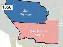

The area now called Four Corners was initially American Indian land and beginning in the 16th century it was claimed by Spain as part of New Spain. After Mexico gained independence from Spain in 1821, the area was governed by Mexico until being ceded to the United States by the Treaty of Guadalupe Hidalgo in 1848 following the United States' victory in the Mexican–American War.[10] The first boundary which would become part of the monument was set as part of the Compromise of 1850, which created the New Mexico Territory and Utah Territory. The border between the two territories was congressionally defined as the 37th parallel north by the 31st United States Congress. In 1861, the 36th United States Congress transferred land previously allocated to the Utah Territory, to the newly created Colorado Territory. The Colorado Territory's southern border would remain as the 37th parallel north, but a new border—between the Colorado and Utah Territories—was declared to be the 32nd meridian west from Washington. This line was derived from the reference used at the time, the Washington meridian.[11]
In 1860, just prior to the outbreak of the American Civil War, a group of people in the southern portion of New Mexico Territory passed a resolution condemning the United States for creating such a vast territory with only a single, small government in place at Santa Fe. They claimed by doing so the U.S. had ignored the needs of the southern portion, left them without a functional system of law and order, and allowed the situation to deteriorate into a state of chaos and near anarchy.[12] The group declared secession from the United States and announced their intent to join the Confederate States of America under the name of the Arizona Territory. The U.S. Congress responded in 1863 by creating another Arizona Territory with different, but partially overlapping boundaries. The Confederate boundaries split New Mexico along an east–west line, the 34th parallel north, allowing for a single state connection from Texas to the Colorado River. This would give the Confederacy access to California and the Pacific coast. The Union definition split New Mexico along a north–south line, the 32nd meridian west from Washington, which simply extended the boundary between Colorado and Utah southward. The Union plan eventually became reality, and this created the quadripoint at the modern Four Corners.[13] After the split, New Mexico resembled its modern form, with only slight differences.[14]
Surveying the boundaries
After the Civil War, efforts began to survey and mark the actual borders. In 1868, the General Land Office (GLO) had Ehud N. Darling survey and set markers along the border between the Colorado and New Mexico Territories (the 37th parallel north); this border has become known as the "Darling Line".[15] In 1875, another GLO surveyor, Chandler Robbins, surveyed and marked the border between the Arizona and New Mexico Territories (the 32nd meridian west of Washington). Robbins began near the Mexico–United States border, and worked his way north marking the border every so often. Near the 37th parallel north he intersected the Darling Line, and here he erected a sandstone shaft. This sandstone shaft marked today's location of the Four Corners Monument.[16][17]
In 1878, Rollin J. Reeves surveyed and marked the border between the newly created State of Colorado and the Utah Territory. Reeves located the sandstone shaft marker placed by Robbins at today's Four Corners Monument. He then began to survey and mark the border between Colorado and Utah from this point northward. In 1901, Howard B. Carpenter surveyed and marked the border between Arizona and Utah, completing the survey of borders making up the Four Corners Monument.[17]
The results of these surveys and the markers placed were later accepted as the legal boundaries between the various states.[18]
The marker's transformation into a monument
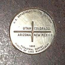
By 1899, the sandstone shaft marker placed by Chandler Robbins in 1875 had been disturbed and broken, so it was replaced with a new stone by two U.S. Surveyors, Hubert D. Page and James M. Lentz. In 1912, a simple cement pad was poured around the marker. The first modern Navajo government convened in 1923 in an effort to organize and regulate an increasing amount of oil exploration activities on Navajo lands, and they would play a big role in the monument's further development.[4][19] In 1931, Everett H. Kimmell, another U.S. Surveyor, found this newer stone had broken too and he replaced it with a brass disc marker set in cement. In 1962, the Bureau of Land Management and the Bureau of Indian Affairs poured an elevated cement pad around the 1931 brass marker; this pad included the state border lines and names in tile. The monument was completely rebuilt in 1992, and the 1931 brass marker was replaced with a disc shaped aluminum-bronze plate set in granite. The monument was again rebuilt in 2010, although the disc shaped plate from 1992 remained in place. [17][20][21]
Misplacement controversy
Since the early 20th century, controversies have arisen regarding the accuracy of the monument's placement.[22][23] After the initial surveys, it was found that the borders did not always follow the lines of meridian and parallel (as they had been intended to) due to the primitive surveying technology available at the time of construction. This discrepancy left the four states asking if the correct borders were the exact lines of meridian and parallel (and if new, more accurate, surveys needed to be done), or if the markers placed during the initial surveys were now the actual border. The issue was resolved when New Mexico sued Colorado in 1919, and in 1925 the Supreme Court ruled that the markers placed during the initial surveys were the actual borders, even if the markers were off in some locations (this includes the Four Corners Monument).[24] Today's legal description of these border lines are based on the original markers, and not the written description of the borders created when the territories were formed. Because of this, the borders between these states are not perfectly straight and often zigzag. One example is the border between Colorado and Utah, where in one area the border jogs west about 1.5 miles (2.4 km) from where it was intended to be placed. Because this error occurred in the original survey—which superseded the written description (being simply the 32nd meridian west of Washington), the border set out by the markers remains the border between the two states.[25] (38°16′34″N 109°03′38″W / 38.27619°N 109.06065°W)
In 2009 this issue was again brought to the forefront due to American media reports that the monument was placed 2.5 miles (4.0 km) west of its intended location. These reports were quickly corrected after it was discovered that sources had forgotten that when the initial surveys were conducted that the Washington meridian was used. This meridian has an offset from the modern reference, the Prime Meridian, which has been used in the United States since 1912. This offset is often missed by those not familiar with the history of American surveying.[26]
Even after the mistakes in the reports were discovered, a spokesperson for the U.S. National Geodetic Survey admitted the monument is placed 1,807 feet (551 m) east of where modern surveyors would mark the point. However, he defended the accuracy of the original survey, stating surveyors "nailed it" considering the primitive tools of the day. Pointing out the achievement given the conditions, he further stated, "Their ability to replicate that exact point — what they did was phenomenal, what they did was spot on." He concluded by stating that any claims of errors in the location of the monument are irrelevant. Once a survey commissioned to establish a boundary has been accepted by the involved parties, the survey markers are legally binding, regardless of any error that is later discovered.[18] Similar statements were issued by the Navajo Nation, defending their work in maintaining and promoting the monument.[16] In addition, general U.S. land principles,[27] law,[28] and the Supreme Court have established that the location of the monument is the legal corner of the four states.[24]
See also
- 37th parallel north – Congressionally defined border running east–west through the monument
- 32nd meridian west from Washington – Congressionally defined border running north–south through the monument
- New Mexico State Road 597 – Highway used to access the monument
Similar places
References
- ↑ "Explore Four Corners". Canyonlands eSolutions. Retrieved 2009-03-10.
- ↑ Timothy, Dallen J. (Spring 2000). "BORDERLANDS: An Unlikely Tourist Destination?" (PDF). Boundary and Security Bulletin. IBRU. 8 (1): 57–65. Retrieved 2009-05-11.
- ↑ Arizona Highways (Volume 39), Raymond Carlson (Editor), George M. Avey (Editor), Arizona Highways Department, First Annual Bound Edition, 1963, 440 pages
- ↑ Draper, Electa (2006-09-03). "A corner on the market –"Corner" office with a 4-state view". Denver Post. Retrieved 2009-05-09.
- ↑ "Four Corners" (text file). NGS Survey Monument Data Sheet. United States National Geodetic Survey. 2003-05-07.
- ↑ "Ute Mountain Ute Indian Reservation" (PDF). U.S. Department of Energy. Retrieved 2008-05-11.
- ↑ "Climate Teec Nos Pos - Arizona". Retrieved May 27, 2015.
- ↑ "Climate Teec Nos Pos - Arizona". Retrieved May 27, 2015.
- ↑ "Treaty of Guadalupe Hidalgo (1848)". U.S. National Archives and Records Administration. Retrieved 2009-05-09.
- ↑ "An Act to provide a temporary Government for the Territory of Colorado" (PDF). Thirty-sixth United States Congress. 1861-02-28. Retrieved 2007-01-15.
- ↑ "History of Las Cruces:Confederate Territory of Arizona". City of Las Cruces, New Mexico. Archived from the original on February 15, 2011. Retrieved 2009-05-09.
- ↑ Rodgers, R.L. (1900-09-05). "Two Arizona Territories.; One Organized by the Confederate States in 1862, the Other a Year Later by the United States". New York Times (republished from the Atlanta Constitution). p. 11.
- ↑ Thompson, Mark (2007-10-22). "The New Mexico Constitution meets the facts on the ground" (PDF). Bar Bulletin. New Mexico State Bar Association. Retrieved 2009-05-09.
- ↑ Stimpson, George (1946). A Book About A Thousand Things. Harper & Brothers. ISBN 0-7607-3803-3.
- 1 2 3 "Field Notes of the Remonumentation of the Corner Common to the State of Colorado, New Mexico, Arizona and Utah" (PDF). Bureau of Land Management. 1992. Retrieved 2013-06-09.
- 1 2 White, Elizebeth (2009-04-22). "Marker was off, but Four Corners monument legit". Associated Press.
- ↑ "Utah History Resource Center – Monuments and Markers Database". State of Utah. Retrieved 2009-05-09.
- ↑ Johnson, Kirk (2010-07-29). "Tourists Discover You Can't Get There From Here". New York Times. Retrieved 2010-08-04.
- ↑ Arave, Lynn (2009-04-19). "Four Corners marker 2½ miles off? Too late". Deseret News. Retrieved 2009-04-20.
- ↑ "Correction: Four Corners marker story". Associated Press. 2009-04-22.
- 1 2 "New Mexico V. Colorado, 267 U. S. 30". U.S. Supreme Court. 1925. Retrieved 2009-04-20.
- ↑ Case, William F. (2000). "Kink in Utah's border". Utah Geological Survey: Survey Notes. Utah Geological Survey. Retrieved 2013-06-09.
- ↑ Roeder, Fred (2009-04-21). "The Washington Meridian". American Surveyor Magazine. Retrieved 2009-04-22.
- ↑ "The Boundary lines, actually run and marked in the surveys returned by the surveyor general, shall be established as the proper boundary lines of the sections or subdivisions for which they were intended", Manual of Instructions for the Survey of The Public Lands of the United States. Commissioner of the General Land Office. 1919. ISBN 0-16-003588-0. Retrieved 2009-04-20.
- ↑ (Title U.S.C. 43, Sec, 752)."U.S. Code". United States Congress. Retrieved 2009-04-20.
External links
| Wikimedia Commons has media related to Four Corners Monument. |
| Wikivoyage has a travel guide for Four Corners. |
- Official site – Navajo Parks and Recreation
- NGS Survey Information
- Geocaching Recovery Logs
Coordinates: 36°59′56″N 109°02′43″W / 36.998976478°N 109.045172275°W