Vaalserberg
| Vaalserberg | |
|---|---|
 The Vaalserberg seen from Aachen | |
| Highest point | |
| Elevation |
322.7 m (1,059 ft) |
| Coordinates | 50°45′17″N 6°01′15″E / 50.75472°N 6.02083°ECoordinates: 50°45′17″N 6°01′15″E / 50.75472°N 6.02083°E |
| Naming | |
| Translation | Mount Vaals (English) |
| Geography | |
 Vaalserberg Netherlands | |
| Location | Limburg, Netherlands |
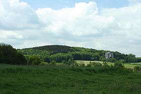
The Vaalserberg is a hill with a height of 322.7 metres (1,059 ft) above NAP and the highest point in mainland Netherlands. The Vaalserberg is located in the province of Limburg, at the south-easternmost edge of the country, near the town of Vaals (for which it is named).
After the Dutch possessions in the Caribbean were incorporated into the Kingdom of the Netherlands, the Vaalserberg was replaced as the Netherlands' highest mountain by Mount Scenery.
Three-Country Point
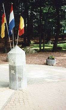
Dreiländerpunkt
The Vaalserberg is also the location of the tripoint between Germany, Belgium and the Netherlands, and its summit is therefore called the Drielandenpunt ("three country point") in Dutch, or Dreiländereck ("three country corner") in German, or Trois Frontières ("three borders") in French.
On the Belgian side, the tripoint borders the region of Wallonia, including both the regular French-speaking area and the very small German-speaking area. Between 1830 and 1919, the summit was a quadripoint, also bordering Neutral Moresnet - today part of Belgium's German speaking areas.
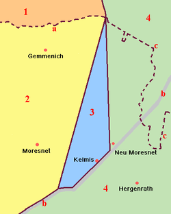
Legend:
The current Belgian-German-border is not the same as the former eastern border of Moresnet with Prussia; it lies a little more to the east. Therefore, five different borders came together at this point, however never more than four at one time - except possibly for the period 1917-1920, when the border situation was unclear and disputed.
This border intersection has made the Vaalserberg a well-known tourist attraction in the Netherlands with a tower on the Belgian side (Dutch: Boudewijntoren; French: Tour Baudouin) offering a grand panorama of the surrounding landscape.
Four-borders road
The road leading up to this point on the Dutch side is called the Viergrenzenweg ("four borders way"), probably because of the territory of Moresnet. The names of the roads in Belgium (Route des Trois Bornes) and Germany (Dreiländerweg) only refer to three.[1]
Road cycling
The Vaalserberg is often used in the Amstel Gold Race and is climbed halfway through the race. The climb is named in the roadbook of the Gold Race as Drielandenpunt and is followed by the Gemmenich climb.
See also
References
| Wikimedia Commons has media related to Border triangle Vaalserberg. |