Fredonia, Arizona
| Fredonia, Arizona | |
|---|---|
| Town | |
 | |
 Location in Coconino County and the state of Arizona | |
 Fredonia, Arizona Location in the United States | |
| Coordinates: 36°56′58″N 112°31′18″W / 36.94944°N 112.52167°WCoordinates: 36°56′58″N 112°31′18″W / 36.94944°N 112.52167°W | |
| Country | United States |
| State | Arizona |
| County | Coconino |
| Area | |
| • Total | 7.4 sq mi (19.2 km2) |
| • Land | 7.4 sq mi (19.2 km2) |
| • Water | 0.0 sq mi (0.0 km2) |
| Elevation | 4,671 ft (1,424 m) |
| Population (2010)[1] | |
| • Total | 1,314 |
| • Estimate (2014)[2] | 1,317 |
| • Density | 180/sq mi (68/km2) |
| Time zone | MST (UTC-7) |
| ZIP codes | 86022, 86052 |
| Area code | 928 |
| FIPS code | 04-25720 |
| Website | Town of Fredonia |
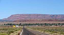
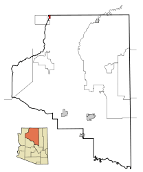
Fredonia is a town in Coconino County, Arizona, United States. As of the 2010 census it had a population of 1,314.[1] Fredonia is Arizona's northernmost town and the gateway to the North Rim of the Grand Canyon.
History
The Anasazi or Basket Makers were the first inhabitants in the area. Their presence is marked by ancient ruins in the cliffs throughout Arizona.
Fredonia was originally started in 1885 as a business venture by five men who invested time, money, and energy to build a dam so they could create farmland under irrigation.
Geography and climate
Fredonia is located at 36°56′58″N 112°31′18″W / 36.94944°N 112.52167°W (36.949522, -112.521700),[3] at 4,680 feet (1,430 m) in elevation. It is in the Arizona Strip, the portion of Arizona lying north of the Colorado River, and is within a few miles of the Utah border. According to the United States Census Bureau, the town has a total area of 7.4 square miles (19 km2), all of it land.
Fredonia is also located within a short distance of other national parks, national monuments, state parks, and scenic outdoor recreation spots.
| Climate data for Fredonia, Arizona | |||||||||||||
|---|---|---|---|---|---|---|---|---|---|---|---|---|---|
| Month | Jan | Feb | Mar | Apr | May | Jun | Jul | Aug | Sep | Oct | Nov | Dec | Year |
| Record high °F (°C) | 78 (26) |
72 (22) |
83 (28) |
86 (30) |
96 (36) |
107 (42) |
110 (43) |
104 (40) |
99 (37) |
96 (36) |
78 (26) |
70 (21) |
110 (43) |
| Average high °F (°C) | 46.2 (7.9) |
51.6 (10.9) |
59.7 (15.4) |
68.5 (20.3) |
77.4 (25.2) |
87.3 (30.7) |
93.7 (34.3) |
90.7 (32.6) |
84.2 (29) |
72.2 (22.3) |
58.5 (14.7) |
47.9 (8.8) |
69.8 (21) |
| Average low °F (°C) | 19.5 (−6.9) |
22.1 (−5.5) |
26.0 (−3.3) |
31.9 (−0.1) |
38.5 (3.6) |
46.6 (8.1) |
55.4 (13) |
54.2 (12.3) |
45.4 (7.4) |
35.4 (1.9) |
26.1 (−3.3) |
20.1 (−6.6) |
35.1 (1.7) |
| Record low °F (°C) | −20 (−29) |
−15 (−26) |
−2 (−19) |
2 (−17) |
18 (−8) |
26 (−3) |
34 (1) |
33 (1) |
26 (−3) |
9 (−13) |
0 (−18) |
−18 (−28) |
−20 (−29) |
| Average precipitation inches (mm) | 1.13 (28.7) |
0.80 (20.3) |
0.88 (22.4) |
0.62 (15.7) |
0.48 (12.2) |
0.29 (7.4) |
0.73 (18.5) |
1.21 (30.7) |
0.89 (22.6) |
0.90 (22.9) |
0.77 (19.6) |
0.97 (24.6) |
9.67 (245.6) |
| Average snowfall inches (cm) | 7.0 (17.8) |
3.5 (8.9) |
3.5 (8.9) |
1.1 (2.8) |
0 (0) |
0 (0) |
0 (0) |
0 (0) |
0 (0) |
0.2 (0.5) |
1.3 (3.3) |
4.8 (12.2) |
21.4 (54.4) |
| Average precipitation days (≥ 0.01 in) | 5 | 4 | 4 | 3 | 3 | 2 | 4 | 5 | 3 | 4 | 3 | 4 | 44 |
| Source: Western Regional Climate Center[4] | |||||||||||||
Demographics
| Historical population | |||
|---|---|---|---|
| Census | Pop. | %± | |
| 1960 | 643 | — | |
| 1970 | 798 | 24.1% | |
| 1980 | 1,040 | 30.3% | |
| 1990 | 1,207 | 16.1% | |
| 2000 | 1,036 | −14.2% | |
| 2010 | 1,314 | 26.8% | |
| Est. 2015 | 1,322 | [5] | 0.6% |
| U.S. decennial census[6] 2014 estimate[2] | |||
As of the census[7] of 2000, there were 1,036 people, 359 households, and 287 families residing in the town. The population density was 139.7 people per square mile (54.0/km²). There were 455 housing units at an average density of 61.4 per square mile (23.7/km²). The racial makeup of the town was 85.71% White, 1.06% Black or African American, 11.39% Native American, 0.39% from other races, and 1.45% from two or more races. 1.45% of the population were Hispanic or Latino of any race.
There were 359 households out of which 37.9% had children under the age of 18 living with them, 65.5% were married couples living together, 10.0% had a female householder with no husband present, and 19.8% were non-families. 15.9% of all households were made up of individuals and 5.3% had someone living alone who was 65 years of age or older. The average household size was 2.89 and the average family size was 3.25.
In the town the age distribution of the population shows 32.3% under the age of 18, 6.2% from 18 to 24, 27.7% from 25 to 44, 22.7% from 45 to 64, and 11.1% who were 65 years of age or older. The median age was 35 years. For every 100 females there were 104.3 males. For every 100 females age 18 and over, there were 98.0 males.
The median income for a household in the town was $30,288, and the median income for a family was $30,913. Males had a median income of $24,904 versus $19,554 for females. The per capita income for the town was $13,309. About 12.3% of families and 15.0% of the population were below the poverty line, including 25.4% of those under age 18 and 3.2% of those age 65 or over.
Education
Fredonia is a part of the Fredonia-Moccasin Unified School District. Two schools, Fredonia Elementary/Middle School and Fredonia High School, serve the town.
Activities
Activities in the area include exploring, hiking, biking, horseback riding, four-wheeling, water skiing, boating, ATV exploration, camping, cross-country skiing, snowmobiling, and sightseeing at many scenic sites.
See also
References
- 1 2 "American FactFinder". United States Census Bureau. Retrieved 2014-08-23.
- 1 2 "Population Estimates". United States Census Bureau. Retrieved July 4, 2015.
- ↑ "US Gazetteer files: 2010, 2000, and 1990". United States Census Bureau. 2011-02-12. Retrieved 2011-04-23.
- ↑ "FREDONIA, ARIZONA (023250)". National Oceanic and Atmospheric Administration. 2012. Retrieved 2012-05-12.
- ↑ "Annual Estimates of the Resident Population for Incorporated Places: April 1, 2010 to July 1, 2015". Retrieved July 2, 2016.
- ↑ United States Census Bureau. "Census of Population and Housing". Retrieved August 23, 2014.
- ↑ "American FactFinder". United States Census Bureau. Retrieved 2008-01-31.
- George R. Stewart. Names on the Land. Houghton Mifflin Company: Boston (1967)
External links
Municipalities and communities of Coconino County, Arizona, United States | ||
|---|---|---|
| Cities | 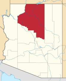 | |
| Towns | ||
| CDPs | ||
| Unincorporated communities |
| |
| Indian reservations | ||
| Ghost town | ||
| Footnotes | ‡This populated place also has portions in an adjacent county or counties | |