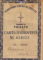
Free Territory of Trieste
| Free Territory of Trieste | ||||||||||||
| Territorio Libero di Trieste Svobodno tržaško ozemlje Slobodni teritorij Trsta | ||||||||||||
| Independent territory under direct responsibility of the United Nations Security Council | ||||||||||||
| ||||||||||||
| ||||||||||||
 | ||||||||||||
| Capital | Trieste | |||||||||||
| Languages | Italian · Slovene · Serbo-Croatian · English (only for administrative purposes) | |||||||||||
| Religion | Catholicism, Serbian Orthodox, Judaism | |||||||||||
| Demonym | Triestine | |||||||||||
| Government | UN Security Council-controlled temporary military government | |||||||||||
| President | ||||||||||||
| • | 1947–1951 | Terence Sydney Airey Mirko Lenac | ||||||||||
| • | 1951–1954 | Thomas Winterton Miloš Stamatović | ||||||||||
| Legislature | Council of Government (never designated) | |||||||||||
| Historical era | Cold War | |||||||||||
| • | Established | 1947 | ||||||||||
| • | Disestablished | 1954 | ||||||||||
| Currency | Italian lira (zone A) Triestine lira (zone B)[1] | |||||||||||
| ||||||||||||
| Today part of | | |||||||||||

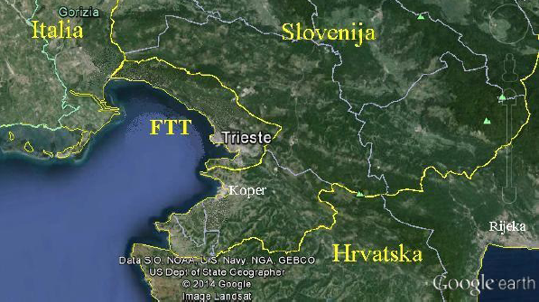
The Free Territory of Trieste (Italian: Territorio libero di Trieste, Slovene: Svobodno tržaško ozemlje; Serbo-Croatian: Slobodni teritorij Trsta) was an independent territory situated in Central Europe between northern Italy and Yugoslavia, facing the north part of the Adriatic Sea, under direct responsibility of the United Nations Security Council in the aftermath of World War II.
The Free Territory was established on 10 February 1947 by a protocol of the Treaty of Peace with Italy in order to accommodate an ethnically and culturally mixed population in a neutral independent country. The intention was also to cool down territorial claims between Italy and Yugoslavia, due to its strategic importance for trade with Central Europe. It came into existence on 15 September 1947. Its administration was divided into two areas: one being the port city of Trieste with a narrow coastal strip to the north west (Zone A); the other, larger (Zone B) was formed by a small portion of the north-western part of the Istrian peninsula.
The Free Territory was de facto taken over by its two neighbours in 1954 and this was formalized much later by the bilateral Treaty of Osimo of 1975, ratified in 1977.[2]
Geography
The Free Territory of Trieste comprised an area of 738 km² around the Bay of Trieste from Duino/Devin in the north to Novigrad/Cittanova in the south, and had approximately 330,000 inhabitants. It bordered the new Italian Republic to the north, and the Socialist Federal Republic of Yugoslavia to the south and to the east. The rivers of the territory included the Rižana/Risano, the Dragonja/Dragogna, the Timavo/Timava, the Val Rosandra/Glinščica and the Mirna/Quieto. The Territory's highest point was at Monte Cocusso/Kokoš (668 m). Its most extreme points were near Medeazza/Medjavas at 45° 48’ in the north, at Tarski Zaliv/Porto Quieto at 45° 18’ in the south, Savudrija/Punta Salvore at 13° 29’ in the west and Gročana/Grozzana at 13° 55’ in the east.
History

Since 1382, Trieste had been part of the Habsburg Monarchy, whilst Istria had been divided for centuries between the Habsburg Monarchy (its central, northern and eastern parts) and the Republic of Venice (its western and southern parts). The population of the territory has been diverse and mixed, with different and often changing ethnic majorities in different parts of the territory. Italian-speakers have been predominant in most urban settlements and in the coast, with strong minorities of Slovenes and Croats, especially in Trieste district, where Slovenes represented a third of the population by the end of World War I (most of them however were of recent arrivals, after 1880, from interior Slovene districts).[3][4] The countryside of the territory was mostly Slovene or Croatian in the southernmost portion of the area. There was also a smaller number of Istro-Romanians, Greeks, Albanians and a strong Triestine Jewish community.
An example of this ethnic mix is the Triestine dialect. Its base is derived from Venetian, influenced by a Friulian substrate, mainly due to the existence of the now defunct Tergestine dialect, which was closely related to Friulian. Some of the Triestine words are of German and Slovene origin and also came from other languages, such as Greek.
The variations of spoken Slovenian and Croatian in the territory were also largely dialectal, sharing words with the Triestine and Istrian dialects. In the southernmost part of the territory the Croatian-based dialects were of the Chakavian type, while the Venetian-based Istrian is also commonly used.

In 1921, after World War I, Italy annexed Trieste, Istria and part of modern-day western Slovenia, establishing the border region known as the Julian March (Venezia Giulia). In 1924, Italy annexed the Free State of Fiume, now the city of Rijeka in Croatia.
During the 1920s and 1930s, the Slavic population was subjected to forced Italianization and discrimination under the Italian fascist regime. They were also exposed to state violence by fascist party mobs, including the burning of the Slovene National Hall in Trieste on July 13, 1920, and also in other towns and villages. A few Slovenes and Croats consequentially emigrated to Yugoslavia, while some joined the TIGR resistance organization, whose methods included more than 100 acts of terrorism, mostly against the exponents of the Italian authorities in the region (especially in the provinces of Trieste and Gorizia).
World War II

Italy fought with the Axis powers in World War II. When the Fascist regime collapsed in 1943 and Italy capitulated, the territory was occupied by German forces who created the Operational Zone of the Adriatic Littoral, the capital of which was Trieste. The Yugoslav 4th Army and the Slovenian 9th Corps entered Trieste on May 1, 1945, after a battle in the town of Opicina. The 2nd Division (New Zealand) arrived on the next day and forced the surrender of the 2,000 German Army troops holding out in Trieste, who warily had refused to capitulate to partisan troops, fearing they would be executed by them. An uneasy truce developed between New Zealand and Yugoslav troops occupying the area until British Gen. Sir William Morgan proposed a partition of the territory and the removal of Yugoslav troops from the area occupied by the Allies. Yugoslav leader Josip Broz Tito agreed in principle on May 23, as the British XIII Corps was moving forward to the proposed demarcation line. An agreement was signed in Duino on June 10, creating the Morgan Line. The Yugoslav troops withdrew by June 12, 1945.[5][6]
Establishment of the territory and first Provisional Governments
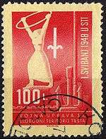
In January 1947, the United Nations Security Council approved Resolution 16 under Article 24 of its charter calling for the creation of a free state in Trieste and the region surrounding it. A permanent statute codifying its provisions was to become recognized under international law upon the appointment of an international governor approved by the Quatripartite Powers. On September 15, 1947, the peace treaty between the United Nations and Italy was ratified, establishing the Free Territory of Trieste. Official languages were Italian and Slovene, possibly with the use of Croatian in the portion of Zone B south of the Dragonja river. However, the territory never received its planned self-government and it was maintained under military occupation respecting the administrative division into two zones as decided by the Morgan Line: Zone A, which was 222.5 km² and had 262,406 residents including Trieste, was administered by British and American forces, while Zone B, which was 515.5 km² with 71,000 residents including north-western Istria, was administered by the Yugoslav National Army.

Between October 1947 and March 1948, the Soviet Union rejected the candidacy of 12 nominations for governor, at which point the Tripartite Powers (United States, United Kingdom, and France) issued a note to the Soviet and Yugoslav governments on March 20, 1948 recommending that the territory be returned to Italian sovereignty. No governor was ever appointed under the terms of the UN Resolution. The Territory thus never functioned as a real independent state, although its formal status was generally respected and it was involved in the European Recovery Plan (ERP) and in many international organizations (OEEC).[7] The B zone even issued its own postage stamps. The break between the Tito government and the USSR in mid-1948 resulted in the proposal to return the territory to Italy being suspended until 1954.
The Allied Military Government administered Zone A, which was divided into peacekeeping and law enforcement sectors protected by a command of 5,000 Americans ("TRUST", the TRieste United States Troops) and 5,000 British in "BETFOR" (British Element Trieste FORce), each comprising a brigade-sized infantry force and complete support units (signals, engineers, military police, etc.)
According to the estimates published by the Allied Military Government, as of 1949 in the A zone there were about 310,000 inhabitants,[8] including 239,200 Italians and 63,000 Slovenes. The last Austrian census of 1910/1911 registered around 72,000 Slovene and 2,000 Croatian speakers in the area, and around 160,000 Italian speakers. According to contemporary Italian sources, in zone B there were 36,000-55,000 Italians and 12,000-17,000 Slovenes and Croats. According to the Yugoslav census of 1945, which was considered falsified by the Quadripartite Commission set up by the United Nations,[9] in the part of Istria which was to become Zone B there were 67,461 inhabitants, including 30,789 Slovenes and Croats, 29,672 Italians and 7,000 people of unidentified nationality.
Second Provisional Governments
On 5 October 1954, the London Memorandum was signed in the British capital by ministers of the United States, United Kingdom, Italy, and Yugoslavia. It handed over administration of Zone A to the Italian Government, and administration over Zone B to the Yugoslav Government.[10]
The London Memorandum gave former Zone A with Trieste to Italy for an ordinary civil administration, and Zone B, which had already had a communist government since 1947, to Yugoslavia. In addition, Yugoslavia was given several villages in the Muggia municipality that had been part of Zone A: Plavje, Spodnje Škofije, Jelarji, Hrvatini, Kolomban, Cerej, Premančan and Barizoni. The castle and village of Socerb above San Dorligo della Valle was also ceded to Yugoslavian administration, according to the demarcation line defined by Annex I to the London Memorandum.
In 1975 the bilateral Treaty of Osimo was signed in Osimo and ratified two years later, confirmed the validity of the Memorandum of London, ending its effects only in relations between the States of Italy and Yugoslavia[11] which, however, were not its signatories, for the Memorandum of London was signed by their Governments and the Governments of the United States of America and of the United Kingdom. This bilateral agreement, however, is important because it ended official territorial claims over the Free Territory of Trieste by Italy and Yugoslavia. After the dissolution of Yugoslavia and proclamation of independence of Slovenia and Croatia in 1991-1992, only former Zone A survives as the present-day Free Territory of Trieste, under the temporary civil administration of the Italian Government established with the Memorandum of London.[12]
Governors of the Territory
Zone A
Military commander
| Governor | In Office | Country |
|---|---|---|
| Maj. Gen. Bernard Cyril Freyberg * | May 2, 1945 - July 1945 | New Zealand |
| Col. Alfred Connor Bowman * | July 1945 - July 1947 | United States |
| Col. James Jewett Carnes * | July 1947 - September 15, 1947 | |
| Maj. Gen. Sir Terence Sydney Airey | September 15, 1947 - March 31, 1951 | United Kingdom |
| Maj. Gen. Sir Thomas John Willoughby Winterton | April 1, 1951 - October 26, 1954 |
Zone B
Military commander
| Governor | In Office | Country |
|---|---|---|
| Dušan Kveder * | May 1, 1945 - September 1947 | Yugoslavia |
| Mirko Lenac | September 15, 1947 - March 1951 | |
| Miloš Stamatović | March 1951 - October 25, 1954 |
*Governors of all Julian March prior to the establishment of the Territory.[13]
Economics
The economy of the area formerly part of the territory is based on its ports, namely the Free Port of Trieste and the Port of Koper/Capodistria. The first has a peculiar free zone (nowadays also offshore) status originated in 1719[14] and confirmed by the Treaty of Peace with Italy of 1947, which allows the transportation of goods inside the area. This status is recognised by the international community and the European Union.[15][16]
An extract from the answer given by Algirdas Šemeta on August 7, 2012, on behalf of the European Commission about the Free Port of Trieste:[15]
Annex VIII to the Treaty of peace with Italy of 10 February 1947 stipulates in its Article 1 that the port of Trieste shall be a customs free port. Article 5(2) of Annex VIII provides that in connection with importation into or exportation from or transit through the Free Port, the authorities of the Free Territory shall not levy on such goods customs duties or charges other than those levied for services rendered.[15] [emphasis added]
The port economy is suffering from poor railway connections due to high tariffs and from the lack of a modernized infrastructure.[17] The "Galleria di cintura" railway between the new and the old parts of the Port of Trieste were renovated and enlarged in 2010,[18] yet it remains largely unused.
Demographics
During the late 1940s and in the years following the division of the Territory, up to 40,000 people[19] (mostly Italians) chose to leave the Yugoslav B zone and move to the A zone or Italy for various reasons: Some were intimidated into leaving, and some simply preferred not to live in Yugoslavia. In Yugoslavia, the people who left were called optanti ("choosing"), while they call themselves esuli ("exiles"). About 14,000 Italians chose to remain in the Yugoslav zone, currently divided between Slovenia and Croatia.
While the Free Territory of Trieste amounted to approximately 370,000 inhabitants in 1949, today's estimate is around 330,000, meaning a decrease of approximately 10.8%. In comparison, the number of inhabitants in Europe has increased considerably during the same time period, making the area a clear case of population decline, especially in the Trieste area.
See also
- Treaty of peace with Italy (1947)
- Communist Party of the Free Territory of Trieste
- United Nations Security Council Resolution 16
- Julian March
- Istrian exodus
- Morgan Line
- Slovene Littoral
- Province of Trieste
- Slovenian Istria
- Istria County
References
- ↑ "A/AC.25/Com.Jer/W.4". United Nations. Retrieved 5 June 2013.
- ↑ Drašček, Nuša. "Slovenska zahodna meja po drugi svetovni vojni", diplomsko delo, Univerza v Ljubljani, Ljubljana, 2005
- ↑ http://www.kozina.com/premik/1910-02.pdf
- ↑ http://www.kozina.com/premik/1910.htm
- ↑ Stanford University
- ↑ Ashburton Guardian
- ↑ "Organisation for European Economic Co-operation - OECD". www.oecd.org. Retrieved 2015-09-24.
- ↑ http://www.milhist.net/docs/intellrev.html#59
- ↑ United States Intelligence Review, Issue 3, 28 February 1946
- ↑ United Nations Treaty Series 1956; No. 3297.
- ↑ United Nations Treaty Series 1996; No. 1464.
- ↑ http://www.securitycouncilreport.org/atf/cf/%7B65BFCF9B-6D27-4E9C-8CD3-CF6E4FF96FF9%7D/s_2015_809.pdf. External link in
|title=(help) - ↑ Worldstatesmen / Italy / Trieste by Ben Cahoon
- ↑ The port of Trieste and its railway connections in the Habsburg monarchy: economic change and infrastructure problems, 1850-1918
- 1 2 3 Answer given by Mr Šemeta on behalf of the Commission, August 2012
- ↑ The jurisdictional regime of the Free Zones (in Italian)
- ↑ Austrian trains enter the port (2011, in Italian)
- ↑ The "Galleria di cintura" now runs on two tracks (2010, in Italian)
- ↑ Arrigo Petacco, The exodus. The story of the Italian population of Istria, Dalmatia, and Venezia Giulia, Mondadori, Milan, 1999. English translation.
External links
| Wikimedia Commons has media related to Free Territory of Trieste. |
- Vintage Life Magazine Photos of Trieste at Google Images.
- The present-day Free Territory of Trieste: http://www.lavoceditrieste.net/wp-content/uploads/2014/12/FreeTerritoryofTrieste_map.png
- http://www.securitycouncilreport.org/atf/cf/%7B65BFCF9B-6D27-4E9C-8CD3-CF6E4FF96FF9%7D/s_2015_809.pdf
Coordinates: 45°41′N 13°45′E / 45.68°N 13.75°E
| History |
|  |
|---|---|---|
| Geography and surrounding area | ||
| Buildings and landmarks | ||
| Places of worship |
| |
| Culture | ||
| Local media |
| |
| Education and research | ||
| Sports venues |
| |
| Transport | ||