Freehold, Greater Manchester
Coordinates: 53°32′04″N 2°08′07″W / 53.534326°N 2.13531°W
Freehold is an urban area of Werneth in Oldham, Greater Manchester, England. It occupies an area in the west of Werneth close to the Oldham town boundary with Chadderton. It is contiguous on all sides with other urban areas including other parts of Werneth to the north and east and with Cowhill, Block Lane and Butler Green/Washbrook in Chadderton.
Freehold is centred on Oxford Street and is broadly bounded by Manchester Road, Edward Street, the former Oldham Loop Line railway, Block Lane and Suffolk Street.[1]
The place-name of Freehold isn't widely used in the area and doesn't exist as a postal address, the locality being generally known by the wider district name of Werneth.
The area was partly redeveloped as part of the government's Housing Market Renewal Initiative – the Werneth Freehold Masterplan – comprising Freehold, Block Lane and some small adjacent parts of north Werneth and south Chadderton, however some parts of Freehold have remained derelict since the early 2000s following loss of funding for the initiative.[2][3]
Freehold Metrolink station opened in 2012 at the Oldham/Chadderton boundary at Block Lane, and serves both the Freehold area of Oldham and the Cowhill/Block Lane areas of Chadderton. The station's position on the boundary means it lies partially in both Chadderton and Oldham.[4]
Freehold Community School was built in 1982 on the site of Blackridings Mill which was demolished in 1975.[5] The school has a history dating to 1880, being originally located on Derby Street close to its junction with Manchester Road. The school also used the Stanley Road School building in the Butler Green area for a period up until the construction of the new school.[6]
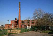
The Hartford Mill is a Grade II listed building in the area dating from 1907, ceasing cotton production in 1969. The mill, however, has fallen into dereliction and an application to have the building de-listed and demolished has been approved by the owners and the local authority.[7]
History
Previously a coal mining area, industrial expansion in the Werneth area in the mid-19th century led to the construction of Oxford Street in the early 1860s along what was a footpath linking Manchester Road (now the A62) at Werneth to the ancient road and hamlet of Block Lane.[8]
The driving force for expansion was Platt Brothers industrial complex around Werneth Station in the northern part of the area. Platts were for a time the largest manufacturers of machinery for the cotton industry in the world employing some 15,000 people.[1]
The opening of Oxford Street led to the construction of side streets linking to Manchester Road and Block Lane and by 1914 the area had been completely covered by rows of terraced housing for workers of Platts, Black Ridings Mill and factories in the Old Lane area lying directly to the south.[1]
Freehold had a number of public houses only one of which remains. The Royal Oak, Manchester Road, dates back to 1825.[9]
Religion
Freehold is part of the parish of Christ Church (Church of England), Block Lane.
Freehold's increasing population in the mid 19th century saw Cowhill Methodist Church expand its ministry into this area and a decision was made to build a chapel in Rutland Street, Werneth, half a mile away from Cowhill, and in 1861 the foundations where laid for one of the largest churches in Oldham, Brunswick Wesleyan Methodist church which opened in 1862. The church closed in 1954.[10] Cowhill became prolific at building churches. Two more building projects including a new school for Brunswick, on Oxford Street, opened in January 1890.[11]
The congregation moved to Edward Street Methodist Church (500 yards from Rutland Street) which itself dates back to 1861. That church closed in 1967 when it amalgamated with several other local churches, including Cowhill Methodist Church, to form South Chadderton Methodist Church at Butler Green.[12]
Freehold is home to a large Muslim population and three mosques serve the area, The Werneth Jamia Masjid, Manchester Road, The Markazi Mosque (capacity 1600), Suffolk Street and Jamia Islamia Ghamkolia Mosque on Warwick Street.
Werneth Jamia Masjid was the first masjid to be established in the Werneth area of Oldham. The building was previously used as a grocery store and was purchased in 1976 to be converted into a much needed place of worship. The local community helped raise the £7,200 required to purchase the property through donations.[13][14][14]
Transport
.JPG)
First Greater Manchester operate bus services 81, 81a and 83 linking Freehold with Derker, Holts Estate and Sholver via Oldham town centre and with Manchester City centre, via Moston and Failsworth.
Manchester Community Transport operates bus services 159 to Oldham via Chadderton town centre and to Middleton via Hollinwood, Woodhouses, Failsworth and New Moston plus service 419 providing links to Ashton-U-Lyne and to Middleton via Chadderton town centre .[15][16][17]
Freehold Metrolink station provides direct tram links to Manchester and beyond and to Rochdale Railway Station and town centre.[18]
References
- 1 2 3 http://media.urbed.coop.ccc.cdn.faelix.net/sites/default/files/Oldham%20Beyond%20Werneth.pdf|Urbed - Werneth Freehold Action Plan
- ↑ "Werneth Freehold Masterplan | Urbed". Urbed.coop. Retrieved 2013-06-29.
- ↑ http://www.oldham-chronicle.co.uk/news-features/8/news-headlines/84366/custombuilt-homes-a-key-to-regeneration
- ↑ http://www.metrolink.co.uk/stationinfo/Documents/freehold.pdf|Freehold Metrolink Station Information
- ↑ P53 Gurr, Duncan; Hunt, Julian (1998), The Cotton Mills of Oldham, Oldham Education & Leisure, ISBN 0-902809-46-6
- ↑ http://www.oldham-chronicle.co.uk/news-features/8/news-headlines/95114/academy-is-aiming-high
- ↑ http://www.oldham-chronicle.co.uk/news-features/8/news-headlines/90598/final-curtain-for-derelict-mill
- ↑ Chadderton Pubs And Their Licencees 1750–1999, Magee Rob (1986) ISBN 978-1-85216-134-7
- ↑ P61 Inns and Alehouses of Oldham and their licencees, Rob Magee. ISBN 1-85216-073-X
- ↑ http://www.genuki.org.uk/cgi-bin/churchentry?CCC=LAN,ID=4326,FT=Werneth%20Brunswick%20Rutland%20Street%20Wesleyan%20Methodist| Genuki Brunswick, Werneth- Wesleyan Methodist retrieved 11 August 2013
- ↑ http://www.southchad.org.uk/Cowhill.html| History of Cowhill Methodist Church - Retrieved 11 August 2013
- ↑ http://www.southchad.org.uk/EdwardSt.htm
- ↑ http://www.wernethjamiamasjid.org.uk/
- 1 2 http://mosques-map.muslimsinbritain.org/maps.php#/mosque/2034
- ↑ "Transport for Greater Manchester - Journey Planning - Network Maps". Transport for Greater Manchester. Retrieved 7 February 2014.
- ↑ "Service 152 Chadderton - Firwood Park" (PDF). Stagecoach Manchester. 7 February 2014. Retrieved 31 July 2013.
- ↑ http://www.tfgm.com/buses/Pages/service_changes.aspx
- ↑ http://www.metrolink.co.uk/stationinfo/Pages/Freehold.aspx
 |
Cowhill | Cowhill | Westwood | |
| Nimble Nook | |
Werneth | ||
| ||||
| | ||||
| Butler Green | Block Lane | Top of Hollinwood |
External links
Werneth Freehold Masterplan http://www.urbed.coop/projects/werneth-freehold-masterplan
Werneth and Freehold Community Development Project http://wfcdp.com/
Freehold Community School http://www.freehold.oldham.sch.uk/welcome-page
Werneth Jamia Masjid http://www.wernethjamiamasjid.org.uk/