Freienorla
| Freienorla | |
|---|---|
 Freienorla | |
Location of Freienorla within Saale-Holzland-Kreis district  | |
| Coordinates: 50°46′10″N 11°32′34″E / 50.76944°N 11.54278°ECoordinates: 50°46′10″N 11°32′34″E / 50.76944°N 11.54278°E | |
| Country | Germany |
| State | Thuringia |
| District | Saale-Holzland-Kreis |
| Municipal assoc. | Südliches Saaletal |
| Government | |
| • Mayor | Ulrich Eismann |
| Area | |
| • Total | 6.81 km2 (2.63 sq mi) |
| Population (2015-12-31)[1] | |
| • Total | 329 |
| • Density | 48/km2 (130/sq mi) |
| Time zone | CET/CEST (UTC+1/+2) |
| Postal codes | 07768 |
| Dialling codes | 036423 |
| Vehicle registration | SHK, EIS, SRO |
| Website | www.freienorla.de |
Freienorla is located in the German state of Thuringia. Although quite small and obscure, the municipality is known locally for its Gothic church as well as its lower mill, a watermill facility thought to be built in the tenth century. The Orlaban railroad has a station located in Freienorla. Neighnbouring towns include Jena and Eisenberg . Freienorla is located 145 miles from the capital of Berlin.
-

Gothic church
-
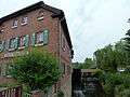
Lower mill
References
http://www.worldcities.us/Freienorla
External links
This article is issued from Wikipedia - version of the 8/14/2016. The text is available under the Creative Commons Attribution/Share Alike but additional terms may apply for the media files.