Weißenborn, Thuringia
| Weißenborn | |
|---|---|
 Weißenborn | |
Location of Weißenborn within Saale-Holzland-Kreis district 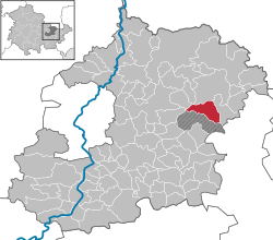 | |
| Coordinates: 50°55′18″N 11°52′50″E / 50.92167°N 11.88056°ECoordinates: 50°55′18″N 11°52′50″E / 50.92167°N 11.88056°E | |
| Country | Germany |
| State | Thuringia |
| District | Saale-Holzland-Kreis |
| Municipal assoc. | Bad Klosterlausnitz |
| Government | |
| • Mayor | Mike Lichtner |
| Area | |
| • Total | 10.04 km2 (3.88 sq mi) |
| Population (2015-12-31)[1] | |
| • Total | 1,167 |
| • Density | 120/km2 (300/sq mi) |
| Time zone | CET/CEST (UTC+1/+2) |
| Postal codes | 07639 |
| Dialling codes | 036601 |
| Vehicle registration | SHK, EIS, SRO |
| Website | www.weissenborn-thueringen.de |
Weißenborn is a municipality in the district Saale-Holzland, in Thuringia, Germany. It is located nearby the Motorways A4 and A9.
References
This article is issued from Wikipedia - version of the 10/29/2015. The text is available under the Creative Commons Attribution/Share Alike but additional terms may apply for the media files.