Frenchtown, Montana
| Frenchtown, Montana | |
|---|---|
| CDP | |
 | |
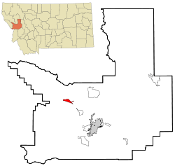 Location of Frenchtown, Montana | |
| Coordinates: 47°1′8″N 114°14′46″W / 47.01889°N 114.24611°WCoordinates: 47°1′8″N 114°14′46″W / 47.01889°N 114.24611°W | |
| Country | United States |
| State | Montana |
| County | Missoula |
| Area | |
| • Total | 3.3 sq mi (8.5 km2) |
| • Land | 3.2 sq mi (8.4 km2) |
| • Water | 0.0 sq mi (0.1 km2) |
| Elevation | 3,045 ft (928 m) |
| Population (2010) | |
| • Total | 1,825 |
| • Density | 271.8/sq mi (104.9/km2) |
| Time zone | Mountain (MST) (UTC-7) |
| • Summer (DST) | MDT (UTC-6) |
| ZIP code | 59834 |
| Area code(s) | 406 |
| FIPS code | 30-29350 |
| GNIS feature ID | 0783746 |

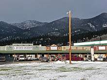
Frenchtown is a census-designated place (CDP) in Missoula County, Montana, United States. It is part of the 'Missoula, Montana Metropolitan Statistical Area'. The population was 1,825 at the 2010 census, an increase from its population of 883 in 2000.
History
A post office called Frenchtown was first established in 1868.[1] A large share of the early settlers being French Canadians caused the name to be selected.[2]
Geography
Frenchtown is located at 47°01′08″N 114°14′46″W / 47.018780°N 114.246205°W (47.018780, -114.246205),[3] on the historic Mullan Road.[4]
According to the United States Census Bureau, the CDP has a total area of 3.3 square miles (8.5 km2), of which, 3.2 square miles (8.3 km2) of it is land and 0.04 square miles (0.10 km2) of it (0.91%) is water.
Demographics
As of the census[5] of 2010, there were 1,825 people, 291 households, and 235 families residing in the CDP. The population density was 271.8 people per square mile (104.9/km2). There were 302 housing units at an average density of 92.9 per square mile (35.9/km2). The racial makeup of the CDP was 96.15% White, 1.59% Native American, 0.11% Asian, 0.79% from other races, and 1.36% from two or more races. Hispanic or Latino of any race were 1.81% of the population.
There were 291 households out of which 47.4% had children under the age of 18 living with them, 67.0% were married couples living together, 7.9% had a female householder with no husband present, and 19.2% were non-families. 12.7% of all households were made up of individuals and 4.1% had someone living alone who was 65 years of age or older. The average household size was 3.03 and the average family size was 3.32.
In the CDP the population was spread out with 34.3% under the age of 18, 6.5% from 18 to 24, 31.3% from 25 to 44, 22.7% from 45 to 64, and 5.3% who were 65 years of age or older. The median age was 34 years. For every 100 females there were 106.3 males. For every 100 females age 18 and over, there were 101.4 males.
The median income for a household in the CDP was $46,094, and the median income for a family was $45,938. Males had a median income of $36,118 versus $23,750 for females. The per capita income for the CDP was $21,225. None of the population or families were below the poverty line.
Smurfit-Stone mill
In September 2015, the EPA announced that it was close to an agreement for testing and environmental remediation of Frenchtown's Smurfit-Stone Container Corp. mill site.[6] Contaminants on the site include dioxins and heavy metals, which has raised concerns that the site might be eligible for the federal Superfund list.[7] The paper mill, which produced containerboard, "began production in 1957 under Waldorf Paper Products Co. of St. Paul, MN."[8] It mill employed 417 workers at the time of its closure in 2010.[9]
| Wikimedia Commons has media related to Frenchtown, Montana. |
References
- ↑ "Missoula County". Jim Forte Postal History. Retrieved 27 April 2015.
- ↑ "Origins of Names on Milwaukee". Roundup Record-Tribune & Winnett Times. August 22, 1940. p. 6. Retrieved 27 April 2015.
- ↑ "US Gazetteer files: 2010, 2000, and 1990". United States Census Bureau. 2011-02-12. Retrieved 2011-04-23.
- ↑ Briggeman, Kim (July 4, 2012). "Road to Frenchtown has changed since Stone's journey". Missoulian. Retrieved 2015-10-03.
- ↑ "American FactFinder". United States Census Bureau. Retrieved 2008-01-31.
- ↑ Kidston, Martin (2015-10-03). "EPA pledges progress in 'month or two' at former Smurfit site". Missoulian. Retrieved 2015-10-03.
- ↑ Chaney, Rob (September 13, 2012). "Former Frenchtown mill site may need Superfund cleanup". Missoulian. Retrieved 2015-10-03.
- ↑ Briggeman, Kim (May 5, 2011). "Investment group buys Smurfit's Frenchtown mill" (PDF). Missoulian via logging.com. Retrieved 2015-10-03.
- ↑ Cohen, Betsy (January 3, 2010). "Smurfit-Stone closure: Towns struggle to put old mill sites to use". Missoulian. Retrieved 2015-10-03.
Municipalities and communities of Missoula County, Montana, United States | ||
|---|---|---|
| City | 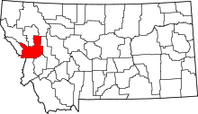 | |
| CDPs | ||
| Unincorporated communities | ||
| Ghost towns | ||
| Indian reservation | ||
| Footnotes | ‡This populated place also has portions in an adjacent county or counties | |